FTB 09-21-2016: Plenty of Moisture, But It’s All Too High in the Sky

Issue Date: Wednesday, September 21st, 2016
Issue Time: 10:00AM MDT

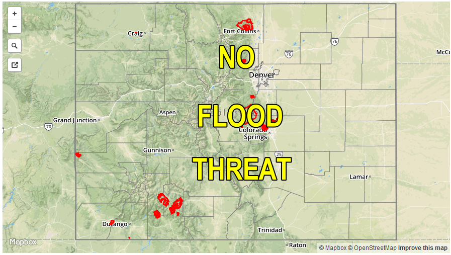
— Flooding is NOT expected today

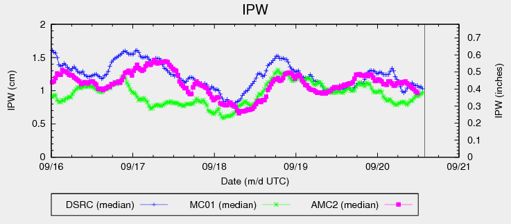
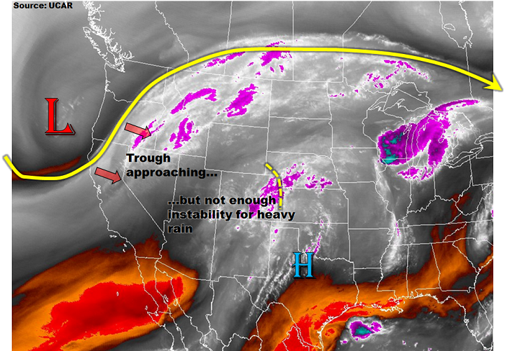
The large-scale trough, which has been predicted rather well over the past 3-4 days, is finally coming onshore on the US west coast (see water vapor image below). The dynamics with this feature are impressive, but Colorado will have to wait at least one more day before our weather is impacted. In addition to the trough, a weak disturbance is also noted on the CO/KS border this morning. This is causing widespread mid/high clouds east of the Divide, along with some virga in far eastern Colorado. The main impact of this feature will likely be to limit afternoon heating, though it will remain warm east of the Continental Divide. Moisture has increased markedly over the past 24-hours with most of western CO now approaching precipitable water (PW) values of near 1 inch. Even east of the Divide, PW values have slowly increased into the 0.6 – 0.8 inch range. Despite this increase in moisture, it is limited to such high altitude that it will simply not be a factor in generating heavy rainfall. Moreover, as the low pressure trough approaches, upper-level warm air advection will actually build a weak ridge over Colorado today. Overall, expect scattered rain showers and a few weak thunderstorms mainly west of the Divide, but flooding is once again not expected today.

wv_markup

Today’s Flood Threat Map

For more information on today’s flood threat, see the map below (hover over threat areas for more details). For Zone-Specific forecasts, scroll below the map.

Flood Threat Legend

Zone-Specific Forecasts:

Southeast Plains, Northeast Plains, Palmer Ridge, Raton Ridge, Front Range, Urban Corridor, Southeast Mountains:

Mostly cloudy early then turning partly cloudy and continued warm with high temperatures up to 15F above normal towards the CO/KS border. An isolated shower or weak thunderstorm cannot be ruled out. Favored areas will be along the foothills of the entire I-25 corridor (max 1-hr rainfall 0.3 inches) as well as the far southeast (max 1-hr rainfall 0.6 inches). However, flooding is not expected today.

San Juan Mountains, Southwest Slope, Grand Valley, Central Mountains, San Luis Valley, Northwest Slope, Northern Mountains:

Partly to mostly cloudy skies and seasonably warm today. Isolated showers will increase in coverage with a few weak thunderstorms possible by mid-afternoon. Max 1-hour rain rates up to 0.4 inches are possible. Max 24-hour rain totals up to 0.9 inches are possible by tomorrow morning over favored higher elevation, west-facing regions of the San Juans, Central Mountains, Southwest Slope and Grand Valley. However, flooding is not expected today.

FTB 09-20-2016: Remaining Warm with Increasing Moisture/Clouds

Issue Date: 9/20/2016
Issue Time: 9:16 AM

NO FLOOD THREAT IS FORECAST.

Cloud cover across the state has increased significantly since sunset last night due to mid- and high-level moisture streaming in from the southwest. Even with the increase in moisture, IPW values are still fairly meager, however, as evidenced in the IPW chart below. This is due to the low-levels remaining on the dry side, with most of the moisture residing 3 km (or more) above the ground. Eventually, low-level moisture will increase from the southwest across western Colorado, but this will hold off until the late evening hours tonight and into the early morning hours tomorrow. In the meantime, the lack of low-level moisture will fight precipitation chances throughout the day and into the evening hours. At best, isolated light sprinkles/showers, and perhaps a weak thunderstorm or two, are possible across the higher terrain along/west of the Continental Divide. Not much rainfall is expected. East of the Divide, increased cloud cover, dry conditions, and continued warmth will be the main weather story.

ipw_20160920

As alluded to above, moisture will increase during the late evening and early morning hours tomorrow, especially across western Colorado. This will result in the Wednesday portion of this forecast period (Midnight – 11 AM tomorrow) the most active, relatively speaking. An increase in shower coverage, with a few embedded thunderstorms, is expected across the High Country and Western Slope, with an isolated shower/weak storm spilling over into the Front Range and Southeast Mountains regions. Most precipitation is expected to remain light, with any thunderstorms producing brief periods of moderate rainfall. No flood threat will be issued, due to rain rates expected to remain well below thresholds. For more information on timing and rain rates, please see the zone-specific forecast discussions below.

Today’s Flood Threat Map

For more information on today’s flood threat, see the map below (hover over threat areas for more details). For Zone-Specific forecasts, jump below the map.

nofloodthreat
Flood Threat Legend

Zone-Specific Forecasts

Urban Corridor, Palmer Ridge, Northeast Plains, Raton Ridge and Southeast Plains:

Plenty of mid- and high-level clouds will be situated across the area today, with high temperatures expected to remain above normal, albeit a few degrees cooler than yesterday. No precipitation is expected for these regions, but a few streaks of virga may grace the sky during the morning hours tomorrow.

Front Range, Southeast Mountains, Northern Mountains, Northwest Slope, San Juan Mountains, Southwest Slope, San Luis Valley, Central Mountains, and Grand Valley:

Clouds are expected to increase throughout the day, with high temperatures expected to be a few degrees cooler than yesterday. A few light showers, and perhaps a weak thunderstorm or two, will pop up across areas along/west of the Continental Divide during the late afternoon/early evening hours, mainly south of I-70. Precipitation will generally be light, and not a cause for any flood threat issuance. During the late evening/overnight hours, low-level moisture will increase from the southwest. Activity will ramp up through tomorrow morning, with a couple isolated showers/weak storms spilling over into the Front Range and Southeast Mountains regions. Still, rain rates will remain below flash flood thresholds, so no flood threat will be issued. Maximum rain rates are as follows:

Front Range, Northern Mountains, Northwest Slope, San Luis Valley, Central Mountains, Grand Valley, and Southeast Mountains: 0.2-0.4 inches/hour
Southwest Slope and San Juan Mountains: 0.4-0.6 inches/hour

Timing: 3 PM – 11 AM

FTB 09-19-2016: Continued Dry Today but Change is Coming

Issue Date: 9/19/2016
Issue Time: 9:15 AM

NO FLOOD THREAT IS FORECAST.

Persistent ridging aloft will continue to define the weather today.  Dry westerly flow will do little to bring moisture into the state as IPW and Relative Humidity values continue to stay at subdued levels (see below).  Autumn will attempt to evade the area as temperatures will remain unseasonably warm with high temperatures approaching the low 90’s in the Eastern Plains, Urban Corridor, and Raton Ridge, or about 10 to 15 degrees above normal for this time of year. Western portions of the Southwest and Northwest Slope regions will also experience highs that are unseasonably warm as these areas will likely make it into the low- to mid-80’s. Flow aloft is expected to be weaker than yesterday, which will cause reduced winds and a lower, albeit still elevated, fire danger risk compared to yesterday. Please visit your local NWS office website for more details.

5674relativehumidity

A changing weather pattern can be expected as the week progresses and as deep moisture from Tropical Storm Paine may begin to enter extreme western portions of the state as soon as Tuesday night.

Today’s Flood Threat Map

For more information on today’s flood threat, see the map below (hover over threat areas for more details). For Zone-Specific forecasts, jump below the map.

Flood Threat Legend

Zone-Specific Forecasts

Northeast Plains, Urban Corridor, Palmer Ridge, Southeast Plains, and Raton Ridge:

It will continue to be sunny, dry, and hot today, with temperatures reaching levels that will be 10 to 15 degrees above normal for this time of year. Fire hazard potential will remain elevated for the Northeast Plains and Urban Corridor, but due to weaker winds, they will not be as severe as they were yesterday.

Front Range, Southeast Mountains, Northern Mountains, Northwest Slope, Grand Valley, Central Mountains, San Juan Mountains, Southwest Slope, and San Luis Valley:

Plenty of sunshine with little chance of moisture will define the weather today throughout all regions as a high pressure sits over the area. Winds will be less but a fire danger still exists in the Northern Mountain and Front Range regions. Enjoy the weather today as moisture from the remnants of Tropical Storm Paine will enter the region in the next few days beginning as early as Tuesday night.

FTB 09-18-2016: Dry Conditions Expected

Issue Date: 9/18/2016
Issue Time: 9:05 AM

NO FLOOD THREAT IS FORECAST.

One look at the IPW graph below tells a big chunk of today’s weather story, showing just how dry the atmosphere has become in the last 24-48 hours. For today/tonight, ridging aloft will keep the atmosphere subdued across Colorado, resulting in a day of late-summer warmth and mostly sunny skies. High temperatures will nudge upward a few degrees from yesterday, and a few locations across eastern Colorado will flirt with 90 F. Additionally, with moisture bottoming out, and gusty winds expected across northern Colorado, Red Flag Warnings have been issued for portions of the Northeast Plains, Urban Corridor, Front Range, and Northern Mountains regions. Please visit your local NWS office website for more details.

ipw_20160918

Today’s Flood Threat Map

For more information on today’s flood threat, see the map below (hover over threat areas for more details). For Zone-Specific forecasts, jump below the map.

Flood Threat Legend

Zone-Specific Forecasts

Northeast Plains, Urban Corridor, Palmer Ridge, Southeast Plains, and Raton Ridge:

Sunny, dry, and hot is the main weather story today, with Red Flag Warnings issued for northern portions of the Northeast Plains and Urban Corridor. A few locations across the eastern plains will have high temperatures flirt with 90 F, mainly in the Arkansas River Valley.

Front Range, Southeast Mountains, Northern Mountains, Northwest Slope, Grand Valley, Central Mountains, San Juan Mountains, Southwest Slope, and San Luis Valley:

Mostly sunny and dry will be the name of the game today, with gusty winds expected across northern regions. Due to the drop in moisture, combined with the gusty winds, Red Flag Warnings are in effect for portions of the Northern Mountains and Front Range regions.