Issue Date: 9/18/2016
Issue Time: 9:05 AM
NO FLOOD THREAT IS FORECAST.
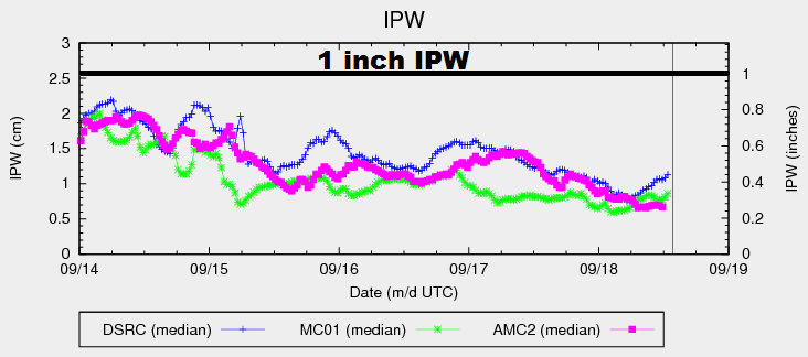
One look at the IPW graph below tells a big chunk of today’s weather story, showing just how dry the atmosphere has become in the last 24-48 hours. For today/tonight, ridging aloft will keep the atmosphere subdued across Colorado, resulting in a day of late-summer warmth and mostly sunny skies. High temperatures will nudge upward a few degrees from yesterday, and a few locations across eastern Colorado will flirt with 90 F. Additionally, with moisture bottoming out, and gusty winds expected across northern Colorado, Red Flag Warnings have been issued for portions of the Northeast Plains, Urban Corridor, Front Range, and Northern Mountains regions. Please visit your local NWS office website for more details.
Today’s Flood Threat Map
For more information on today’s flood threat, see the map below (hover over threat areas for more details). For Zone-Specific forecasts, jump below the map.

Zone-Specific Forecasts
Northeast Plains, Urban Corridor, Palmer Ridge, Southeast Plains, and Raton Ridge:
Sunny, dry, and hot is the main weather story today, with Red Flag Warnings issued for northern portions of the Northeast Plains and Urban Corridor. A few locations across the eastern plains will have high temperatures flirt with 90 F, mainly in the Arkansas River Valley.
Front Range, Southeast Mountains, Northern Mountains, Northwest Slope, Grand Valley, Central Mountains, San Juan Mountains, Southwest Slope, and San Luis Valley:
Mostly sunny and dry will be the name of the game today, with gusty winds expected across northern regions. Due to the drop in moisture, combined with the gusty winds, Red Flag Warnings are in effect for portions of the Northern Mountains and Front Range regions.