Issue Date: 9/20/2016
Issue Time: 9:16 AM
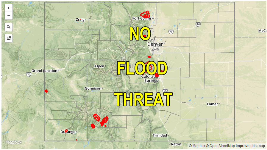
NO FLOOD THREAT IS FORECAST.
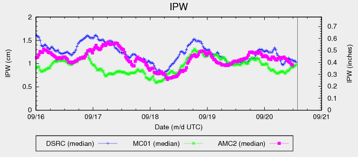
Cloud cover across the state has increased significantly since sunset last night due to mid- and high-level moisture streaming in from the southwest. Even with the increase in moisture, IPW values are still fairly meager, however, as evidenced in the IPW chart below. This is due to the low-levels remaining on the dry side, with most of the moisture residing 3 km (or more) above the ground. Eventually, low-level moisture will increase from the southwest across western Colorado, but this will hold off until the late evening hours tonight and into the early morning hours tomorrow. In the meantime, the lack of low-level moisture will fight precipitation chances throughout the day and into the evening hours. At best, isolated light sprinkles/showers, and perhaps a weak thunderstorm or two, are possible across the higher terrain along/west of the Continental Divide. Not much rainfall is expected. East of the Divide, increased cloud cover, dry conditions, and continued warmth will be the main weather story.
As alluded to above, moisture will increase during the late evening and early morning hours tomorrow, especially across western Colorado. This will result in the Wednesday portion of this forecast period (Midnight – 11 AM tomorrow) the most active, relatively speaking. An increase in shower coverage, with a few embedded thunderstorms, is expected across the High Country and Western Slope, with an isolated shower/weak storm spilling over into the Front Range and Southeast Mountains regions. Most precipitation is expected to remain light, with any thunderstorms producing brief periods of moderate rainfall. No flood threat will be issued, due to rain rates expected to remain well below thresholds. For more information on timing and rain rates, please see the zone-specific forecast discussions below.
Today’s Flood Threat Map
For more information on today’s flood threat, see the map below (hover over threat areas for more details). For Zone-Specific forecasts, jump below the map.

Zone-Specific Forecasts
Urban Corridor, Palmer Ridge, Northeast Plains, Raton Ridge and Southeast Plains:
Plenty of mid- and high-level clouds will be situated across the area today, with high temperatures expected to remain above normal, albeit a few degrees cooler than yesterday. No precipitation is expected for these regions, but a few streaks of virga may grace the sky during the morning hours tomorrow.
Front Range, Southeast Mountains, Northern Mountains, Northwest Slope, San Juan Mountains, Southwest Slope, San Luis Valley, Central Mountains, and Grand Valley:
Clouds are expected to increase throughout the day, with high temperatures expected to be a few degrees cooler than yesterday. A few light showers, and perhaps a weak thunderstorm or two, will pop up across areas along/west of the Continental Divide during the late afternoon/early evening hours, mainly south of I-70. Precipitation will generally be light, and not a cause for any flood threat issuance. During the late evening/overnight hours, low-level moisture will increase from the southwest. Activity will ramp up through tomorrow morning, with a couple isolated showers/weak storms spilling over into the Front Range and Southeast Mountains regions. Still, rain rates will remain below flash flood thresholds, so no flood threat will be issued. Maximum rain rates are as follows:
Front Range, Northern Mountains, Northwest Slope, San Luis Valley, Central Mountains, Grand Valley, and Southeast Mountains: 0.2-0.4 inches/hour
Southwest Slope and San Juan Mountains: 0.4-0.6 inches/hour
Timing: 3 PM – 11 AM