FTB 05-07-2017: Unsettled End to the Weekend

Issue Date: 5/7/2017
Issue Time: 9:40 AM

NO FLOOD THREAT IS FORECAST.

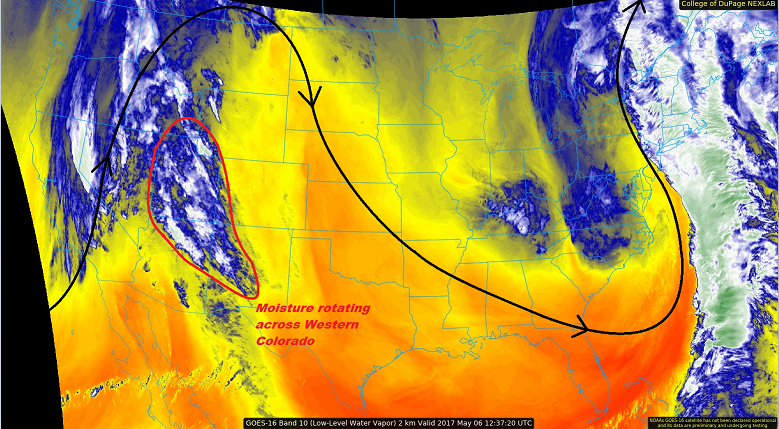
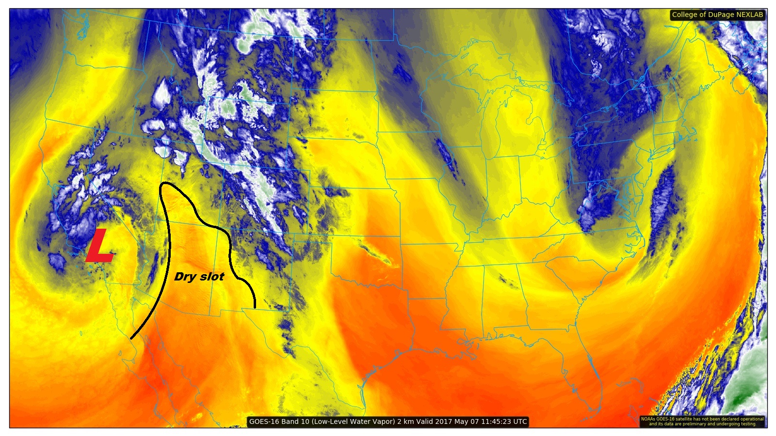
As the upper-low spins over southern California, and an upper-ride resides across the central US, moisture will be directed across Colorado today. This will lead to an unsettled day for the state with scattered showers and thunderstorms expected. The most coverage will occur over the high country, where orographic lift will combine with atmospheric support to drive showers/thunderstorms. The dry slot noted on the water vapor image below will work its way into western Colorado this evening/overnight, bringing showers/thunderstorms to an end from southwest to northeast.

The lower elevations of eastern Colorado will also get in on the action this afternoon/evening, as a passing shortwave disturbance, along with weak instability, will promote scattered showers/thunderstorms. Pea-sized hail will likely attend stronger thunderstorms, as well as brief periods of moderate rainfall. After the shortwave moves through, activity will clear out and dry/cool conditions will prevail overnight and into tomorrow morning. For more details, please see the zone-specific forecast discussions below.

Today’s Flood Threat Map

For more information on today’s flood threat, see the map below (hover over threat areas for more details). For Zone-Specific forecasts, jump below the map.

Flood Threat Legend

Zone-Specific Forecasts

Urban Corridor, Palmer Ridge, Northeast Plains, Southeast Plains, and Raton Ridge:

A few showers will begin to develop between 10 AM and Noon, followed by more rigorous development (including a few thunderstorms) after noon. Coverage of showers/storms will maximize around 6 PM, slowly reducing in number and exiting the state through the late evening hours. A few showers/thunderstorms will be ongoing across the eastern plains until Midnight or so. Maximum rain rates are as follows:

Urban Corridor, Palmer Ridge, and Raton Ride: 0.5-0.8 inches/hour
Northeast Plains and Southeast Plains: 0.8-1.2 inches/hour

Front Range and Southeast Mountains:

Scattered showers and a few thunderstorms are expected this afternoon and evening, resulting in mainly gusty winds and light rainfall. Brief periods of moderate rainfall, to the tune of 0.4-0.7 inches/hour, are expected underneath thunderstorms. These brief periods will result in minor ponding on roadways, but storm motions will be quick enough to avoid any potential flooding issues.

Timing: 11 AM – 10 PM

Northern Mountains, Northwest Slope, Central Mountains, Grand Valley, San Juan Mountains, San Luis Valley, and Southwest Slope:

Scattered showers, and a few embedded thunderstorms, are expected across these regions today. The best coverage will occur across the higher terrain, especially in the Central Mountains, Northern Mountains, and San Juan Mountains regions. Rain rates from showers will be light, to the tune of 0.2-0.4 inches/hour. Thunderstorms will produce brief periods of rainfall at 0.5-0.8 inches/hour, but storm motions are expected to be quick enough to avoid any potential flooding issues.

Timing: 11 AM – 10 PM

FTB 05-06-2017: Showers and a Few Thunderstorms Return

Issue Date: 5/6/2017
Issue Time: 8:30 AM

NO FLOOD THREAT IS FORECAST.

The high pressure ridge aloft that has kept Colorado dry the last two days is shifting eastward, allowing for the return of moisture from the south/southwest. This plume of low- and mid-level moisture is apparent in the water vapor image below (circled in red). This moisture, in concert with atmospheric lift, will result in scattered showers and a few thunderstorms over the high country & western slope today/tonight. Light rainfall and gusty winds will be the main impacts from any activity. For the lower elevations of eastern Colorado, dry conditions will prevail. A few mid- and high-level clouds will be present, but will be most numerous near the higher terrain.

Showers and thunderstorms will decay during the late evening hours as daytime heating wanes. A few isolated-to-widely scattered showers/thunderstorms will continue into the overnight hours, mainly along and west of the Continental Divide, as a mid-level disturbance rotates through the region. For more information, please see the zone-specific forecast discussions below.

Today’s Flood Threat Map

For more information on today’s flood threat, see the map below (hover over threat areas for more details). For Zone-Specific forecasts, jump below the map.

Flood Threat Legend

Zone-Specific Forecasts

Urban Corridor, Palmer Ridge, Northeast Plains, Southeast Plains, and Raton Ridge:

Mostly sunny and dry conditions will prevail today, with high temperatures well above average in the 70s and 80s. A few locations in the Arkansas River Valley will flirt with the 90° F mark. Mid- and high-level clouds will persist through the overnight hours, expanding their coverage a bit eastward over the plains.

Front Range and Southeast Mountains:

Mostly sunny conditions will prevail through the early afternoon, with clouds increasing over the higher terrain during the afternoon and evening hours. A few showers/thunderstorms are expected, with the main impacts of light rainfall and gusty winds. Some activity will continue overnight, but will be widely scattered. Maximum rain rates will be 0.4-0.6 inches/hour, but most rain rates will remain in the 0.2-0.4 inches/hour range.

Timing: 3 PM – 9 PM, with a few lingering showers/weak thunderstorms overnight.

Northern Mountains, Northwest Slope, Central Mountains, Grand Valley, San Juan Mountains, San Luis Valley, and Southwest Slope:

Scattered showers and thunderstorms are expected today/tonight, mainly over the higher terrain. Storm motions will generally be slow, and rain rates will generally be low. Gusty winds and rain rates around 0.1-0.3 inches/hour will be the main impacts. Brief periods of heavier rain may occur underneath thunderstorms to the tune of 0.3-0.5 inches/hour.

Timing: 1 PM – 11 PM, with widely scattered, lingering showers (and a few thunderstorms) continuing into the morning hours tomorrow.

FTB 05-05-2017: Another Dry Day Statewide

Issue Date: 5/5/2017
Issue Time: 8:35 AM

NO FLOOD THREAT IS FORECAST.

A strong high pressure ridge aloft, combined with dry air over the state, will lead to another sunny and pleasant day across Colorado. The few high clouds over the southeastern plains (shown in visible image below) will move out/dissipate over the next few hours. Aside from a few shallow, puffy clouds over the higher terrain this afternoon/evening, nothing but blue skies are expected. The weather will provide the perfect end to the work week.

Today’s Flood Threat Map

For more information on today’s flood threat, see the map below (hover over threat areas for more details). For Zone-Specific forecasts, jump below the map.

Flood Threat Legend

Zone-Specific Forecasts

Urban Corridor, Palmer Ridge, Northeast Plains, Southeast Plains, and Raton Ridge:

Sunny and dry conditions are expected today, with the few high clouds over the Southeast Plains exiting/dissipating by the early afternoon hours. High temperatures will be a few degrees warmer than yesterday, with a few locations flirting with 80° F.

Northern Mountains, Northwest Slope, Front Range, Southeast Mountains, San Juan Mountains, Southwest Slope, Central Mountains, Grand Valley, and San Luis Valley:

Aside from a few puffy clouds developing during the heat of the afternoon/early evening, nothing but sunshine and dry conditions are expected. High temperatures will be a few degrees warmer than yesterday, with lower valleys reaching into the low-to-mid 80s.

FTB 05-04-2017: Dry with Seasonal Temperatures

Issue Date: 5/4/2017
Issue Time: 8:40 AM

NO FLOOD THREAT IS FORECAST.

Strong high pressure ridging will build over the state today, resulting in what can be referred to as a “severe clear” day. Dry conditions will prevail as high temperatures push to near seasonal levels across Colorado. A few high-level clouds will return this afternoon/evening, but they won’t do anything other than provide something to look at in the sky.

Today’s Flood Threat Map

For more information on today’s flood threat, see the map below (hover over threat areas for more details). For Zone-Specific forecasts, jump below the map.

Flood Threat Legend

Zone-Specific Forecasts

Urban Corridor, Palmer Ridge, Northeast Plains, Southeast Plains, and Raton Ridge:

Sunny and dry conditions are expected today, with a few high clouds returning this evening. High temperatures will warm into the 60s/70s, so if you can, get out and enjoy the afternoon.

Northern Mountains, Northwest Slope, Front Range, Southeast Mountains, San Juan Mountains, Southwest Slope, Central Mountains, Grand Valley, and San Luis Valley:

Sunny and dry conditions are expected today. A few high clouds will return this afternoon/evening. High temperatures will be in the 60s/70s for lower elevations, with highs in the 30s/40s in the mountains.