Issue Date: 5/6/2017
Issue Time: 8:30 AM
NO FLOOD THREAT IS FORECAST.
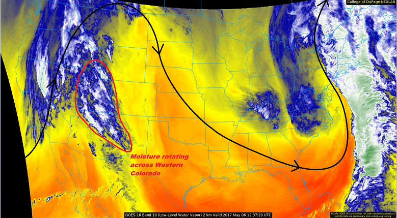
The high pressure ridge aloft that has kept Colorado dry the last two days is shifting eastward, allowing for the return of moisture from the south/southwest. This plume of low- and mid-level moisture is apparent in the water vapor image below (circled in red). This moisture, in concert with atmospheric lift, will result in scattered showers and a few thunderstorms over the high country & western slope today/tonight. Light rainfall and gusty winds will be the main impacts from any activity. For the lower elevations of eastern Colorado, dry conditions will prevail. A few mid- and high-level clouds will be present, but will be most numerous near the higher terrain.
Showers and thunderstorms will decay during the late evening hours as daytime heating wanes. A few isolated-to-widely scattered showers/thunderstorms will continue into the overnight hours, mainly along and west of the Continental Divide, as a mid-level disturbance rotates through the region. For more information, please see the zone-specific forecast discussions below.
Today’s Flood Threat Map
For more information on today’s flood threat, see the map below (hover over threat areas for more details). For Zone-Specific forecasts, jump below the map.

Zone-Specific Forecasts
Urban Corridor, Palmer Ridge, Northeast Plains, Southeast Plains, and Raton Ridge:
Mostly sunny and dry conditions will prevail today, with high temperatures well above average in the 70s and 80s. A few locations in the Arkansas River Valley will flirt with the 90° F mark. Mid- and high-level clouds will persist through the overnight hours, expanding their coverage a bit eastward over the plains.
Front Range and Southeast Mountains:
Mostly sunny conditions will prevail through the early afternoon, with clouds increasing over the higher terrain during the afternoon and evening hours. A few showers/thunderstorms are expected, with the main impacts of light rainfall and gusty winds. Some activity will continue overnight, but will be widely scattered. Maximum rain rates will be 0.4-0.6 inches/hour, but most rain rates will remain in the 0.2-0.4 inches/hour range.
Timing: 3 PM – 9 PM, with a few lingering showers/weak thunderstorms overnight.
Northern Mountains, Northwest Slope, Central Mountains, Grand Valley, San Juan Mountains, San Luis Valley, and Southwest Slope:
Scattered showers and thunderstorms are expected today/tonight, mainly over the higher terrain. Storm motions will generally be slow, and rain rates will generally be low. Gusty winds and rain rates around 0.1-0.3 inches/hour will be the main impacts. Brief periods of heavier rain may occur underneath thunderstorms to the tune of 0.3-0.5 inches/hour.
Timing: 1 PM – 11 PM, with widely scattered, lingering showers (and a few thunderstorms) continuing into the morning hours tomorrow.