FTB 07-04-2022: Rinse & Repeat Rainfall Pattern From Yesterday, But Downtick In Coverage For The 4th of July

Issue Date: Monday, July 4th, 2022
Issue Time: 9:40AM MDT

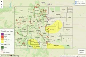
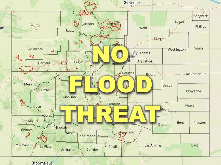
Flooding is NOT expected today
 Fire-Burn Forecast Summary: 2 burn areas under LOW threat; click HERE for more info

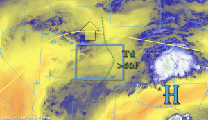
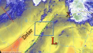
A happy 4th of July to everyone! A classic Colorado summer day is on tap with above average temperatures forecast out east and near normal to slightly below average temperatures forecast over western Colorado. Afternoon storms are expected to fire over the mountains in a similar manner to yesterday; however, the incoming trough off the west coast has helped produce a drier southwesterly flow over the western and northern portions of the state. That boundary is marked in green in the water vapor imagery below, which for the forecast, translates to slightly less coverage of storms when compared to yesterday. PW was still measured at 0.91 inches at Grand Junction this morning, which is quite moist, but a lot of dry air was noted above ~600mb. This, paired with the faster steering flows over the area again, should help to temper rainfall activity and the flood threat today. The isolated, but stronger storms that develop will again be capable of producing small hail, strong outflow winds and plenty of lightning over the area.

Switching over to eastern Colorado, PW at Denver was measured at 0.69 inches, so right around average. Dew points were also noted around 50°F across the lower elevations, but increasing westerly flow aloft will likely mix out some of this shallow moisture as the day progresses. At the surface, a trough axis was noted over the plains this morning, oriented from southwest to northeast. This should help keep upslope rather weak this afternoon and prevent strong moisture advection back to the west. Thus, the scattered storms that develop should pose less of a flood risk today even though steering flow remains rather weak over this area. As storms move off the mountains into the I-25 Corridor, gusty outflow winds and dangerous lightning will continue to be the main threats. Moderate rainfall will be possible under the more stationary storms, which will be most likely along and near the elevated ridges, but rain rates are expected to stay under flood threat criteria. Thus, there is NO flood threat issued today.

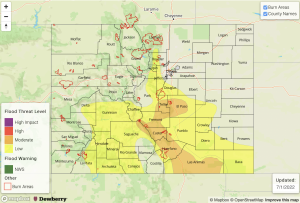
Today’s Flood Threat Map

For more information on today’s flood threat, see the map below. If there is a threat, hover over the threat areas for more details, and click on burn areas to learn more about them. For Zone-Specific forecasts, scroll below the threat map.
Zone-Specific Forecasts:

Front Range, Central Mountains, San Juan Mountains, Northern Mountains & Southeast Mountains:

Widely scattered to scattered storms are forecast today with the best coverage of thunderstorms over the northern San Juan Mountains, Central Mountains and southern Front Range. Max 1-hour rain rates up to 0.85 inches will be possible along with isolated storm totals up to 1.25 inches, which will be most likely to occur over the northern San Juan Mountains and near the Continental Divide. In addition to dangerous lightning, strong thunderstorms will also be capable of producing small hail and brief, gusty wind. Most activity will end in the late evening hours, but some lingering rainfall will again be possible tonight (south). Flooding is NOT expected today.

Primetime: 1PM to 10:30PM

Raton Ridge, Palmer Ridge, Urban Corridor, Northeast Plains & Southeast Plains:

Steering flows will likely push the scattered storms into these forecast zones by mid-afternoon favoring the Palmer Ridge and northwards for lasting rainfall activity. Max 1-hour rainfall rates up to 0.75 inches will be possible along with isolated storms totals up to 1.1 inches, but most storms will produce storm totals under 0.40 inches. The stronger storms also have the potential to produce brief, outflow winds up to 40 mph.

Primetime: 1:30PM to 11PM 

Northwest Slope, Southwest Slope, Grand Valley & San Luis Valley:

More isolated storms are forecast to develop over the elevated ridges and mesas this afternoon. Storms may produce some windy conditions as well as dangerous lightning. Max 30-minute rain rates up to 0.5 inches will be possible, so flooding is NOT expected.

Primetime: Noon to 9PM
FTB 07-03-2022: Scattered to Numerous Storms Return To The High Terrains With Monsoon Moisture Overhead

Issue Date: Sunday, July 3rd, 2022
Issue Time: 10:10AM MDT

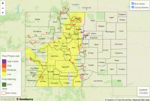
— A LOW flood threat has been issued for the Central Mountains, San Juan Mountains, Front Range and portions of the Northern Mountains, Grand Valley, Southwest Slope, San Luis Valley and Southeast Mountains
Fire-Burn Forecast Summary: 5 burn areas under MODERATE threat, 3 burn areas under LOW threat; click HERE for more info

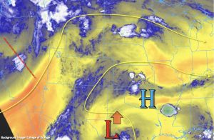
As far as today’s synoptic setup, a northward moving Low from our south and an incoming trough off the west coast will work together to hold the monsoon moisture plume over the state. PW has mostly risen over the last 24-hours, and it was measured at 0.98 inches in Grand Junction this morning. There has been some drying over the northeast corner of the state, which is shown by Denver’s morning PW value measured at 0.77 inches. Southwesterly steering flows should increase with the incoming trough, especially over western Colorado, which should somewhat limit the flood threat over that area. However, training storms further south across the high terrains are likely to boost local totals with 2 to 3 hours of rain forecast for the rest of today. Currently, there are some light to moderate scattered showers occurring over the San Juan Mountains associated with some mid-level lift over the area. As this set of storms lifts northeast expect some intensification with the increase in daytime heating and also expansion of the rainfall coverage. With the moisture plume over the area and longer duration rainfall forecast, this could cause some isolated flooding issues over the San Juan and Southeast Mountains where there is embedded convection, so a LOW flood threat has been issued.

Additional scattered storms are forecast to develop over the central and northern high terrains by early afternoon. While the coverage of storms will be less for this area, local, heavy rainfall and training storms will still be possible, which could lead to local flooding issues under the stronger thunderstorms. Thus, the LOW flood threat has been extended northwards for areas along and near the Continental Divide and the elevated plateaus/mesas over western Colorado. The flood threat decreases rapidly this evening with the setting sun, although some light rainfall could linger over the mountains tonight.

Today’s Flood Threat Map

For more information on today’s flood threat, see the map below. If there is a threat, hover over the threat areas for more details, and click on burn areas to learn more about them. For Zone-Specific forecasts, scroll below the threat map.

Zone-Specific Forecasts:

Front Range, Central Mountains, Northern Mountains, Urban Corridor, Northwest Slope & Grand Valley:

Scattered storms are forecast today with max 1-hour rain rates up to 1.25 inches possible. A couple rounds of rainfall or areas with training storms could accumulate isolated amounts up to 1.75 inches. This could cause localized flooding issues on roads/low-lying areas as well as isolated mud and debris flows over steeper terrains. Stronger thunderstorms may produce brief windy conditions or small hail. A LOW flood threat has been issued.

Primetime: 12:30PM to 11PM

San Juan Mountains, Southwest Slope, San Luis Valley & Southeast Mountains:

Numerous storms are forecast to develop by early this afternoon, and 1-hour rain rates up to 1.5 inches will be possible. Training and slow-moving storm complexes with local embedded convection could cause local totals reach 2.25 inches over a 2-to-3-hour rainfall period. This could cause local flash flooding issues as well as isolated mud flows and debris slides over steeper terrains. A LOW flood threat has been issued that concludes later tonight, although some light showers may linger over the high terrains through tomorrow morning.

Primetime: Ongoing to 3AM

Raton Ridge, Palmer Ridge, Northeast Plains & Southeast Plains:

Isolated storms may spill into the western portions of these forecast zones with the southwest steering flow. Isolated develop is also likely along a surface trough over the Southeast Plains and storms may move off the Cheyenne Ridge into the Northeast Plains later tonight. Because it is drier over northwest Colorado, storms should be more isolated over this area and may produce some strong wind. Max 1-hour rain rates up to 0.9 inches will be possible with most storms producing totals under 0.75 inches. Hail and wind may accompany the stronger thunderstorms out east. Flooding is NOT expected today.

Primetime: 1PM to 9PM

FTB 07-02-2022: Slight Drying Trend, But Scattered Storms Return To The Forecast

Issue Date: Saturday, July 2nd, 2022
Issue Time: 9:45AM MDT

— A LOW flood threat has been issued for the Raton Ridge, Palmer Ridge and portions of the Urban Corridor, Front Range and San Juan Mountains
 Fire-Burn Forecast Summary: 4 burn areas under MODERATE threat, 4 burn areas under LOW threat; click HERE for more info

Some drying has occurred across the state since yesterday, which can be seen by the increase of yellow in the water vapor imagery below. PW at Grand Junction has dropped to 0.91 inches, and over Denver, it has dropped to 0.83 inches. However, these values are still quite above normal, which means there will be plenty of moisture for another round of storms today. Dew points are still quite high over eastern Colorado, but across the southern border back west, the higher dew points should sit just south of the state. As the ridge builds northward today, there should be a slight increase in the afternoon high temperatures. This will also create a little more subsidence, or sinking motion, over the state and without any distinctive shortwave moving overhead, storms should be more scattered when compared to yesterday.

Clockwise storm motion around the High pressure means storms that develop over the mountains may spill into the adjacent plains this afternoon. These storms are most likely to continue over the three elevated ridges, and a stray storm or two may move across the border into the Northeast Plains this evening. With storm motion continuing to be on the slower side under the current synoptic setup, isolated, heavy rainfall may be possible under the stronger storm cores. This heavier rainfall potential will be over the elevated ridges (east) where enhanced convergence is likely to occur with slightly better moisture. The other area to watch will be over the southern San Juan Mountains where a couple rounds of storms over the same area could cause local flooding issues. Since the threat will be more isolated in nature today, only a LOW flood threat has been issued.

Today’s Flood Threat Map

For more information on today’s flood threat, see the map below. If there is a threat, hover over the threat areas for more details, and click on burn areas to learn more about them. For Zone-Specific forecasts, scroll below the threat map.

Zone-Specific Forecasts:

Front Range, Urban Corridor, Palmer Ridge, Northeast Plains, Raton Ridge, Southeast Mountains & Southeast Plains:

Isolated max 1-hour rain rates up to 1.5 inches (north) and 1.25 inches (south) will be possible over the elevated ridges. This could cause local flooding issues on roads as well as field ponding, so a LOW flood threat has been issued. A storm may sneak into the far Northeast Plains this evening off the Cheyenne Ridge, and produce max 1-hour rain rates up to 1.5 inches if this occurs further east. If any stronger thunderstorms develop over the adjacent plains, they may produce some small hail and brief outflow winds. Generally, rain rates under the stronger storms over the Front Range and Southeast Mountains will be around 0.75 inches today.

Primetime: Noon to 9PM (south); 2PM to 11PM (north/central) 

San Juan Mountains, Northern Mountains, Central Mountains, Northwest Slope, Grand Valley, Southwest Slope & San Luis Valley:

Storms will be more widely scattered over the northern and central high terrains with more scattered storms forecast south. Max 1-hour rain rates over the central and northern portions of these zones could reach up to 0.50 inches with brief, strong outflow winds possible. Further south, a few rounds of rainfall over the same location could produce local totals up to 1.5 inches. A LOW flood threat has been issued over the southern San Juan Mountains for this reason where increased runoff and isolated mud flows and debris slides will be possible. Another round of weak showers may move into the area early tomorrow morning, but most storms should end a couple of hours after sundown tonight.

Primetime: 11AM to 11PM

FTB 07-01-2022: Heavy Rainfall Once Again Possible For Mainly Central/Southern Areas

Issue Date: Friday, July 1st, 2022
Issue Time: 10:15 AM MDT

— A MODERATE flood threat has been issued for portions of the Palmer Ridge, Front Range, Southeast Mountains and Raton Ridge
— A LOW flood threat has been issued for portions of Central Mountains, San Juan Mountains and Southeast Plains
— Fire-Burn Forecast Summary: 6 burn areas under MODERATE threat, 4 burn areas under LOW threat; click HERE for more info

Plenty of monsoonal moisture continues to hang around Colorado as we start July. This morning’s PW came in at 0.93 inches at Denver and 0.99 inches at Grand Junction, well above seasonal normal. The moisture profile was equally distributed throughout the atmosphere, which is supportive of heavy rainfall potential. Dewpoint temperatures have increase statewide, but especially over central and southeast areas as weak cool front has trekked slowly southward overnight.

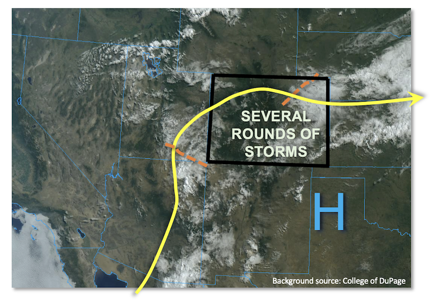
As shown in the satellite image, below, today is a type of day where the devil is in the details. In the mid-levels of the atmosphere, a couple of weak disturbances were noted both over eastern Colorado and back west towards the Four Corners. These will slowly rotate clockwise across Colorado, providing some organization to storms firing initially off the higher terrain. At the surface, the passage of a weak cool front will likely limit rainfall coverage over northeast Colorado as weak subsidence and limited instability is expected. However, a few late evening storms (possibly severe) could move through the area with brief moderate/heavy rainfall. But the more problematic areas today will be over the central and southern higher terrain where plenty of moisture, the aforementioned cool front boundary and morning sunshine will boost instability up to 1,800 J/kg CAPE locally. With slow storm motion in the 15-20 mph range, heavy rainfall will be possible. In addition, if initial storms fire early enough in the afternoon (as expected), at least one more round of later storms could occur as the atmosphere recovers instability. Thus, in addition to the usual potential of 30-60 minute heavy rainfall capable of flash flooding, there is the possibility of multiple rounds of heavy rainfall over a 3-6 hour period. Overall, this in addition to the antecedent precipitation, warrants a MODERATE flood threat for mainly the southern foothills and higher terrain, with a LOW flood threat over surrounding areas. Activity should subside quickly after sunset for most areas, but a few storm complexes could survive into the early overnight hours eastward over the plains as the nocturnal low-level jet arrives.

Today’s Flood Threat Map

For more information on today’s flood threat, see the map below. If there is a threat, hover over the threat areas for more details, and click on burn areas to learn more about them. For Zone-Specific forecasts, scroll below the threat map.

Zone-Specific Forecasts:

Raton Ridge, Southeast Mountains, Front Range, Palmer Ridge, Northeast Plains, Southeast Plains & Urban Corridor:

Variable cloudiness and cool with scattered to numerous showers and thunderstorms expected this afternoon and evening. Highest storm coverage will be over the higher terrain and foothills as well as towards the New Mexico border. Max 30-minute rain rates up to 1.8 inches (east) and 1.2 inches (west) with max 1-hour rainfall up to 2.5 inches (east) and 1.8 inches (west). Up to 2.5 inches of rainfall in 3-hours is expected over parts of the Palmer Ridge, Southeast Mountains and Raton Ridge as multiple rounds of storms should move through the area throughout the day. A MODERATE flood threat has been posted for parts of the Palmer Ridge, Southeast Mountains and Raton Ridge with a LOW flood threat for surrounding areas. Isolated flash flooding, debris slides and mud flows are possible over steeper terrain, with flash flooding being the primary hazard over the plains.

Primetime (east): 2PM through 2AM

Primetime (west): 12PM through 10PM

San Juan Mountains, Central Mountains, Central Mountains, Grand Valley, Southwest Slope, San Luis Valley & Northwest Slope:

Partly cloudy early then widely scattered to numerous shower and storms with highest coverage towards the south. Max 30-minute rate rates up to 0.9 inches with max 1-hour rainfall up to 1.2 inches. Isolated flash flooding, debris slides and mud flows possible over steeper terrain. A LOW flood threat has been posted for southern portions of the region.

Primetime: 12PM through 10PM