Issue Date: Sunday, July 3rd, 2022
Issue Time: 10:10AM MDT
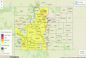
— A LOW flood threat has been issued for the Central Mountains, San Juan Mountains, Front Range and portions of the Northern Mountains, Grand Valley, Southwest Slope, San Luis Valley and Southeast Mountains
— Fire-Burn Forecast Summary: 5 burn areas under MODERATE threat, 3 burn areas under LOW threat; click HERE for more info
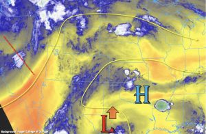
As far as today’s synoptic setup, a northward moving Low from our south and an incoming trough off the west coast will work together to hold the monsoon moisture plume over the state. PW has mostly risen over the last 24-hours, and it was measured at 0.98 inches in Grand Junction this morning. There has been some drying over the northeast corner of the state, which is shown by Denver’s morning PW value measured at 0.77 inches. Southwesterly steering flows should increase with the incoming trough, especially over western Colorado, which should somewhat limit the flood threat over that area. However, training storms further south across the high terrains are likely to boost local totals with 2 to 3 hours of rain forecast for the rest of today. Currently, there are some light to moderate scattered showers occurring over the San Juan Mountains associated with some mid-level lift over the area. As this set of storms lifts northeast expect some intensification with the increase in daytime heating and also expansion of the rainfall coverage. With the moisture plume over the area and longer duration rainfall forecast, this could cause some isolated flooding issues over the San Juan and Southeast Mountains where there is embedded convection, so a LOW flood threat has been issued.
Additional scattered storms are forecast to develop over the central and northern high terrains by early afternoon. While the coverage of storms will be less for this area, local, heavy rainfall and training storms will still be possible, which could lead to local flooding issues under the stronger thunderstorms. Thus, the LOW flood threat has been extended northwards for areas along and near the Continental Divide and the elevated plateaus/mesas over western Colorado. The flood threat decreases rapidly this evening with the setting sun, although some light rainfall could linger over the mountains tonight.
Today’s Flood Threat Map
For more information on today’s flood threat, see the map below. If there is a threat, hover over the threat areas for more details, and click on burn areas to learn more about them. For Zone-Specific forecasts, scroll below the threat map.
Zone-Specific Forecasts:
Front Range, Central Mountains, Northern Mountains, Urban Corridor, Northwest Slope & Grand Valley:
Scattered storms are forecast today with max 1-hour rain rates up to 1.25 inches possible. A couple rounds of rainfall or areas with training storms could accumulate isolated amounts up to 1.75 inches. This could cause localized flooding issues on roads/low-lying areas as well as isolated mud and debris flows over steeper terrains. Stronger thunderstorms may produce brief windy conditions or small hail. A LOW flood threat has been issued.
Primetime: 12:30PM to 11PM
San Juan Mountains, Southwest Slope, San Luis Valley & Southeast Mountains:
Numerous storms are forecast to develop by early this afternoon, and 1-hour rain rates up to 1.5 inches will be possible. Training and slow-moving storm complexes with local embedded convection could cause local totals reach 2.25 inches over a 2-to-3-hour rainfall period. This could cause local flash flooding issues as well as isolated mud flows and debris slides over steeper terrains. A LOW flood threat has been issued that concludes later tonight, although some light showers may linger over the high terrains through tomorrow morning.
Primetime: Ongoing to 3AM
Raton Ridge, Palmer Ridge, Northeast Plains & Southeast Plains:
Isolated storms may spill into the western portions of these forecast zones with the southwest steering flow. Isolated develop is also likely along a surface trough over the Southeast Plains and storms may move off the Cheyenne Ridge into the Northeast Plains later tonight. Because it is drier over northwest Colorado, storms should be more isolated over this area and may produce some strong wind. Max 1-hour rain rates up to 0.9 inches will be possible with most storms producing totals under 0.75 inches. Hail and wind may accompany the stronger thunderstorms out east. Flooding is NOT expected today.
Primetime: 1PM to 9PM

