Issue Date: Friday, July 1st, 2022
Issue Time: 10:15 AM MDT
— A MODERATE flood threat has been issued for portions of the Palmer Ridge, Front Range, Southeast Mountains and Raton Ridge
— A LOW flood threat has been issued for portions of Central Mountains, San Juan Mountains and Southeast Plains
— Fire-Burn Forecast Summary: 6 burn areas under MODERATE threat, 4 burn areas under LOW threat; click HERE for more info
Plenty of monsoonal moisture continues to hang around Colorado as we start July. This morning’s PW came in at 0.93 inches at Denver and 0.99 inches at Grand Junction, well above seasonal normal. The moisture profile was equally distributed throughout the atmosphere, which is supportive of heavy rainfall potential. Dewpoint temperatures have increase statewide, but especially over central and southeast areas as weak cool front has trekked slowly southward overnight.
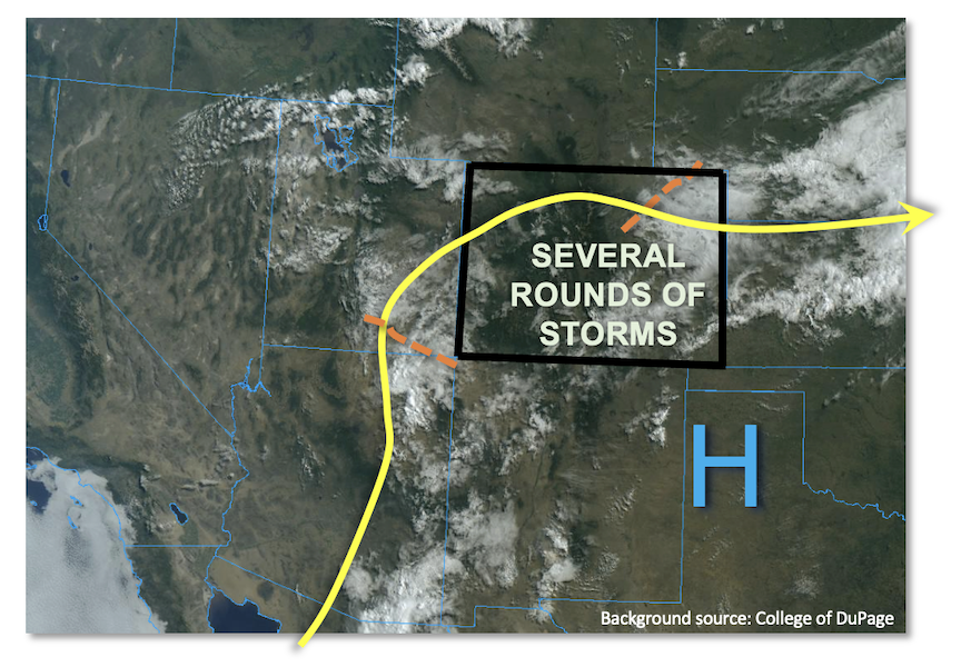
As shown in the satellite image, below, today is a type of day where the devil is in the details. In the mid-levels of the atmosphere, a couple of weak disturbances were noted both over eastern Colorado and back west towards the Four Corners. These will slowly rotate clockwise across Colorado, providing some organization to storms firing initially off the higher terrain. At the surface, the passage of a weak cool front will likely limit rainfall coverage over northeast Colorado as weak subsidence and limited instability is expected. However, a few late evening storms (possibly severe) could move through the area with brief moderate/heavy rainfall. But the more problematic areas today will be over the central and southern higher terrain where plenty of moisture, the aforementioned cool front boundary and morning sunshine will boost instability up to 1,800 J/kg CAPE locally. With slow storm motion in the 15-20 mph range, heavy rainfall will be possible. In addition, if initial storms fire early enough in the afternoon (as expected), at least one more round of later storms could occur as the atmosphere recovers instability. Thus, in addition to the usual potential of 30-60 minute heavy rainfall capable of flash flooding, there is the possibility of multiple rounds of heavy rainfall over a 3-6 hour period. Overall, this in addition to the antecedent precipitation, warrants a MODERATE flood threat for mainly the southern foothills and higher terrain, with a LOW flood threat over surrounding areas. Activity should subside quickly after sunset for most areas, but a few storm complexes could survive into the early overnight hours eastward over the plains as the nocturnal low-level jet arrives.
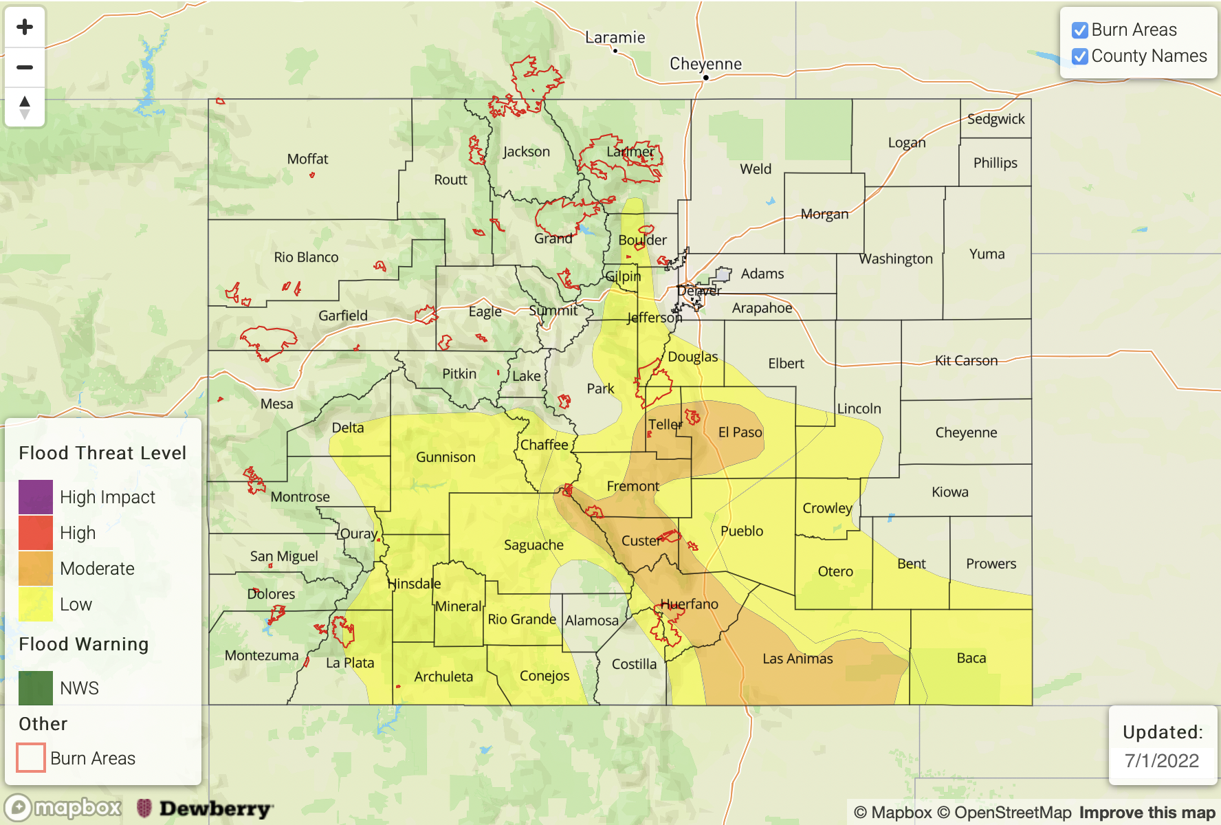
Today’s Flood Threat Map
For more information on today’s flood threat, see the map below. If there is a threat, hover over the threat areas for more details, and click on burn areas to learn more about them. For Zone-Specific forecasts, scroll below the threat map.
Zone-Specific Forecasts:
Raton Ridge, Southeast Mountains, Front Range, Palmer Ridge, Northeast Plains, Southeast Plains & Urban Corridor:
Variable cloudiness and cool with scattered to numerous showers and thunderstorms expected this afternoon and evening. Highest storm coverage will be over the higher terrain and foothills as well as towards the New Mexico border. Max 30-minute rain rates up to 1.8 inches (east) and 1.2 inches (west) with max 1-hour rainfall up to 2.5 inches (east) and 1.8 inches (west). Up to 2.5 inches of rainfall in 3-hours is expected over parts of the Palmer Ridge, Southeast Mountains and Raton Ridge as multiple rounds of storms should move through the area throughout the day. A MODERATE flood threat has been posted for parts of the Palmer Ridge, Southeast Mountains and Raton Ridge with a LOW flood threat for surrounding areas. Isolated flash flooding, debris slides and mud flows are possible over steeper terrain, with flash flooding being the primary hazard over the plains.
Primetime (east): 2PM through 2AM
Primetime (west): 12PM through 10PM
San Juan Mountains, Central Mountains, Central Mountains, Grand Valley, Southwest Slope, San Luis Valley & Northwest Slope:
Partly cloudy early then widely scattered to numerous shower and storms with highest coverage towards the south. Max 30-minute rate rates up to 0.9 inches with max 1-hour rainfall up to 1.2 inches. Isolated flash flooding, debris slides and mud flows possible over steeper terrain. A LOW flood threat has been posted for southern portions of the region.
Primetime: 12PM through 10PM