Issue Date: Saturday, July 2nd, 2022
Issue Time: 9:45AM MDT
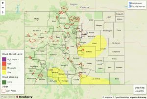
— A LOW flood threat has been issued for the Raton Ridge, Palmer Ridge and portions of the Urban Corridor, Front Range and San Juan Mountains
— Fire-Burn Forecast Summary: 4 burn areas under MODERATE threat, 4 burn areas under LOW threat; click HERE for more info
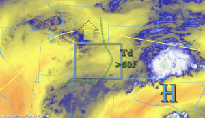
Some drying has occurred across the state since yesterday, which can be seen by the increase of yellow in the water vapor imagery below. PW at Grand Junction has dropped to 0.91 inches, and over Denver, it has dropped to 0.83 inches. However, these values are still quite above normal, which means there will be plenty of moisture for another round of storms today. Dew points are still quite high over eastern Colorado, but across the southern border back west, the higher dew points should sit just south of the state. As the ridge builds northward today, there should be a slight increase in the afternoon high temperatures. This will also create a little more subsidence, or sinking motion, over the state and without any distinctive shortwave moving overhead, storms should be more scattered when compared to yesterday.
Clockwise storm motion around the High pressure means storms that develop over the mountains may spill into the adjacent plains this afternoon. These storms are most likely to continue over the three elevated ridges, and a stray storm or two may move across the border into the Northeast Plains this evening. With storm motion continuing to be on the slower side under the current synoptic setup, isolated, heavy rainfall may be possible under the stronger storm cores. This heavier rainfall potential will be over the elevated ridges (east) where enhanced convergence is likely to occur with slightly better moisture. The other area to watch will be over the southern San Juan Mountains where a couple rounds of storms over the same area could cause local flooding issues. Since the threat will be more isolated in nature today, only a LOW flood threat has been issued.
Today’s Flood Threat Map
For more information on today’s flood threat, see the map below. If there is a threat, hover over the threat areas for more details, and click on burn areas to learn more about them. For Zone-Specific forecasts, scroll below the threat map.
Zone-Specific Forecasts:
Front Range, Urban Corridor, Palmer Ridge, Northeast Plains, Raton Ridge, Southeast Mountains & Southeast Plains:
Isolated max 1-hour rain rates up to 1.5 inches (north) and 1.25 inches (south) will be possible over the elevated ridges. This could cause local flooding issues on roads as well as field ponding, so a LOW flood threat has been issued. A storm may sneak into the far Northeast Plains this evening off the Cheyenne Ridge, and produce max 1-hour rain rates up to 1.5 inches if this occurs further east. If any stronger thunderstorms develop over the adjacent plains, they may produce some small hail and brief outflow winds. Generally, rain rates under the stronger storms over the Front Range and Southeast Mountains will be around 0.75 inches today.
Primetime: Noon to 9PM (south); 2PM to 11PM (north/central)
San Juan Mountains, Northern Mountains, Central Mountains, Northwest Slope, Grand Valley, Southwest Slope & San Luis Valley:
Storms will be more widely scattered over the northern and central high terrains with more scattered storms forecast south. Max 1-hour rain rates over the central and northern portions of these zones could reach up to 0.50 inches with brief, strong outflow winds possible. Further south, a few rounds of rainfall over the same location could produce local totals up to 1.5 inches. A LOW flood threat has been issued over the southern San Juan Mountains for this reason where increased runoff and isolated mud flows and debris slides will be possible. Another round of weak showers may move into the area early tomorrow morning, but most storms should end a couple of hours after sundown tonight.
Primetime: 11AM to 11PM

