Issue Date: Friday, July 8th, 2022
Issue Time: 10:35 AM MDT
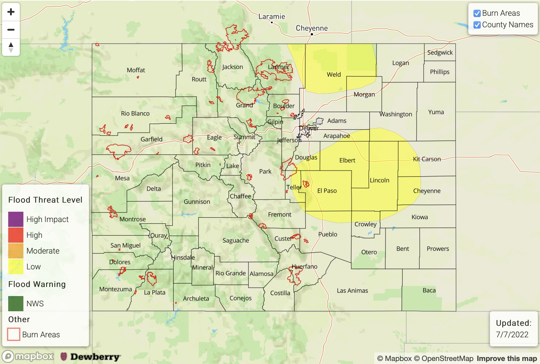
— A LOW flood threat has been issued for portions of the Palmer Ridge, Northeast Plains, and Southeast Plains
— Fire-Burn Forecast Summary: 2 burn areas under LOW threat, click HERE for more info
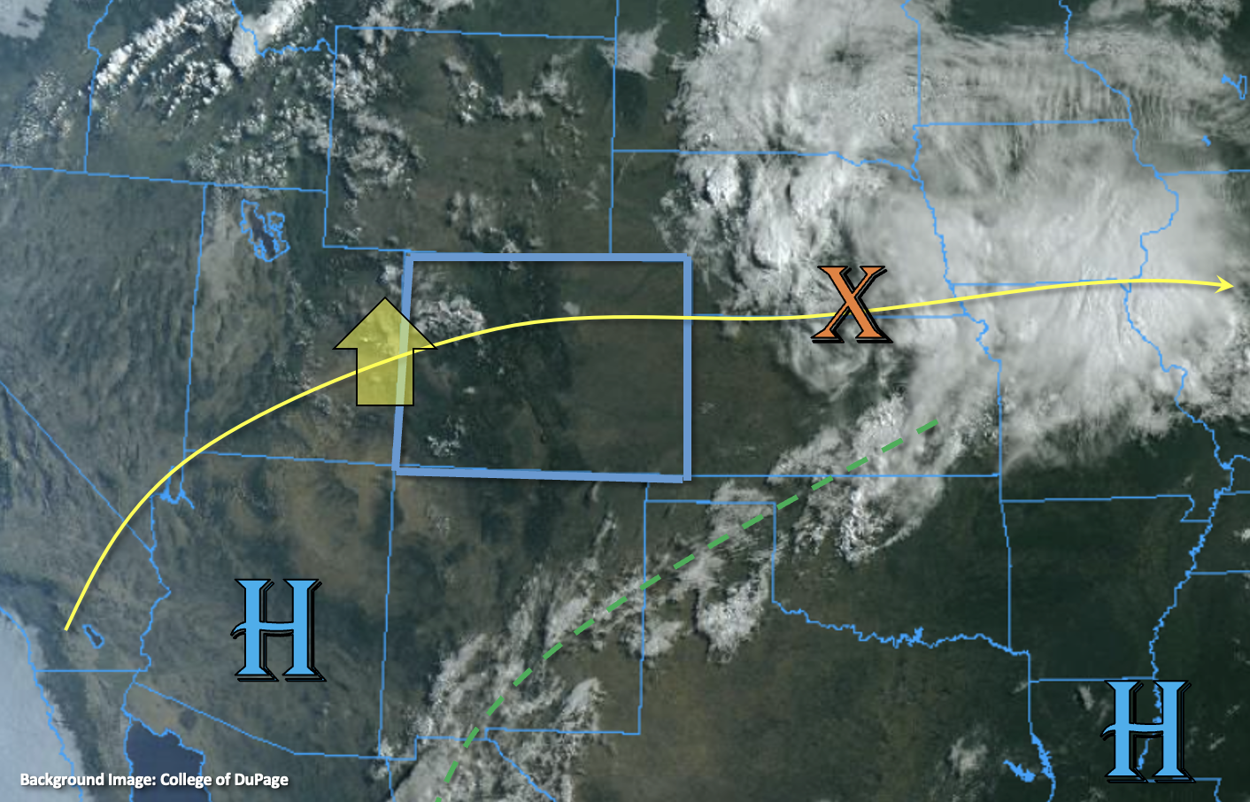
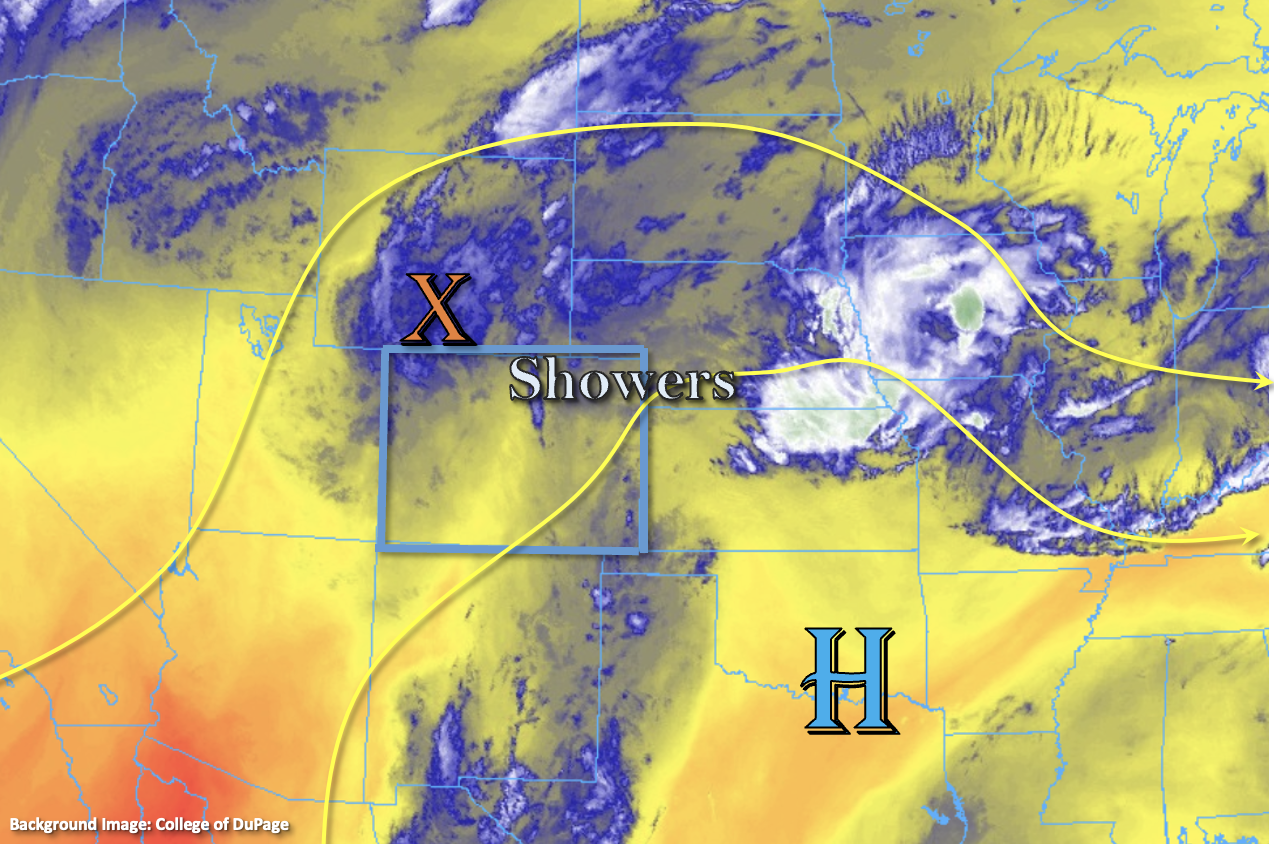
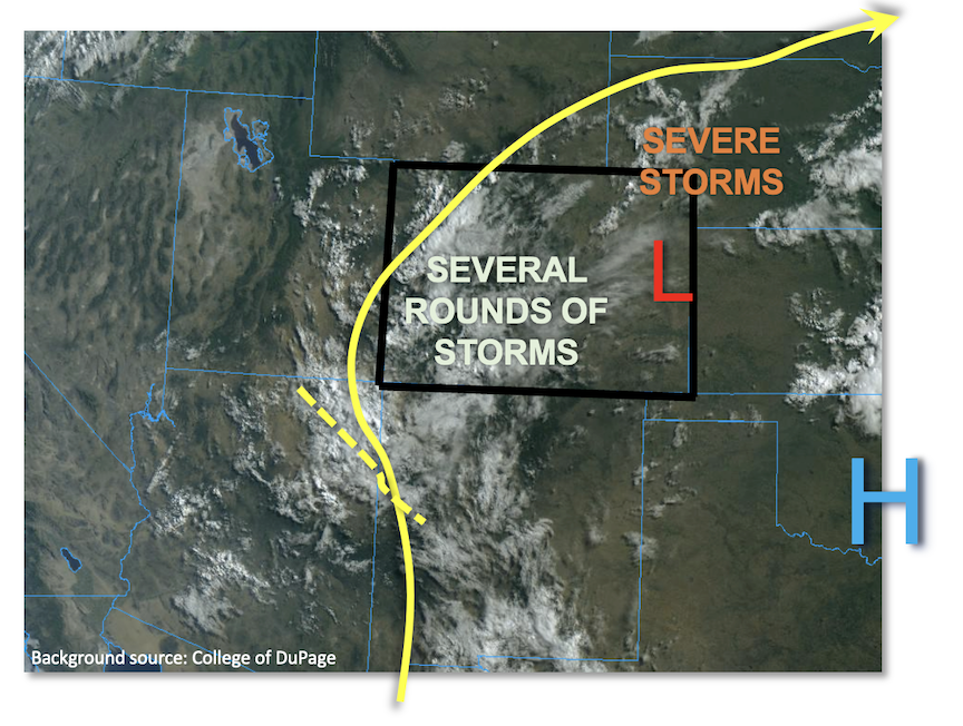
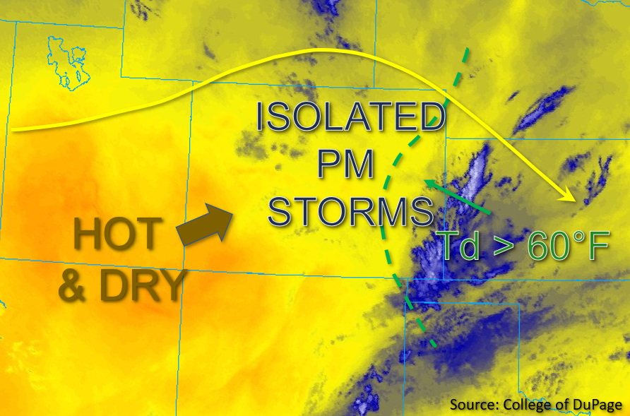
As a ridge of high pressure continues to build overhead today, subsidence and associated drying are expected across the state along with an increase in temperatures to several degrees above climatological average. A subtle shortwave is expected to move southeast across eastern Colorado and provide some added midlevel energy across the area later today. Over the eastern Northeast and Southeast Plains, residual moisture is expected to be suppressed in place due to the subsidence aloft. This afternoon, upslope flow is expected to steadily increase and reinforce or even increase moisture slightly over the Eastern Plains. This in conjunction with the aforementioned midlevel energy should provide weak convergence over the Palmer Ridge and Southeast Mountains. While some mixing out of boundary layer moisture is anticipated over the mountains and Urban Corridor, PW over 1 inch and dew points in the upper 50s to low 60s°F are forecast to remain in place across the Eastern Plains throughout the day, as shown in the visible satellite image below.
Given that instability is forecast to increase to 2700 to 3000 J/kg across eastern Colorado this afternoon, there should be enough dynamic lift for a few isolated storms to develop over the Palmer Ridge and Southeast Mountains initially, before moving off to the Northeast and Southeast Plains and Raton Ridge. These isolated storms will be capable of producing briefly heavy rainfall just above flood threshold over the eastern Palmer Ridge, as well as the far eastern Northeast and Southeast Plains, where soils are likely saturated as a result of the last two days of rainfall. As such, a LOW flood threat has been issued for the eastern Palmer Ridge, as well as portions of the Northeast and Southeast Plains where isolated 2 to 3-hour storm totals of up to 2 inches are possible.
Western Colorado is already under the influence of the drying trend as PW in Grand Junction this morning was measured to be only 0.48 inches, which is a stark decrease from yesterday’s value. Boundary layer moisture is forecast to continue to decrease rapidly throughout the day across the western half of the state, with dew points expected to drop from the upper 30s°F this morning to the teens and 20s°F by this afternoon. No meaningful precipitation is expected, therefore NO flooding is expected for western Colorado today.
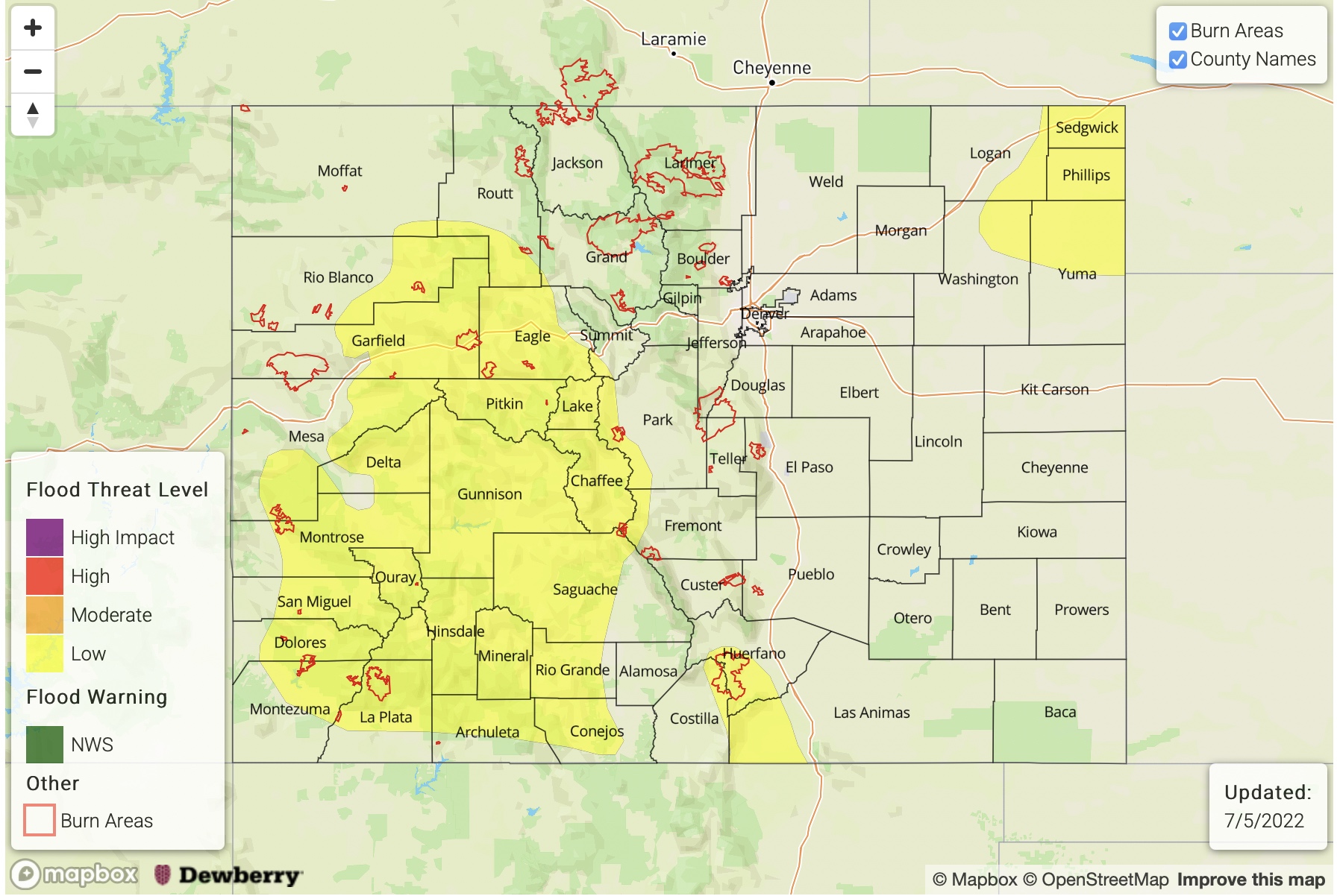
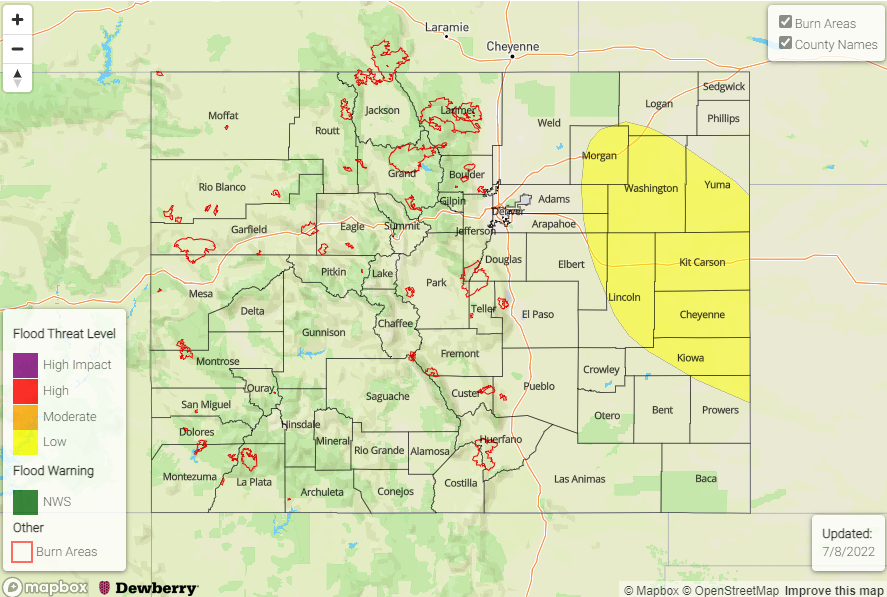
Today’s Flood Threat Map
For more information on today’s flood threat, see the map below. If there is a threat, hover over the threat areas for more details, and click on burn areas to learn more about them. For Zone-Specific forecasts, scroll below the threat map.
Zone-Specific Forecasts:
Front Range, Urban Corridor, Northeast Plains, Palmer Ridge, Southeast Plains, Raton Ridge & Southeast Mountains:
This morning, clear skies and pleasant temperatures are expected to quickly warm into the upper 80s to low 90s°F today. A few rounds of isolated storms are expected to develop initially over the Palmer Ridge and Southeast Mountains, and then propagate eastward onto the adjacent plains this afternoon. Storms that do form are expected to be brief in nature, though isolated heavy rainfall is possible with the more intense storms. Isolated 1 to 2-hour storm totals up to 1.5 inches are possible over the eastern Palmer Ridge, and 1.75 inches to isolated totals up to 2 inches are possible over a 1 to 2-hour period across the eastern Northeast and Southeast Plains; as such, a LOW flood threat has been issued for these zones.
Over the Southeast Mountains, isolated rain totals of 0.5 inches are possible, with 0.75 inches of rainfall possible over the Raton Ridge. A few isolated light showers are possible over the Front Range mountains as well, where max 1-hour rain rates up to 0.5 inches could occur with storms that may briefly intensify over the mountains. However, moisture is more negligible over these areas any storms that do form should be brief and relatively low in intensity. NO flooding is expected over these zones.
Primetime: 2PM to 9PM
Northwest Slope, Northern Mountains, Grand Valley, Central Mountains, Southwest Slope, San Juan Mountains & San Luis Valley:
A clear and sunny day is expected for the western half of the state today as any residual moisture should quickly mix out by early afternoon. Temperatures are expected to warm into the low to mid 90s°F for much of western Colorado today. Due to the influence of the high pressure and subsidence building over these zones, primarily dry and hot conditions are expected throughout the day, and no precipitation is forecast for these zones. Therefore, NO flooding is expected today.