Issue Date: Wednesday, July 6th, 2022
Issue Time: 10:45AM MDT
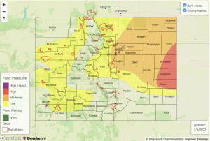
— A HIGH flood threat has been issued for portions of the Northeast & Southeast Plains
— A MODERATE flood threat has been issued for the Palmer Ridge and portions of the Urban Corridor and Front Range
— A LOW flood threat has been issued for portions of the Central Mountains, Northern Mountains, San Juan Mountains, Northwest Slope, Grand Valley and Southwest Slope
— Fire-Burn Forecast Summary: 2 burn areas under HIGH threat, 3 burn areas under a MODERATE threat, 4 burn areas under a LOW threat; click HERE for more info
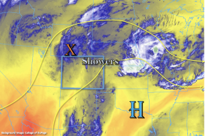
This morning there are some ongoing showers and weak storms over the northern Front Range and Northeast Plains with plenty of monsoon moisture and some mid-level energy overhead. PW at Denver was measured at a walloping 1.14 inches, which is right around the maximum moving average for this time of year! This value increases over towards the eastern border to about 1.4-1.5 inches. Even over Grand Junction, PW was measured at 1 inch, which is just above the 90th percentile. Both atmospheric profiles show plenty of surface moisture and a decent warm layer depth, which means storms should be very efficient at producing rainfall today. Another factor contributing to higher rainfall rates today will be slower steering flows under the ridging pattern. Storm movement should be clockwise across the state, so there will likely be a bit more of a northerly component to the steering flow over the far eastern plains due to the location of the High.
With a well-defined shortwave (orange “X”) also moving across the northern tier of the state, numerous storms are forecast to develop over this area by mid-afternoon. By later this afternoon and evening, the shortwave and ongoing storms should arrive to the adjacent eastern plains where there will be plenty of moisture (dew points were measured in the 60°Fs this morning), high instability and decent shear, so some severe storms are likely to develop along with upscale growth of the thunderstorms. A HIGH/MODERATE flood threat has been issued for today. Over the western and southern high terrains, storms should be more scattered in nature, but could still produce some small hail and strong outflow winds under the strong thunderstorms that develop along with local, heavy rainfall. A LOW flood threat has been issued. The heavy rainfall threat ends for most by this evening, but some thunderstorm activity may persist until about midnight over the eastern plains.
Today’s Flood Threat Map
For more information on today’s flood threat, see the map below. If there is a threat, hover over the threat areas for more details, and click on burn areas to learn more about them. For Zone-Specific forecasts, scroll below the threat map.
Zone-Specific Forecasts:
Urban Corridor, Front Range, Central Mountains, Northeast Plains, Southeast Plains & Palmer Ridge:
Scattered to numerous storms are forecast today with some severe storms possible over the adjacent eastern plains this afternoon and evening. In addition to the heavy rainfall threat, severe storms may produce large hail and damaging outflow winds. With slower storm motion, especially east, storms may linger for a couple hours. Isolated max 1-hour rain rates up to 1.4 inches (west) and 1.6 inches (adjacent plains) will be possible. This could cause isolated mud flows and debris slides over the steeper terrains as well as increased runoff, heavy ponding and road flooding over more impervious areas. A LOW/MODERTE flood threat has been issued through this evening. Over the far eastern plains, isolated storm totals between 3.5 and 4 inches will be possible under the stronger storm cores. This could cause rises in local creeks, road flooding and heavy field ponding. A HIGH flood threat has been issued with most storms winding down later this evening. A thunderstorm or two may linger into tonight.
Primetime: 1PM to 1AM
Northern Mountains, Northwest Slope, Grand Valley, Southwest Slope & San Juan Mountains:
Scattered storms are forecast today with isolate max 1-hour rain rates up to 1.3 inches possible. The majority of the rainfall will likely fall in the first 30-minutes under the stronger thunderstorms that develop. This could cause isolated mud flows and debris slides over the steeper terrains as well as road flooding. Stronger thunderstorms may produce some brief outflow winds and small hail. A LOW flood threat has been issued.
Primetime: 12:30PM to 9:30PM
Southeast Mountains, Raton Ridge & San Luis Valley:
More isolated storms are forecast this afternoon for these areas south. Max 1-hour rain rates may reach up to 0.3 inches over the high terrains, but most storms are forecast to produce totals under 0.2 inches and brief windy conditions. The southern San Luis Valley may see a little rainfall, but more wind and cloud cover is forecast for the area. Flooding is NOT expected today.
Primetime: 2PM to 8PM

