Issue Date: Tuesday, July 5th, 2022
Issue Time: 9:40AM MDT
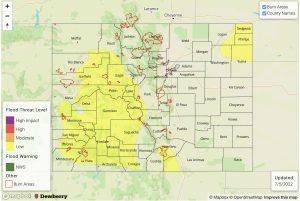
— A LOW flood threat has been issued for portions of the Central Mountains, San Juan Mountains, Southwest Slope, Southeast Mountains and Northeast Plains
— Fire-Burn Forecast Summary: 6 burn areas under MODERATE threat, 1 burn area under LOW threat; click HERE for more info
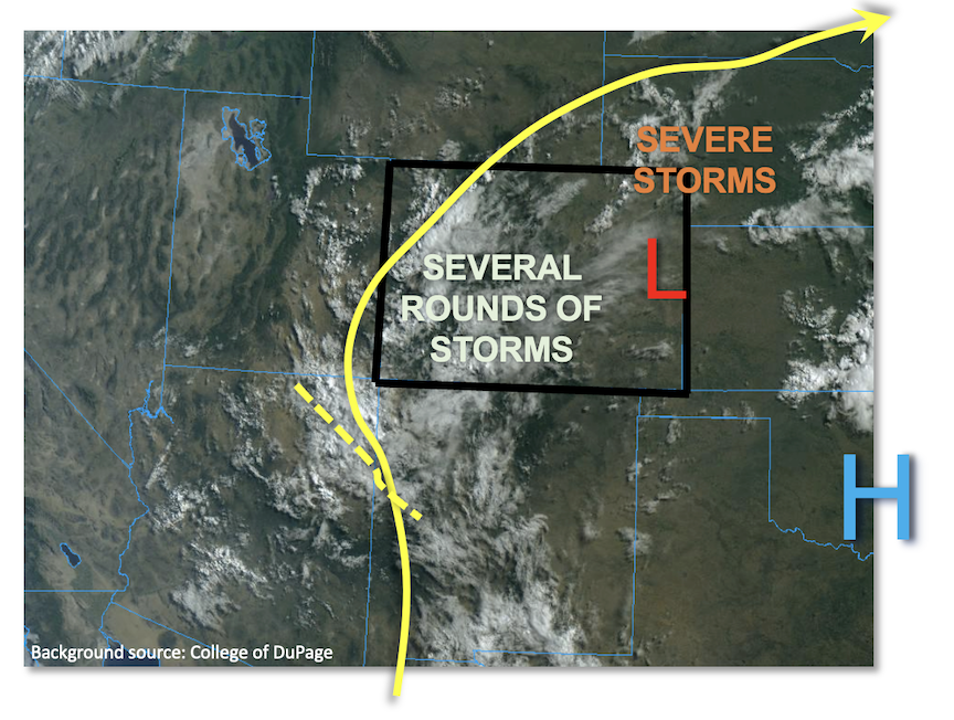
After a short lull, monsoon moisture has quickly re-entered Colorado from the south as shown in the visible satellite image below. Morning PW measured 0.99 inches at Grand Junction (up from 0.91 inches yesterday morning) and 0.76 inches at Denver (from 0.69 inches yesterday). Moreover, looking at the flow streamlines shows more moist air moving into western Colorado from AZ/NM where PW as high as 1.65 inches was noted at Tucson. Cloud cover along with scattered showers and even weak storms were already noted as of this morning, arising from elevated instability in association with a weak mid-level disturbance. This, along with normal elevated heating will drive numerous/widespread showers and storms over most of our high terrain today, with the highest coverage over central and southern regions. The big question mark regarding heavy rainfall potential will be instability. Cloud cover will undoubtedly reduce instability overall, but breaks in the clouds along with a gradual increase in moisture suggests localized instability up to 1,000 J/kg CAPE will be possible today. This, along with slow storm motion will support isolated heavy rainfall over mainly the 30-60 minute duration, warranting a LOW flood threat for most of the central/southern high terrain.
Further northeast, a mesoscale low pressure was noted over eastern Colorado today, which is expected to direct some moisture advection into the Northeast Plains. Widely scattered storms are expected this afternoon. With moderate instability expected, there will be a threat of large hail and damaging winds. With very slow storm motion, the threat of heavy rainfall will also exist. A LOW flood threat has been posted along the CO/KS/NE tri-border region.
Today’s Flood Threat Map
For more information on today’s flood threat, see the map below. If there is a threat, hover over the threat areas for more details, and click on burn areas to learn more about them. For Zone-Specific forecasts, scroll below the threat map.
Zone-Specific Forecasts:
Northern Mountains, Central Mountains, Grand Valley, San Juan Mountains, Southwest Slope, San Luis Valley, Southeast Mountains & Northwest Slope:
Partly to mostly cloudy with numerous/widespread showers and thunderstorms expected this afternoon and evening. Highest coverage will be over the central and southern high terrain, and adjoining foothills. Max 30-minute rainfall up to 0.8 inches, with max 1-hour rainfall up to 1.2 inches warrants a LOW flood threat for most of the higher terrain for isolated flash flooding, debris slides and mud flows. Widespread rainfall exceeding 0.5 inches is expected by Wednesday morning.
Primetime: 11AM through 10PM
Northeast Plains, Front Range, Urban Corridor, Palmer Ridge, Southeast Plains & Raton Ridge:
Mostly sunny to partly cloudy early then isolated to widely scattered showers and storms developing this afternoon. Highest coverage will be over the Northeast Plains, where severe weather in the form of large hail and damaging winds is also possible. Max 30-minute rainfall up to 1.8 inches and max 1-hour rainfall up to 2.5 inches warrants a LOW flood threat for parts of the Northeast Plains. Elsewhere, the shorter duration of the moderate/heavy rainfall should limit the flood threat.
Primetime: 1PM through 1AM

