Issue Date: Thursday, July 7th, 2022
Issue Time: 10AM MDT
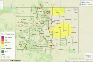
— A LOW flood threat has been issued for the Palmer Ridge and portions of the Northeast Plains, Urban Corridor, Front Range and Southeast Plains
— Fire-Burn Forecast Summary: 3 burn areas under LOW threat; click HERE for more info
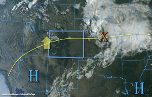
Colorado will be under a transitioning synoptic pattern over the next 24-hours as a strong ridge begins to build overhead, which will bring some very hot temperatures back to the state this weekend. There has been a downtick in the available moisture due to the location of the High, which is helping to produce the clear skies seen in the visible satellite imagery below. There is some mid-level energy that’s combining with the residual moisture to produce some cloud cover and light rainfall over northwestern Colorado. However, the main moisture axis is marked by a green dashed line below, which is both south and east of the state.
Despite the overall decrease in moisture from yesterday, PW this morning at Denver and Grand Junction was still quite elevated at 0.9 and 0.85 inches, respectively. So, there is plenty of residual moisture for storms today, but with the building ridge promoting subsidence, storms should be more widely scattered to scattered in nature. Expecting the storms that develop to favor the high terrains with some spill over into the adjacent eastern plains as the weak mid-level energy over northwestern Colorado transitions eastward. As far as the flood threat, a drier surface layer over western Colorado and the mountains means that storms in these areas today should pose more of a wind than heavy rainfall threat with only moderate rainfall rates forecast under the stronger storm cores that develop. Over the adjacent eastern plains, surface moisture will be less likely to mix out, and with steering flows still on the lower end and extra convergence near the elevated ridges, isolated heavy rainfall will be possible. A LOW flood threat has been issued for this reason.
Today’s Flood Threat Map
For more information on today’s flood threat, see the map below. If there is a threat, hover over the threat areas for more details, and click on burn areas to learn more about them. For Zone-Specific forecasts, scroll below the threat map.
Zone-Specific Forecasts:
Urban Corridor, Front Range, Northeast Plains, Southeast Plains & Palmer Ridge:
Widely scattered storms are forecast to develop over the Front Range by early afternoon and then spill into the adjacent plains later this afternoon and evening. As they reach into the deeper moisture and instability out east, storms should become more scattered. Max 1-hour rain rates up to 0.75 inches west and 2 inches east will be possible. A LOW flood threat has been issued for areas near the elevated ridges. In addition to local, heavy rainfall, stronger thunderstorms may produce strong outflow winds and small hail with a couple severe thunderstorms possible further east. Thunder and rainfall may linger over the plains overnight, but the flood threat should end a couple of hours after the sun sets.
Primetime: 12PM to 6AM
Northern Mountains, Central Mountains, Southeast Mountains, Raton Ridge, San Luis Valley Northwest Slope, Grand Valley, Southwest Slope & San Juan Mountains:
Isolated to widely scattered storms are forecast today favoring the central and northern high terrains for accumulation. With less surface moisture than yesterday, stronger storms that develop will be capable of producing strong, but brief outflow winds. Isolated max 1-hour rain rates up to 0.75 inches over the north/central high terrains and Raton Ridge will be possible. Further south, rain rates up to 0.5 inches are forecast. Flooding is NOT expected today.
Primetime: 12PM to 8:30PM (west); 2PM to 11PM (east)

