FTB 07-06-2017: Summer Heat Wave

Issue Date: Thursday, July 6, 2017
Issue Time: 10:15AM MDT

–Flooding is NOT expected today

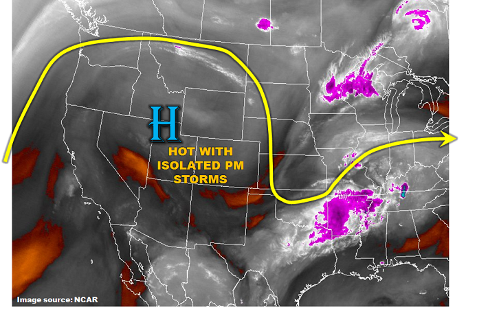
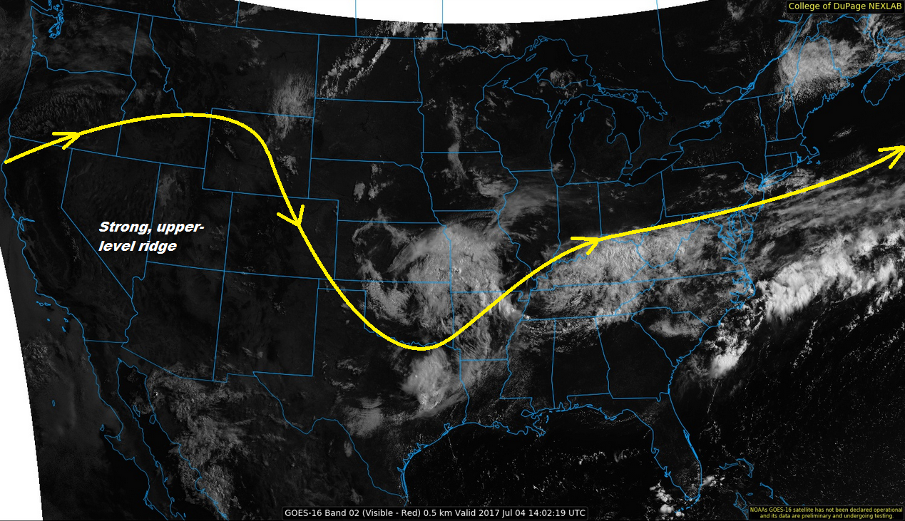
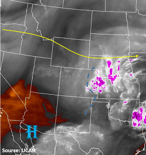
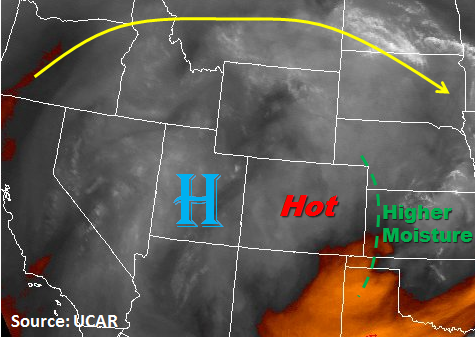
The upper level ridging pattern continues its hold over the western US again today leading to high surface temperatures. Temperatures at lower elevations could reach 100F with the higher terrain reaching 80-85F. As with the last couple of days, some moisture remains under the ridge. This will lead to some isolated thunderstorms over the high country again this afternoon. Over the Northeast Plains, there will be a minor disturbance this afternoon that will enhance upward motion. This could lead to scattered thunderstorms later this afternoon and evening. Since the moisture remains low, the main threat for all storms that form will be gusty winds, small hail and dry lightning. The storm motion will be slow today (5-10 knots), so there is a possibility for local minor street flooding or field ponding under storm cores. Flooding is not expected today.

Today’s Flood Threat Map

For more information on today’s flood threat, see the map below (hover over threat areas for more details). For Zone-Specific forecasts, scroll below the map.


Zone-Specific Forecasts:

Grand Valley, Northwest Slope, Northern Mountains, Central Mountains, Southwest Slope, San Luis Valley, San Juan Mountains, Front Range:

Sunny early becoming partly cloudy in the afternoon. Temperatures are expected to be 5-10F above climatology. Lower elevations may reach 100F. Isolated thunderstorms and showers are expected over the higher terrain with max 1-hour rainfall of 0.7 inches. Flooding is not expected today.

Primetime: 1PM to 9PM

Palmer Ridge, Southeast Mountains, Raton Ridge, Urban Corridor, Northeast Plains, Southeast Plains:

Sunny early becoming partly cloudy in the afternoon. Temperatures will climb near 100F today for the lower elevations. An isolated shower or weak storm will be possible over higher terrain and close to the mountains as well as the Northeast Plains. Max 1-hour rainfall up to 0.9 inches under storm cores. Flooding is not expected today.

Primetime: 2PM to 11PM

FTB 07-05-2017: Heat Continues, With A Few Isolated PM Storms

Issue Date: Wednesday, July 5th, 2017
Issue Time: 9:50AM MDT

— Flooding is NOT expected today

A strong upper-level ridge continue to intensify over the western US today (see water vapor image, below). This means very hot weather will continue across most of Colorado, with temperature of 5-15 F above normal. The good news is that with the ridge position being so far north, some moisture will be able to make it into southern Colorado from the east. Thus, isolated to widely scattered afternoon thunderstorms are expected over the higher terrain of mainly southwest Colorado. The bad news is that very limited rainfall is expected and the storms will actually pose a bigger threat through dry lightning potential than any rainfall. Flooding is not expected today.

Today’s Flood Threat Map

For more information on today’s flood threat, see the map below (hover over threat areas for more details). For Zone-Specific forecasts, scroll below the map.

Zone-Specific Forecasts:

Grand Valley, Northwest Slope, Northern Mountains, Central Mountains, Southwest Slope, San Luis Valley, San Juan Mountains, Front Range:

Sunny early, then partly cloudy and continued very warm today with high temperatures 5 – 10F above normal. Isolated to widely scattered thunderstorms and showers are expected mainly in the highest terrain and also southwest Colorado. Max 30-minute rainfall up to 0.3 inches. Dry lightning will increase the chances of wildfire occurrence. Flooding is not expected today.

Primetime: 1PM to 8PM

Palmer Ridge, Southeast Mountains, Raton Ridge, Urban Corridor, Northeast Plains, Southeast Plains:

Sunny early then partly cloudy and continued hot today with high temperatures 10-15F above normal. An isolated shower or weak storm cannot be ruled out closer to the mountains as well as the southeast part of the state. Max 30-minute rainfall up to 0.3 inches (west) and 0.6 inches (east) Flooding is not expected today.

Primetime: 2PM to 9PM

FTB 07-04-2017: Upper-Level Ridge Building Out West

Issue Date: 7/4/2017
Issue Time: 9:00 AM

NO FLOOD THREAT IS FORECAST.

Mother Nature is doing her best to give Colorado nice weather for Independence Day, and generally speaking, she is coming through. A strong, upper-level ridge is building in from the west today, and will result in increasing subsidence and decreasing showers/storms as compared to the past few days. There is still enough shallow moisture in place for isolated showers/thunderstorms this afternoon and evening, but for most regions they will produce more gusty winds and lightning than rain.

The exception to this will be over the far eastern plains, where a bit more surface moisture and instability exists, giving the atmosphere an opportunity to produce brief periods of moderate rainfall, hail up to 1 inch in diameter, and strong winds up to 60 mph. Rain rates will still not meet flash flood thresholds, so no flood threat is warranted. For more information regarding timing and rain rates, please see the zone-specific forecast discussions below.

Today’s Flood Threat Map

For more information on today’s flood threat, see the map below (hover over threat areas for more details). For Zone-Specific forecasts, jump below the map.

Flood Threat Legend

Zone-Specific Forecasts

Palmer Ridge, Northeast Plains, and Southeast Plains:

Mostly sunny skies and hot temperatures will be the main weather story today, with isolated thunderstorms expected to break up the otherwise quiet weather during the afternoon and evening hours. Maximum rain rates are as follows:

Western half of Palmer Ridge: 0.2-0.4 inches/hour
Eastern half of Palmer Ridge: 0.4-0.8 inches/hour
Northeast Plains and Southeast Plains: 1.0-1.5 inches/hour

Timing: Noon – 10 PM

Northern Mountains, Northwest Slope, Front Range, Urban Corridor, Southeast Mountains, Central Mountains, Grand Valley, Southwest Slope, Raton Ridge, San Juan Mountains, and San Luis Valley:

Mostly sunny skies and warm/hot temperatures are expected, only to be broken up by isolated showers/weak thunderstorms. The best coverage of storms, relatively speaking, will occur over the Front Range, Southeast Mountains, and the Urban Corridor, with lesser activity expected elsewhere. With dry sub-cloud air in place, evaporation of falling precipitation will be efficient, showers/storms will result in mainly gusty winds and light rainfall. Dangerous cloud-to-ground lightning is expected from thunderstorms, so please whenever you hear thunder roar, go indoors. Maximum rain rates are as follows:

Northern Mountains, Central Mountains, Front Range, Southeast Mountains, Urban Corridor, San Luis Valley, and San Juan Mountains: 0.4-0.8 inches/hour
Raton Ridge: 0.5-0.9 inches/hour
Southwest Slope, Grand Valley, and Northwest Slope: 0.1-0.3 inches/hour

Timing: Noon – 10 PM

FTB 07-03-2017: Isolated Severe Storms on the Eastern Plains, But Limited Rainfall

Issue Date: Monday, July 3, 2017
Issue Time: 10:30 AM MDT

— Flooding is NOT expected today

A mid-level trough crossed into the state late last night that is causing the upper level cloudiness this morning. As heating throughout the morning continues, these clouds will begin to burn off. The water vapor image below shows quite a bit of moisture this morning east of the Continental Divide. Dew points on the eastern plains range from 50F to 60F. Throughout the day, this low-level moisture will be mixed out and the higher moisture will be confined to the Northeast Plains and Southeast Plains along the Kansas border. A shortwave trough will slide into the state this afternoon creating a lifting mechanism to trigger showers and thunderstorms. The best chance for severe weather will be along the CO/KS border. Although the moisture here will be the highest in the state, dew points will be under 55F. Therefore, any severe thunderstorms that do form will be high-based and have limited rainfall. These storms will also be moving south/southeast at 15-20 kts limiting their flood potential. Under the cores, locally, there is a possibility for minor street flooding and field ponding due to brief, heavy rain.

Out west, the fire danger continues today due to the lack of rainfall in June. This will be further exacerbated by dry lightning that could accompany any weak storms that manage to form over the higher terrain.


Today’s Flood Threat Map

For more information on today’s flood threat, see the map below (hover over threat areas for more details). For Zone-Specific forecasts, scroll the map below.

Flood Threat Legend

Zone-Specific Forecasts:

Palmer Ridge, Northeast Plains, Southeast Plains:

Scattered showers and thunderstorms are likely after 2pm, lasting until about midnight. Max 1-hour rainfall up to 1.4 inches under the storm cores will be just under flood threat intensity; thus no threat is issued. There may be minor street flooding and field ponding. Severe weather will be likely, including hail up to 1.25 inches in diameter and gusty winds up to 65 mph.

Primetime: 2PM to 12AM (near Kansas border)

Southeast Plains, Raton Ridge, Urban Corridor, Front Range:

Sunny early then scattered showers and thunderstorms will develop over the higher terrain around noon. Rainfall rates in the mountains could be as high as 0.5 inches per hour. As they push off the mountains into the Urban Corridor early this afternoon, expect maximum rainfall rates up to 0.8 inches per hour. Gusty winds and possibly a dry microburst will accompany thunderstorms that form.

Primetime: 12PM to 9PM

Grand Valley, Northwest Slope, Northern Mountains, Central Mountains, Southwest Slope, San Luis Valley, San Juan Mountains:

Mostly sunny with average temperatures today. An isolated shower or weak thunderstorm cannot be ruled out over higher terrain. Max 1-hour rainfall up to 0.5 inches. Gusty winds and dry lightning will be the main threat.

Primetime: 12PM to 8PM