Issue Date: Monday, July 3, 2017
Issue Time: 10:30 AM MDT
— Flooding is NOT expected today
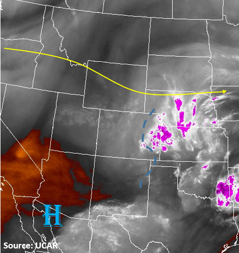
A mid-level trough crossed into the state late last night that is causing the upper level cloudiness this morning. As heating throughout the morning continues, these clouds will begin to burn off. The water vapor image below shows quite a bit of moisture this morning east of the Continental Divide. Dew points on the eastern plains range from 50F to 60F. Throughout the day, this low-level moisture will be mixed out and the higher moisture will be confined to the Northeast Plains and Southeast Plains along the Kansas border. A shortwave trough will slide into the state this afternoon creating a lifting mechanism to trigger showers and thunderstorms. The best chance for severe weather will be along the CO/KS border. Although the moisture here will be the highest in the state, dew points will be under 55F. Therefore, any severe thunderstorms that do form will be high-based and have limited rainfall. These storms will also be moving south/southeast at 15-20 kts limiting their flood potential. Under the cores, locally, there is a possibility for minor street flooding and field ponding due to brief, heavy rain.
Out west, the fire danger continues today due to the lack of rainfall in June. This will be further exacerbated by dry lightning that could accompany any weak storms that manage to form over the higher terrain.
Today’s Flood Threat Map
For more information on today’s flood threat, see the map below (hover over threat areas for more details). For Zone-Specific forecasts, scroll the map below.


Zone-Specific Forecasts:
Palmer Ridge, Northeast Plains, Southeast Plains:
Scattered showers and thunderstorms are likely after 2pm, lasting until about midnight. Max 1-hour rainfall up to 1.4 inches under the storm cores will be just under flood threat intensity; thus no threat is issued. There may be minor street flooding and field ponding. Severe weather will be likely, including hail up to 1.25 inches in diameter and gusty winds up to 65 mph.
Primetime: 2PM to 12AM (near Kansas border)
Southeast Plains, Raton Ridge, Urban Corridor, Front Range:
Sunny early then scattered showers and thunderstorms will develop over the higher terrain around noon. Rainfall rates in the mountains could be as high as 0.5 inches per hour. As they push off the mountains into the Urban Corridor early this afternoon, expect maximum rainfall rates up to 0.8 inches per hour. Gusty winds and possibly a dry microburst will accompany thunderstorms that form.
Primetime: 12PM to 9PM
Grand Valley, Northwest Slope, Northern Mountains, Central Mountains, Southwest Slope, San Luis Valley, San Juan Mountains:
Mostly sunny with average temperatures today. An isolated shower or weak thunderstorm cannot be ruled out over higher terrain. Max 1-hour rainfall up to 0.5 inches. Gusty winds and dry lightning will be the main threat.
Primetime: 12PM to 8PM