Issue Date: Wednesday, July 26, 2017
Issue Time: 10:50AM MDT
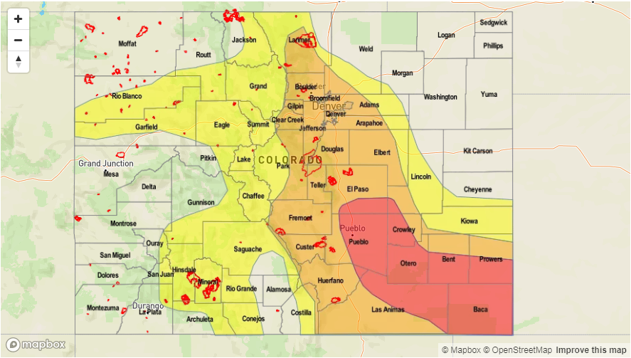
—HIGH flood threat for portions of the Southeast Plains. There will be an ongoing threat for the Southeast Plains overnight.
—MODERATE flood threat for portions of the Northeast Plains, Front Range, Urban Corridor, Palmer Ridge, Southeast Mountains, Raton Ridge, Southeast Plains
—LOW flood threat for nearly the entire state
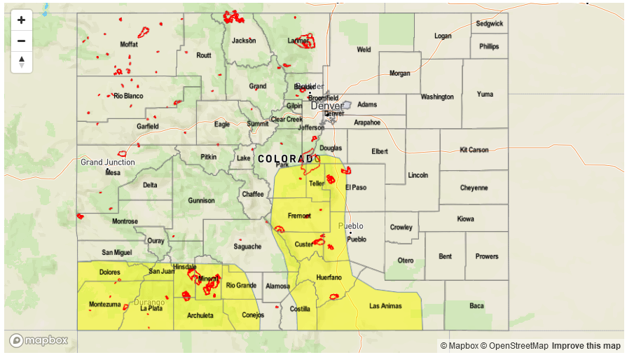
Afternoon Update (5pm): The efficiency of storms thus far has been very impressive. The High flood threat will remain, but the western portion of the high threat has been been dropped. Storms currently firing over the Palmer Divide are expected to move southeast later this evening, thus the high threat has been extended north. These heavy rainfall producing storms will last into the night, and showers may linger into the early morning hours. More drying has occurred over the Western portion of the state, so the Low threat has been pulled back to areas that have the better moisture and lift.
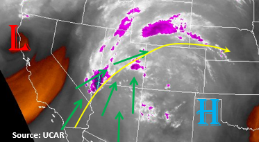
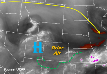
Moisture is abundant this morning across the entire state with both Denver and Grand Junction soundings showing very juicy low and mid-levels. Precipitable Water (PW) at Denver was 1.21 inches and Grand Junction was measured at 1.41 inches. Dew points readings on the plains are as high as 64F in the northeast corner of the state with at least 60F over most of the eastern plains. A stationary front was draped across the Northeast Plains early this morning, which is responsible for the stratus deck over the Northeast Plains and northern portion of the Urban Corridor. Monsoon flow remains in place today with southwest winds in the upper levels due to the High pressure centered over Oklahoma. Early this morning, there were also lingering light showers over the Central and Northern Mountains.
Today, the moisture will remain in tack in both the lower and mid-levels, but cloud cover may limit where instability can build. Along the Front Range, storms will favor the higher terrains for initiation around noon. As they move off the mountains in the late afternoon, storms should survive along the Urban Corridor. Cloud cover may limit how far east these storms are able to survive, but some isolated storms could survive further east along the southern portion of the Front Range within the higher-elevated Palmer Ridge. Rain rates up to 1.75 inches per hour are possible with 3-hour totals up to 2.6 inches.
The Southeast Plains are able to build a decent amount of instability this afternoon. There also appears to be some weak shear, so this environment should be primed for heavy rainfall and possibly a few severe storms. After storms begin moving off the higher terrain, models show a Mesoscale Convective System (MCS) forming that will persist well into the night and early morning hours. Storm motion will be the east/southeast at 15 knots, so very widespread, heavy rainfall is likely. Localized 3-6 hour totals exceeding 4.5 inches are likely. Threats include small hail, gusty winds, field ponding and small stream and road flooding. Over the Southeast Mountains, burn scars should be monitored closely today with the high moisture and widespread, heavy rainfall. Threats over the steeper terrain include small stream and road flooding, debris slides and mud flows.
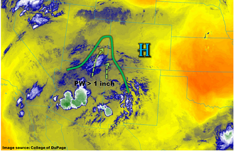
Over the western portion of the state, moisture mixes out a bit compared to the last couple of days. However, PW still remains high enough that localized, heavy rainfall will occur over the higher terrain with upslope flow beginning midday. The more easterly movement of the storms should keep storms confined to the higher terrain. Over already saturated soils, there is still a threat for debris slides, mud flows and road flooding. Small streams have already been reported as running high, so these need to be monitored closely for road flooding. 1-hour rain rates will be just under 1 inch, but localized 24-hour totals could be as high as 2.1 inches.
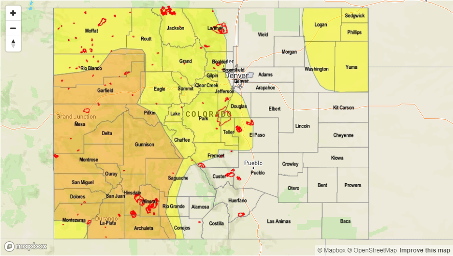
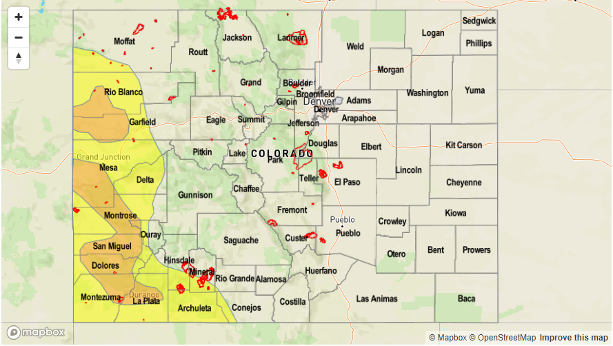
Today’s Flood Threat Map
For more information on today’s flood threat, see the map below (hover over threat areas for more details). For Zone-Specific forecasts, scroll below the map.

Zone-Specific Forecasts:
Northwest Slope, Grand Valley, Southwest Slope, San Juan Mountains, Central Mountains, Northern Mountains, San Luis Valley:
Cloudy this morning over the northwest with skies partially clearing before upslope flow begins around 11AM. Max 1-hour rain rates just under 1 inch are possible with local 24-hour totals up to 2.1 inches. Debris slide, mud flows and road flooding are the main threats. A Low threat has been issued for the higher terrain portions of the region. Storm activity should start to subside after sundown, but some storms may linger until midnight.
Primetime: 11AM to 12AM
Front Range, Urban Corridor, Northeast Plains, Southeast Mountains, Southeast Plains, Raton Ridge, Palmer Ridge:
Partly cloudy over the Northeast Plains and northern Urban Corridor. Clouds will begin to break up along the Urban Corridor, but not as much over the Northeast Plains, which will limit instability. Max 1-hour rain rates up to 1.75 inches will be possible which could cause urban and small stream flooding. Burn scars will need to be monitored closely for mud flows, debris slides and flash flooding. Over the adjacent plains, localized 3-6 hour totals will likely exceed 4.5 inches. There is a High/Moderate flood threat for the storms over the Southeast Plains that continues overnight.
Primetime: 12PM to 4AM