Issue Date: Sunday, July 23, 2017
Issue Time: 09:40AM MDT
—LOW flood threat for portions of the Front Range, Urban Corridor, Central Mountains, San Juan Mountains, Southwest Slope, Southeast Mountains, Southeast Plains, Raton Ridge
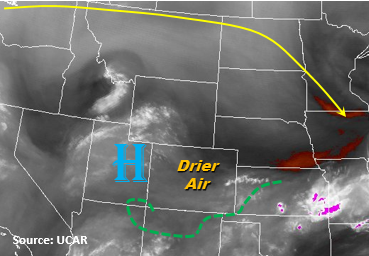
With the upper-level ridge off to the northwest of Colorado and the High pressure over Utah, drier air has moved into the state which can be seen in the water vapor imagery below. Throughout the day, the ridge will move slightly to the east, but the large-scale wind pattern will not allow ample monsoon moisture to return to Colorado. Precipitable Water (PW) this morning at Denver was 0.81 inches and 0.62 inches in Grand Junction with large amounts of drying in the upper-levels. This should limit the widespread potential for heavy rainfall as compared with the last few days.
Daytime heating will help build some instability over the mountains just as upslope flow begins around noon. There should still be enough moisture in the atmosphere for thunderstorms to fire over the southern mountains, but they will be more isolated in nature when compared to the last few days. Most storms will be confined to the high country and quickly evaporate as they move off the mountains, but one or two storms over the immediate and adjacent plains cannot be ruled out further south. Local, heavy rain is still possible for the stronger isolated thunderstorms. The main threats today will be debris slides over saturated soils, small stream and road flooding, gusty winds and small hail with the more severe storms.
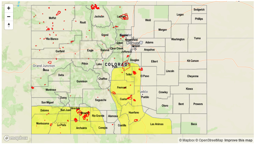
Today’s Flood Threat Map
For more information on today’s flood threat, see the map below (hover over threat areas for more details). For Zone-Specific forecasts, scroll below the map.

Zone-Specific Forecasts:
Southwest Slope, San Juan Mountains, San Luis Valley, Southeast Mountains, Urban Corridor, Raton Ridge, Southeast Plains:
Sunny this morning with storms beginning to form over the higher terrain around noon. Storms should be mostly confined to the higher terrain with an isolated storm over the adjacent plains possible. Overall, the rainfall will be more isolated in nature with 1-hour rain rates up to 1.3 inches in the mountains and 1.6 inches over the adjacent plains. 3-hr totals up to 2 inches are possible. Storms will start to dissipate after sundown and quickly come to an end. There is a Low flood threat for today.
Primetime: 12PM to 10PM
Northwest Slope, Northern Mountains, Central Mountains, Grand Valley, Northeast Plains, Front Range, Palmer Ridge:
Sunny today with temperatures slightly cooler than yesterday. Rain rates over the higher terrain will be as high as 0.8 inches per hour with 3-hr totals near 1.3 inches. Gusty winds will likely accompany the bigger storms that form. There is no flood threat.
Primetime: 12PM to 10PM