Issue Date: Monday, July 24, 2017
Issue Time: 10:45AM MDT
— MODERATE/LOW flood threat for Northwest Slope, Grand Valley, Central Mountains, Southwest Slope, San Juan Mountains
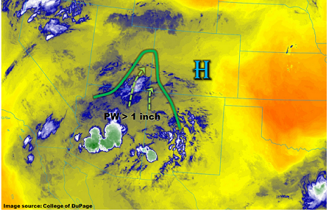
This morning’s GOES-16 low-level water vapor image, below, shows a classic monsoon flow pattern across the Four Corners region. A weak upper-level high is centered over central Colorado, with drier air to its east and moist air on its west side. Ongoing showers and storm activity can be easily seen in Arizona and New Mexico. Despite some suggestion even a few days ago that drier air will impinge on western Colorado, this has not occurred. In fact, this morning, surface dew point temperatures are approaching near 60F on the southwest side of the San Juans – a very high reading for this region. Precipitable water (PW) values are over 1 inch along the southwest CO border with NM and UT. PW is expected to gradually increase through the day as clockwise flow around the ridge, combined with outflow boundaries will increase boundary layer moisture. Weak steering winds this morning will turn northeast at 10-15 mph, which is slow enough to allow for heavy rainfall to accumulate at any given locale. A Moderate flood threat has been posted for climatologically favored foothills in the San Juans Mountains as well as the Uncompahgre and Roan plateaus. Mud flows and debris slides will be the primary risk today, though isolated flash flooding will also be possible.
Farther east, lower boundary layer moisture today suggests lower rainfall intensities compared to the past few days. Although the Palmer Ridge has witnessed rainfall rates on the high side of ensemble guidance over the last 48-72 hours, today’s guidance shows a large enough drop compared to yesterday that even “worst-case scenario” type intensities should remain below flood threat levels.
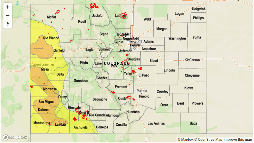
Today’s Flood Threat Map
For more information on today’s flood threat, see the map below (hover over threat areas for more details). For Zone-Specific forecasts, scroll below the map.

Zone-Specific Forecasts:
Northwest Slope, Grand Valley, Southwest Slope, Northern Mountains, Central Mountains, San Juan Mountains, San Luis Valley:
Partly cloudy early then scattered to numerous showers and thunderstorms developing by late morning. Max 1-hour rain rates up to 1.3 inches, with max 24-hour rates up to 2.3 inches. Mud flows and debris slides will be the primary threat, though isolated flash flooding will also be possible. A Moderate flood threat has been issued for western parts of the region, with a Low threat surrounding that. Storm activity will be possible through the late evening hours, as a steady supply of monsoon moisture gets advected northward.
Primetime: 11:30AM to 1AM
Front Range, Urban Corridor, Palmer Ridge, Northeast Plains, Southeast Mountains, Raton Ridge, Southeast Plains:
Sunny early then becoming partly cloudy with isolated showers and a weak thunderstorm possible this afternoon. Max 1-hour rainfall up to 1 inch will be possible. Gusty winds could accompany the strongest cells. Flooding is not expected today.
Primetime: 1PM to 8PM