Issue Date: Tuesday, July 25, 2017
Issue Time: 10:20AM MDT
—LOW/MODERATE flood threat for portions of the Northwest Slope, Northern Mountains, Grand Valley, Central Mountains, Southwest Slope, San Juan Mountains, Front Range, Urban Corridor, Northeast Plains
The surge of monsoon moisture yesterday brought nearly continuous thunderstorms and showers to the western portion of the state yesterday. After sundown, showers continued over the Southwest Slope and moved northward throughout the morning hours. Light precipitation is still occurring under some of the deeper plumes. Cloud cover from this complex of storms can be seen in the visible satellite image below. This satellite image reflects how much moisture has returned with this surge and will play a role in the heavy rainfall 24-hour totals today. Precipitable Water (PW) was measured at 1.31 inches in Grand Junction this morning, which is near record levels! In Denver, PW was at 0.69 inches but is forecasted to rise throughout the day to over 1 inch.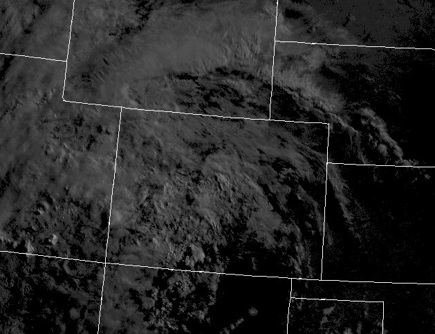
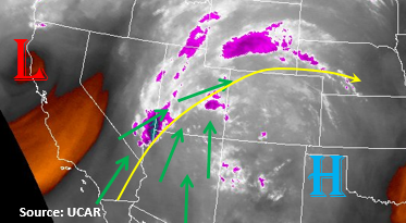
A High pressure center is currently positioned over the Texas Panhandle, with a trough off the coast of northern California. These features, along with the weak upper-level ridge to our southeast, is helping transport the monsoon moisture northward. PW is forecasted to rise over 1 inch nearly statewide by early this afternoon, with the western slope still slightly increasing. This moisture has and will continue to reach the higher terrain west of the Continental Divide. With steering flow aloft being 10-15 knots, heavy and widespread rainfall is expected. Current storms will continue to move north/northwest with the vorticity maximum and the next set of storms will begin to fire over the higher terrain just after noon. Although 1-hour rain rates will won’t likely be higher than 1-inch per hour, 3-hr totals up to 1.8 inches are possible and 24-hour totals up to 2 inches. This additional precipitation will be enough to trigger mud flows, land slides, small stream and road flooding especially over burn scars and locations that have accumulated a lot of rainfall the last few days.
Further east, cloud cover should begin to burn off in the late morning hours. Where the sun is able to shine through, more instability will be able to build during the early afternoon. The more easterly movement of the storms will allow them to drift into the adjacent plains in the late afternoon. Higher terrain areas along the Palmer Divide in the southern Urban Corridor will be favored for the heavier rain-producing thunderstorms initially. Rain rates up to 1.1 inches per hour are conceivable with 3-hr rates up to 1.8 inches. Over the Northeast Plains, there is a possibility for some severe storms as long as cloud cover doesn’t become an issue and outflow boundaries help trigger surface convergence. With higher PW, thunderstorms could produce heavy rainfall. Rain rates up to 1.75 inches per hour are possible with 3-hr rates up to 2 inches. Gusty winds, 1-inch hail, field ponding and road flooding are possible with the more severe thunderstorms.
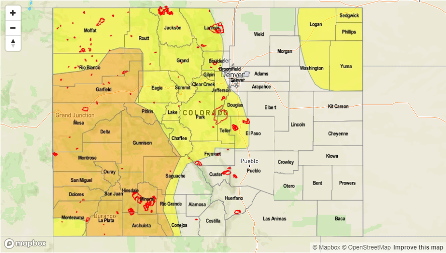
Today’s Flood Threat Map
For more information on today’s flood threat, see the map below (hover over threat areas for more details). For Zone-Specific forecasts, scroll below the map.

Zone-Specific Forecasts:
Northwest Slope, Grand Valley, Southwest Slope, Northern Mountains, Central Mountains, San Juan Mountains, San Luis Valley:
Cloudy this morning with some lingering showers moving to the north. Max 1-hour rain rates up to 1 inch are possible with 24-hour totals up to 2.3 inches. Debris slide, mud flows and isolated flash flooding will be possible. A Moderate threat has been issued for western portions of the region with a Low covering all areas that have had lots of rain the last few days. Storm activity should start to subside after sundown, but some storms may linger until midnight.
Primetime: 11AM to 12AM
Front Range, Urban Corridor, Northeast Plains, Southeast Mountains, Southeast Plains, Raton Ridge, Palmer Ridge:
Partly cloudy becoming sunny with cooler temperatures where cloud cover persists. Over the high terrain, more isolated showers over the Southeast Mountains and more widespread up north. Max 1-hour rain rates up to 0.8 inches will be possible. Over the adjacent plains, max 1-hr rain rates up 1.1 inches possible with 3-hr totals near 1.8 inches. Gusty winds and small hail will likely accompany the bigger storms that form. There is a Low flood threat.
Primetime: 12PM to 12AM