Issue Date: Monday, August 7, 2017
Issue Time: 10:55AM MDT
— HIGH riverine flood threat Fountain Creek and Arkansas River to Lamar
— LOW/MODERATE flood threat Northwest Slope, Northern Mountains, Grand Valley, Urban Corridor, Central Mountains, Front Range, Palmer Ridge, Southeast Plains, Southeast Mountains
Afternoon update likely
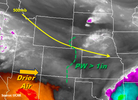
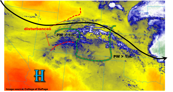
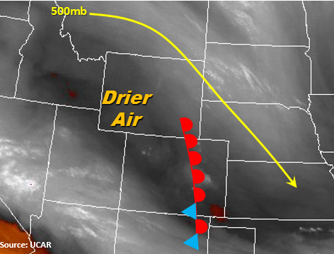
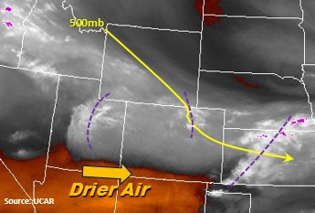
A moist low-level atmosphere and cooler temperatures are present throughout the state this morning. Cloud cover or fog are present over nearly the entire state with the exception of the SW corner where drier air can be seen on the water vapor imagery below. The overnight mesoscale convective system (MCS) is exiting the eastern plains over the KS/OK border this morning. Moisture rich air is beginning to regenerate showers over the Northeast Plains this morning with convective temperatures around 65F today. With moisture intact throughout the day and multiple shortwaves moving through the state, expect cloud cover and rain to continue throughout the morning and afternoon over the NE portion of the state. Once again, the 500mb ridge will continue to provide NW/W flow over the state and multiple mid-level waves for lift to generate storms throughout the day. We will continue to monitor the strength and efficiency of the waves throughout the day and likely provide a PM update.
Further south, east of the Continental Divide, storms will begin to fire over the higher terrain later this morning from a shortwave within the NW/W flow. A second wave of storms will initiate over the higher terrain this afternoon, with a possible third wave this evening. As the storms move off the mountains, they will initially favor the higher terrain of the Palmer Ridge. Slow easterly/southeasterly flow with the multiple rounds of storms will lead to heavy rainfall over the mountains and immediate adjacent plains. Flood threats include small stream and road flooding, mud flows and debris slides especially over burn scars. Over the more urban areas, road flooding and field ponding are likely. The multiple rounds of storms in the high-moisture environment warrant a Moderate flood threat today. Eventually the storms will form a MCS, similar to yesterday, as they move over the far eastern plains later this evening. The strength of the MCS is forecasted to be relatively weak with lack of instability, but rainfall totals up to 4 inches could still be possible. Once again the flood threat for the eastern plains continues overnight.
West of the Continental Divide, the embedded shortwaves in the westerly flow will also help trigger widespread storms in the moisture rich atmosphere. Westerly steering flows should confine the heavier rain producing storms to the higher terrains. Along the southern border, the drier air seen the water vapor imagery should limit rainfall totals. A shower or two in the Grand Valley cannot be ruled out as convection from the west moves into the state. The Flat Tops and Roan Plateau are particularly susceptible today to mud flows, debris slides and road flooding with storm totals as high as 2 inches.
As mentioned in earlier posts, the Arkansas River is running extremely high from the July rainfall. Current flows from the headwaters downstream to the Kansas border are in the 75th to 90+ percentiles. Riverine flooding is likely with the saturated soils and multiple rounds of rainfall today. A High threat has been issued from Fountain Creek (vulnerable to flooding) south to Pueblo and along the Arkansas to Lamar for rapidly rising waters and flooding starting midday.
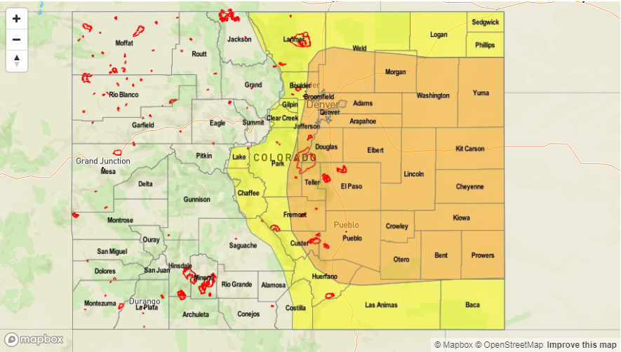
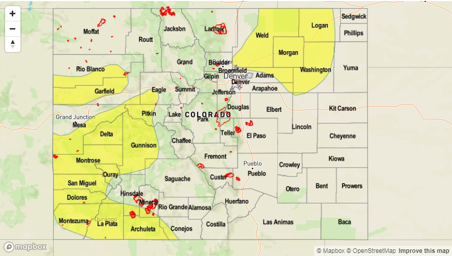
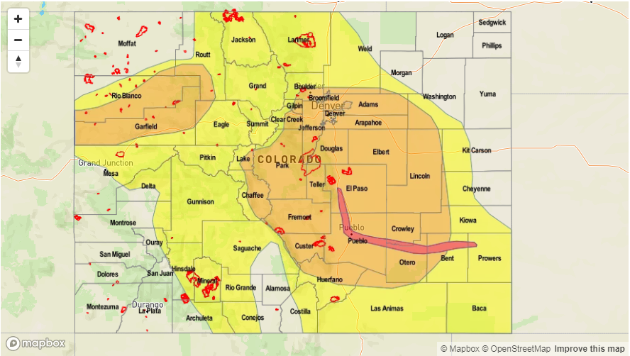
Today’s Flood Threat Map
For more information on today’s flood threat, see the map below (hover over threat areas for more details). For Zone-Specific forecasts, scroll below the map.

Zone-Specific Forecasts:
Front Range, Urban Corridor, Palmer Ridge, Northeast Plains, Southeast Mountains, Raton Ridge, Southeast Plains:
Low-level clouds and rain this morning with multiple rounds of precipitation expected. Storms will become more severe where sun is able to break through and create instability. Max 3-hour rainfall up to 2.2 inches (east), 1.5 inches (west). Localized max 24-hour rainfall over 4 inches possible (east) with 24-hour amounts up to 3 in (west). Riverine flooding along Fountain Creek and the Arkansas River to Lamar is likely with saturated soils and widespread rainfall. A Moderate and High flood threat has been issued today.
Primetime: 10:30AM to 3AM
Northwest Slope, Grand Valley, Southwest Slope, Northern Mountains, Central Mountains, San Juan Mountains, San Luis Valley:
High moisture and embedded shortwaves will create multiple rounds of rainfall today. 3-6 hour totals up to 2 inches over the Flat Tops and Roan Plateau put this area at particular risk for mud flows, debris slides and road flooding. 3-hr rain totals up to 2 inches possible (north) and 1.2 inches (south). There is a Moderate/Low flood threat for today.
Primetime: 11AM to 10PM