Issue Date: Saturday, August 5, 2017
Issue Time: 10:45AM MDT
— LOW flood threat for Northeast Plains, Urban Corridor, San Juans, Southwest Slope, Grand Valley, Northwest Slope
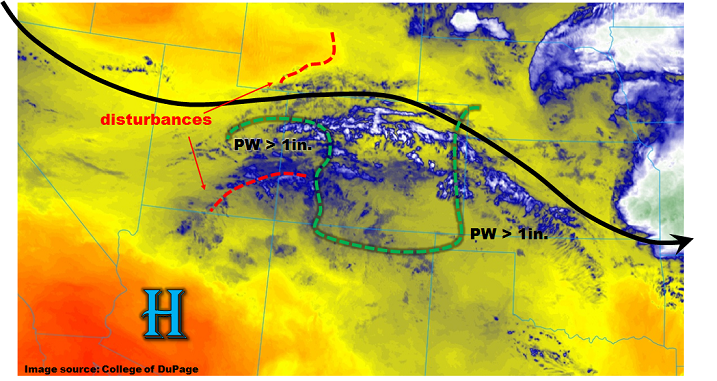
As mentioned in previous Flood Threat Bulletins and Outlooks, an active weather pattern has setup across Colorado. The central feature supporting this is the large-scale trough located across the US Great Plains. As shown in this morning’s water vapor image below, a weak jet stream lies just north of Colorado. Within it and in close proximity are numerous ripples, or shortwaves (or even mini-shortwaves) that are supporting mid to high level clouds this morning. In particular, the feature in southwest Colorado is likely a remnant of yesterday’s convection and will be a factor in supporting heavy rainfall as instability develops this afternoon over the western slope. Moisture is somewhat lower today across central Colorado with Precipitable Water (PW) as low as 0.6 inches. However, PW greater than 1 inch is found in far eastern Colorado as well as the western parts of the state. This morning’s Grand Junction sounding showed a PW of 1.03, which is above normal for this time of year. Steady to slightly increasing PW is expected in western Colorado due to moisture advection from the west.
At the surface, a high pressure cell was located over southwest Colorado, which will promote some enhanced low-level moisture advection into western facing foothills of the San Juans, Elk Mts. And Grand Mesa. Much like yesterday, we expect scattered to numerous showers and thunderstorms this afternoon. A Low flood threat has been posted, mainly for mud flows and debris slides. Farther east, downsloping flow will once again prevail closer to the mountains. However, a weak boundary is expected to develop along the South Platte River this afternoon. As storms form of the Cheyenne Ridge, they will move southeast and encounter higher instability and higher moisture. The strongest cells will have the potential to produce heavy short-term rainfall, and a Low flood threat has been posted for isolated flash flooding. Large hail will also be possible with these cells.
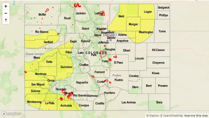
Today’s Flood Threat Map
For more information on today’s flood threat, see the map below (hover over threat areas for more details). For Zone-Specific forecasts, scroll below the map.

Zone-Specific Forecasts:
Front Range, Urban Corridor, Palmer Ridge, Northeast Plains, Southeast Mountains, Raton Ridge, Southeast Plains:
Scattered showers and thunderstorms developing by early afternoon. Highest coverage will be over the Northeast Plains as well as in the Southeast Mountains/Raton Ridge. Max 1-hr rain rates up to 1.8 inches over northeast areas and up to 0.9 inches in southern areas. A Low flood threat has been posted for isolated flash flooding in the Northeast Plains and surrounding areas. Large hail up to 1.5 inches and gusty winds up to 65 mph could accompany the strongest cells.
Primetime: 1PM to 10PM
Northwest Slope, Grand Valley, Southwest Slope, Northern Mountains, Central Mountains, San Juan Mountains, San Luis Valley:
Partly cloudy early with scattered to numerous showers and thunderstorms developing by afternoon. Highest coverage will be over western foothills where moisture is higher, specifically the San Juans, Elk Mountains, Grand Mesa and Roan Plateau. Max 1-hour rainfall up to 1.1 inches (max 30-min up to 0.7) will support isolated mud flows and debris slides. Gusty winds up to 50 mph could accompany the strongest cells. Activity will quickly subside after sunset.
Primetime: 12PM to 8PM