Issue Date: Sunday, August 6, 2017
Issue Time: 10:15AM MDT
— LOW/MODERATE flood threat for Front Range, Urban Corridor, Northeast Plains, Palmer Ridge, Southeast Mountains, Southeast Plains
— LOW flood threat for Central Mountains, Raton Ridge
Fog and low-level clouds this morning for the northeast portion of the state are the result of moist and cooler air over this region. The cooler air and increased cloud cover will help limit high temperatures over this region today, but instability should still be able to build later this morning and afternoon for widespread PM showers. Precipitable Water (PW) is currently over 1 inch over the eastern plains and is forecasted to remain intact throughout the day with the cool, moisture rich air mass moving south. West of the Continental Divide, the best moisture will be over southwest region. However, westerly flow at the mid-levels should draw in some drier air from southern Utah that will limit heavy rainfall. The large-scale trough will provide west/northwest flow over Colorado and help usher in shortwaves that will enhance convection initiated by upslope flow and outflow boundaries. There is an upper-level wind maximum that moves south over our state this afternoon and tonight, that will also help provide lift for showers over the eastern plains into the early morning hours.
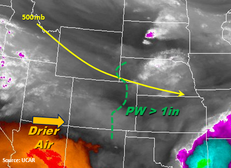
Moisture rich upslope flow is expected to initiate thunderstorms over the higher terrain early this afternoon. Storm coverage will widespread east of the Continental Divide. As storms move off the mountains, they will initially favor the high terrain of the Palmer and Raton Ridge and have storm motion to the east/southeast. The storms are expected to quickly form into widespread, slow-moving convection over the eastern plains and be amplified by a mid-level distrubance. Heavier rainfall is likely near the highest instability, which will be located where daytime heating is the greatest throughout the day. Small hail and gusty winds may be present with the more severe storms. Over the mountains, rainfall rates greater than 1 inch are likely over the Southeast Mountains. Threats include mud flows, debris slides and flash flooding especially over burn scars. Over the far eastern plains, localized 24-hour rainfall amounts over 4.5 inches may be possible. Threats include small stream and arroyo flooding, field ponding and road flooding. The threat for the eastern plains last into the overnight hours, and the cluster of storms is expected to exit the state around 3AM. Lingering showers and cloud cover over the plains and southeastern mountains are likely Monday morning.
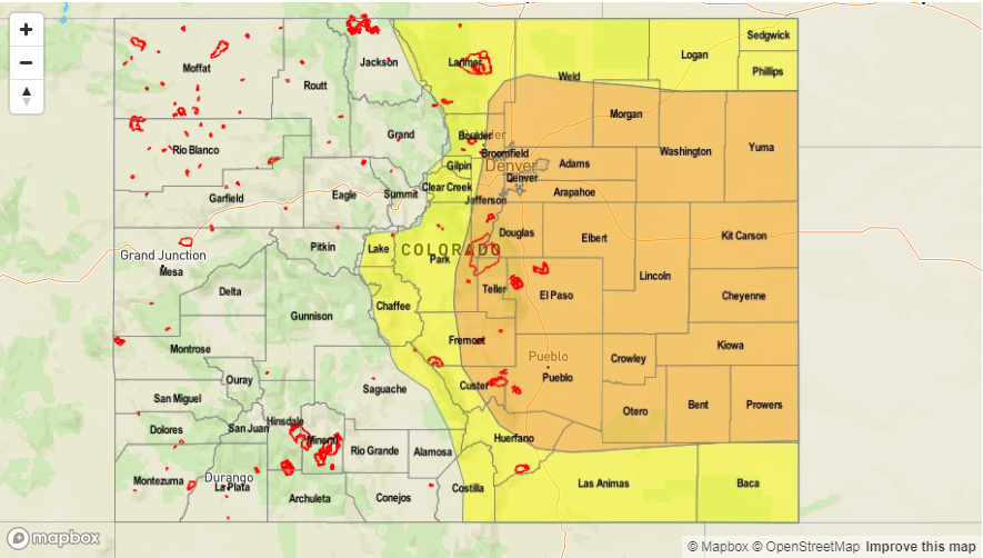
Today’s Flood Threat Map
For more information on today’s flood threat, see the map below (hover over threat areas for more details). For Zone-Specific forecasts, scroll below the map.

Zone-Specific Forecasts:
Front Range, Urban Corridor, Palmer Ridge, Northeast Plains, Southeast Mountains, Raton Ridge, Southeast Plains:
Low-level clouds this morning becoming partly sunny to fully sunny this afternoon. Expecting scattered showers and thunderstorms to develop over the mountains around 1-2PM and heavier convection over the plains lasting overnight. Max 1-hour rainfall up to 2.3 inches (east), 1.2 inches (west). Localized max 24-hour rainfall over 4.5 inches on the eastern plains cannot be ruled out. A Moderate flood threat has been issued today, and it is an overnight threat for the eastern plains.
Primetime: 1:30PM to 3AM
Northwest Slope, Grand Valley, Southwest Slope, Northern Mountains, Central Mountains, San Juan Mountains, San Luis Valley:
Sunny and near normal temperatures over the NW corner of the state. Scattered thunderstorms expected throughout the afternoon over the San Juan Mountains and Central Mountains with 24-hour totals up to 1.5 inches. Max 1-hour rainfall up to 0.6 inches (north) and 0.8 inches (south). There is no flood threat for today.
Primetime: 1PM to 10PM