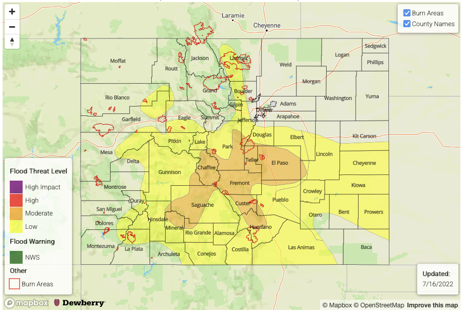
Issue Date: Saturday, July 16th, 2022
Issue Time: 9:55AM MDT
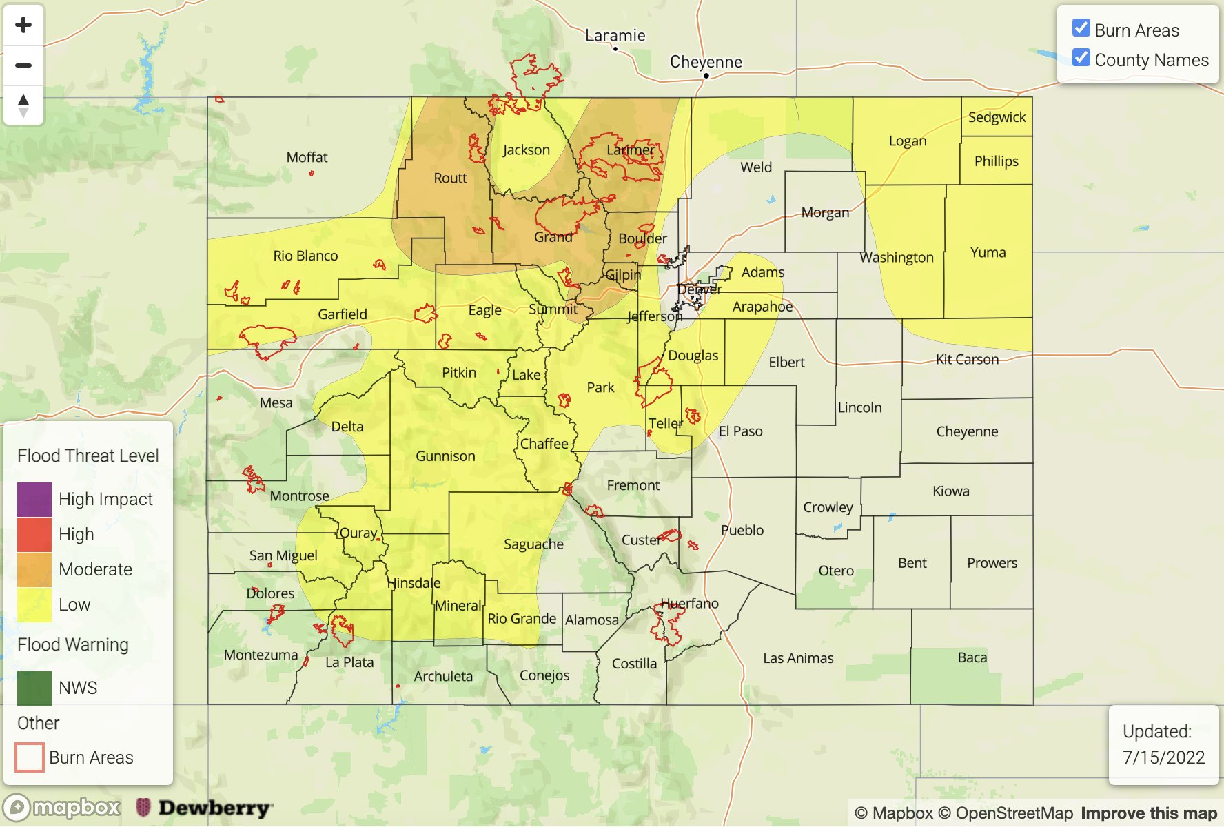
— A MODERATE flood threat has been posted for parts of the Palmer Ridge, Central Mountains, San Juans and Southeast Mountains
— A LOW flood threat has been posted for parts of the Front Range, Southeast Plains, Southwest Slope, Raton Ridge and San Luis Valley
— Fire-Burn Forecast Summary: 4 burn areas under MODERATE threat; 5 burn areas under LOW threat; click HERE for more info
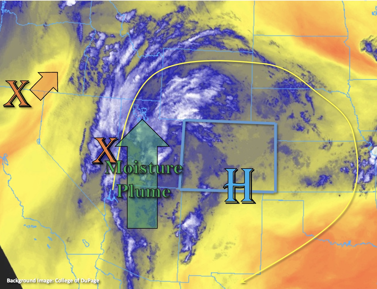
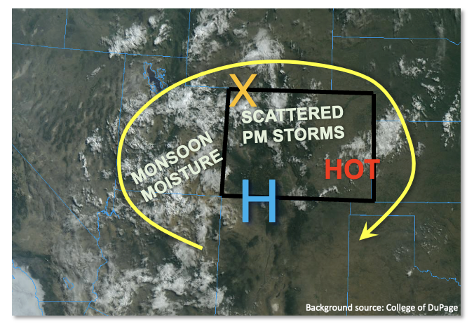
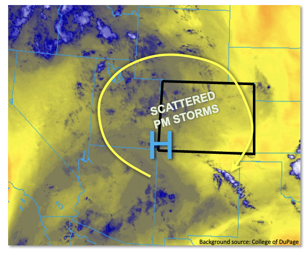
As shown in the visible satellite image, below, a relatively persistent monsoonal upper-level flow pattern continues over Colorado and the Four Corners today. However, it is the moisture content that is most noteworthy, and will once again drive an elevated flood threat today. With this morning’s Grand Junction PW coming in at 1.22 inches (~95th percentile), very efficient rainfall rates are expected once again today. Further east, Denver’s PW was once again unfortunately missing due to the nationwide helium shortage, but soundings at North Platte, NE (PW 1.42 inches; 90th percentile) and Dodge City, KS (PW 1.26 inches; 75th percentile) all suggest well above normal moisture content across all of Colorado. Surface moisture also continues to be very impressive with morning dewpoint temperatures in the 50s F over central and western Colorado, while readings up to 70F were noted over the Northeast Plains agricultural belt this morning!
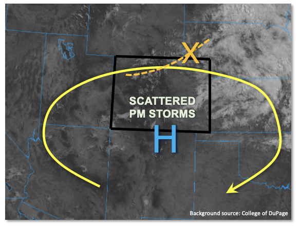
In terms of forcing today, we have clearing skies this morning as the departing cloud deck and associated disturbance from yesterday’s storms continues to move out of the state. Subsidence is notable on the western side of this feature (see “X” in visible image below) and will affect northern Colorado today, limiting storm activity to just the preferred higher elevation areas around the Continental Divide. Further south, with plenty of sunshine, weak steering flow and abundant moisture: we all know the drill. Instability up to 900 J/kg CAPE will fuel scattered to numerous will spark by early afternoon over mainly the southern Front Range, Palmer Divide, Central Mountains and San Juan Mountains. With a large cloud warm layer expected (i.e. tropical-style raindrop generation), very heavy rainfall will be possible over the 30-60 minute duration today, warranting a general LOW flood threat. Over parts of the Central Mountains, Palmer Divide and San Juan Mountains, higher coverage of storms warrants a MODERATE flood threat as multiple storm passages could occur over the same location.
Further east, storms will form another complex today as they head east-southeast off the Palmer Divide later this afternoon. With marginal instability, heavy rainfall should be limited to the 60-minute duration but a LOW flood threat is warranted all the way to the KS border as there is a sufficient chance that isolated storm cores will produce rain rates exceeding Flash Flood Guidance for the area.
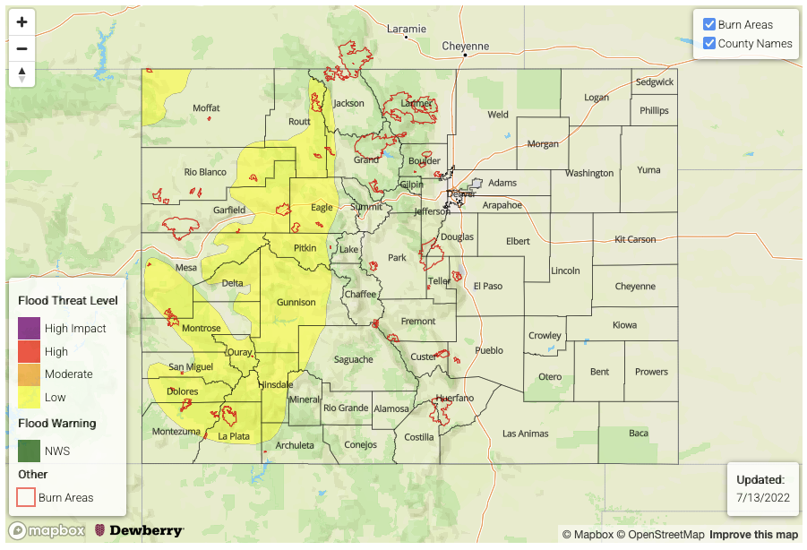
Today’s Flood Threat Map
For more information on today’s flood threat, see the map below. If there is a threat, hover over the threat areas for more details, and click on burn areas to learn more about them. For Zone-Specific forecasts, scroll below the threat map.
Zone-Specific Forecasts:
Southeast Plains, Front Range, Northern Mountains, Central Mountains, San Juan Mountains, Southwest Slope, San Luis Valley, Palmer Ridge, Southeast Mountains & Raton Ridge:
Becoming partly to mostly cloudy with scattered to numerous showers and storms developing by early afternoon over the higher terrain. Max 30-min rain rate up to 1.8 inches (east) and 1.5 inches (west) with max 60-min rain rates up to 2.5 inches (east) and 2.2 inches (west). Highest storm coverage will occur over the Palmer Ridge, northeast San Juan Mountains and Southeast Mountains, where a MODERATE flood threat is warranted. Flash flooding, debris slides and mud flows will be possible especially over steeper terrain. Small creeks and streams will also be prone to riverine flooding. Elsewhere a LOW flood threat is in place for mainly isolated flash flooding, with debris slides and mud flows also possible.
Primetime: 12PM to 9PM (west), 2PM to midnight (east)
Northeast Plains & Urban Corridor:
Partly cloudy then isolated to widely scattered showers and storms possible this afternoon. Max 30-min rain rate up to 0.7 inches possible. Outside of nuisance field and road ponding of rainwater, flooding is NOT expected today.
Primetime: 12PM to 8PM
Grand Valley & Northwest Slope:
Mostly sunny early then isolated showers and storms possible this afternoon, especially over the foothills. Max 30-min rate up to 0.5 inches possible but flooding is NOT expected today.
Primetime: 11AM to 7PM