Issue Date: Friday, July 15th, 2022
Issue Time: 10:25AM MDT
— A MODERATE flood threat has been issued for the Northern Mountains and portions of the Northwest Slope and Front Range
— A LOW flood threat has been issued for the Central Mountains, San Juan Mountains, Urban Corridor and Northeast Plains
— Fire-Burn Forecast Summary: 3 burn areas under HIGH threat, 4 burn areas under MODERATE threat, 3 burn areas under LOW threat; click HERE for more info
A very active rainfall day is on tap for Colorado with an abundance of monsoon moisture forecast across the state (blue and white in the water vapor imagery below). PW at Grand Junction was measured at 1.2 inches, which is right around the maximum moving average for peak monsoon season. Currently, some mid-level lift is combining with the copious amount of moisture to produce some scattered showers and weak storms over western Colorado. Additional mid-level lift (orange “X’s”) is forecast to move clockwise around the High over the next couple of days, which paired with daytime heating will help to spark scattered to numerous thunderstorms over western Colorado, the mountains and Northeast Plains today.
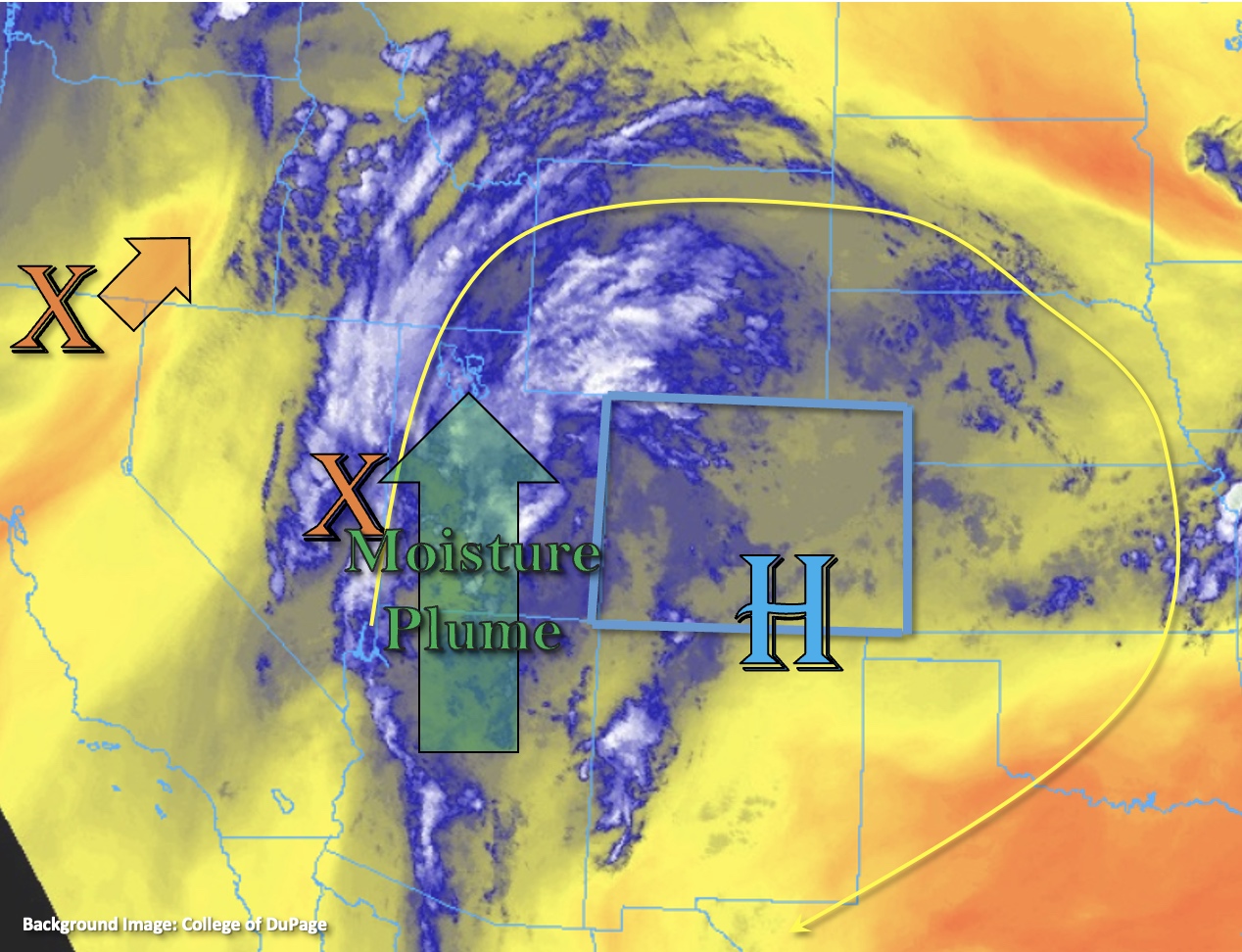
As mentioned above, surface moisture is quite high over the state this morning with an increase in dew points between 3-5°F. There wasn’t a sounding at Denver, but dew points along the I-25 Corridor are in the 50°Fs with mid to upper 50°Fs over the eastern plains. While some of this moisture may mix out along the Urban Corridor, there should still be plenty for scattered rainfall as storms roll off the mountains and develop over the ridges. A LOW flood threat has been issued for areas near the elevated ridges with isolated, heavy rainfall possible.
Ongoing cloud cover this morning will likely help to limit the instability that can build over the Central Mountains and western high terrains, but pockets of moderate instability could still develop and numerous rounds of rainfall are anticipated. A LOW flood threat has been issued for this reason. Better chance for heavy rainfall today is over the Northern Mountains and Front Range where more instability can form with clearer skies. There should be just enough shear that a couple stronger thunderstorms are possible with the main threat being outflow winds and hail. A MODERATE flood threat has been issued. The flood threat should end by this evening over the mountains, although some overnight precipitation is likely across the Northern Mountains.
One last area of concern for flooding is the Northeast Plains tonight where a couple of stronger thunderstorms are possible as storms move into the area with WSW steering flow. It looks like the low-level jet could kick in, which would help fuel these storms and possibly grow them into a MCS if they can reach the area around sunset. A LOW flood threat has been issued with the storms likely winding down after a couple hours with instability dropping off with the setting sun.
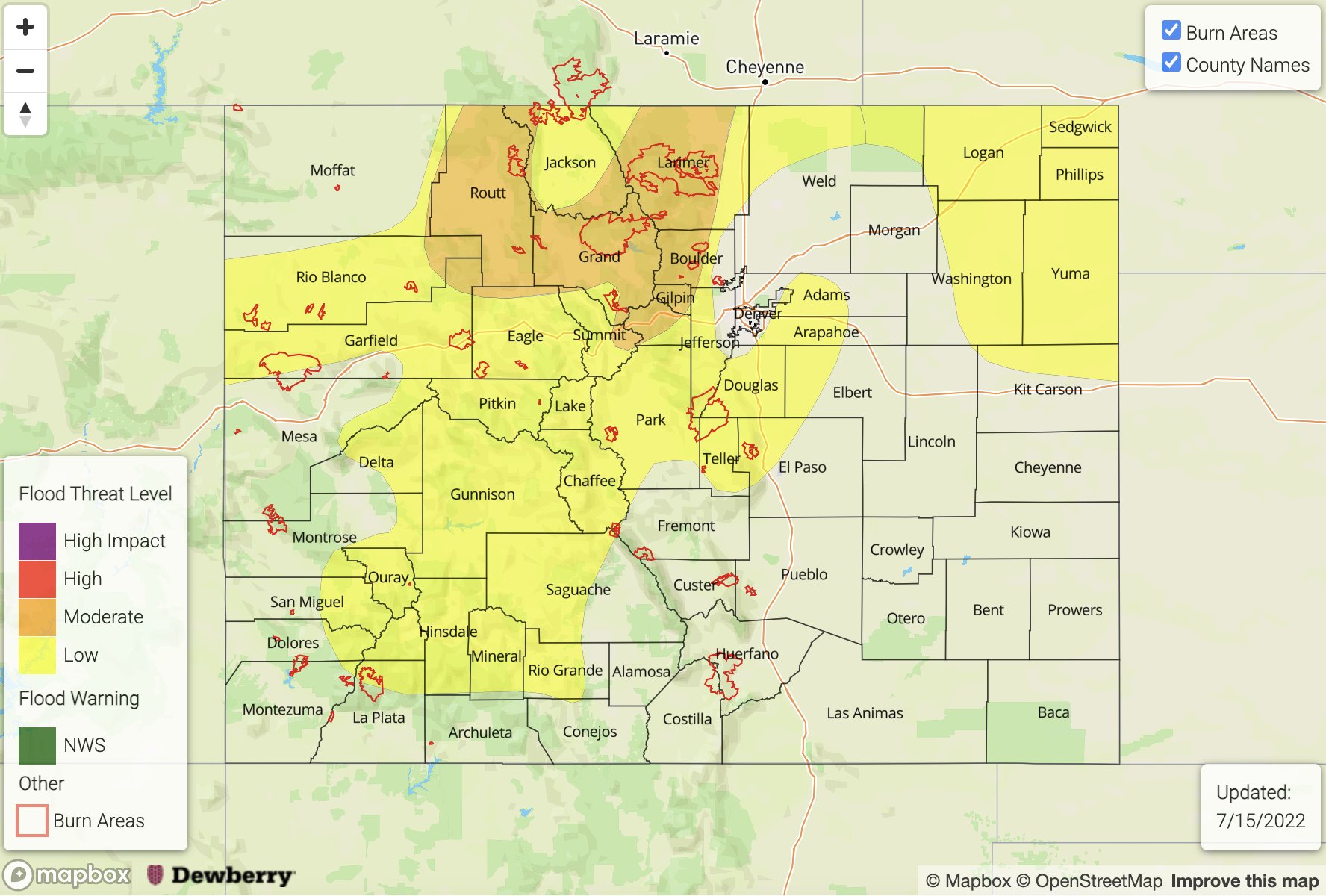
Today’s Flood Threat Map
For more information on today’s flood threat, see the map below. If there is a threat, hover over the threat areas for more details, and click on burn areas to learn more about them. For Zone-Specific forecasts, scroll below the threat map.
Zone-Specific Forecasts:
Front Range, Central Mountains, Northern Mountains, Northwest Slope, Grand Valley, Southwest Slope & San Juan Mountains:
Numerous storms are forecast over the northern high terrains today with max 30-minute rain rates up to 1.25 inches and isolated 1 to 2-hour storm totals up 2 inches possible. This could cause mud flows and debris slides over steeper terrains as well as local road flooding. A MODERATE flood threat has been issued. In addition to heavy rainfall, stronger thunderstorms may produce moderate sized hail and wind gusts up to 60 mph. Further south, storms should be more scattered with isolated max 30-minute rain rates up to 1 inch and isolated storm totals up to 1.5 inches possible. A LOW flood threat has been issued. The flood threat should begin to wind down this evening although some overnight showers are possible over the Northern Mountains as additional mid-level energy moves over the area.
Primetime: 11AM to Ongoing
Palmer Ridge, Northeast Plains, Urban Corridor, Southeast Mountains, San Luis Valley, Raton Ridge & Southeast Plains:
Best chance for heavy rainfall across the Urban Corridor will be near the elevated ridges. Isolated areas of max 30-mintue rain rates up to 1.1 inches will be possible. This could cause road and low-lying area flooding as well as field ponding. As storms move into the Northeast Plains, upscale growth is anticipated with hail and strong winds also likely to develop if this occurs. Max 1-hour rain rates up to 2 inches will be possible this evening, which could cause some road flooding and field ponding. A LOW flood threat has been issued. Thunderstorms over the plains should begin to dissipate by midnight.
It should remain relatively dry further south, but some widely scattered storms will be possible over the Southeast Mountains. Max 30-minute rain rates up to 0.5 inches will be possible, so flooding is NOT expected for this area.
Primetime: 1:30PM to 12PM