Issue Date: Thursday, July 14th, 2022
Issue Time: 10:35AM MDT
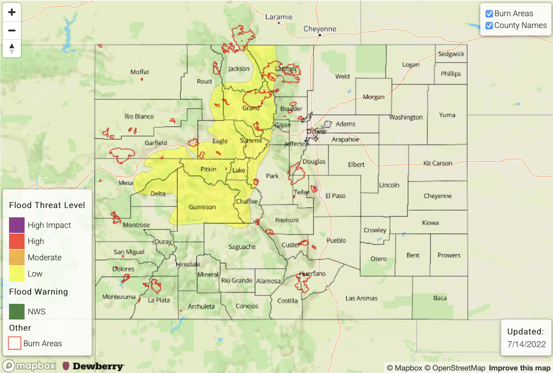
— A LOW flood threat has been posted for parts of the Northern Mountains, Front Range and Central Mountains
— Fire-Burn Forecast Summary: 6 burn areas under MODERATE threat; 2 burn areas under LOW threat; click HERE for more info
A persistent monsoonal pattern continues across Colorado with an upper level ridge importing fresh moisture into the state from the southwest (see visible satellite image below). While the pattern seems similar from the big picture, on a local level, we continue to look closely at slight changes in moisture, cloud cover and steering flow to understand the flood threat. This morning, Grand Junction’s PW measured 1.02 inches, a slight increase from yesterday’s 0.96 inches and well above the seasonal normal of 0.75 – 0.8 inches. Dewpoint temperatures are also 3-8F higher over north-central and northwest Colorado suggesting the continued potential for heavy rainfall there. With instability up to 1,000 J/kg CAPE expected again this afternoon, a LOW flood threat is warranted for portions of the Central and Northern Mountains as well as the Front Range along the Continental Divide. Isolated maximum 30-60 minute rain rates are expected to exceed flash flood guidance over this steeper terrain. The main caveat today is the presence of cloud cover and ongoing light showers/sprinkles associated with a weak mid-level disturbance (see “X” in the satellite image below). This is expected to limit instability over the Northwest Slope and parts of the Northern Mountains, keeping moderate/heavy rain rates limited to the 15-30 minute duration that is unlikely to produce flooding.
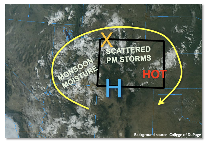
Further east, the moisture profile is not as threatening with more dry air expected in the sub-cloud layer reducing the max rain rates and promoting the threat of gusty winds. To the south, wind shear will be so weak that storm updrafts are unlikely to sustain themselves long enough to produce a flood threat.
Finally, over southeastern and eastern Colorado, very hot temperatures are expected once again as little cloud cover is anticipated.
Today’s Flood Threat Map
For more information on today’s flood threat, see the map below. If there is a threat, hover over the threat areas for more details, and click on burn areas to learn more about them. For Zone-Specific forecasts, scroll below the threat map.
Zone-Specific Forecasts:
Northern Mountains, Central Mountains, Front Range, Grand Valley, San Juan Mountains, Southwest Slope, San Luis Valley & Northwest Slope:
Partly cloudy early then mostly cloudy with scattered to numerous showers and storms expected early this afternoon, lasting into the evening. Max 30-minute rain rates up to 1.0 inch and max 1-hour rain rates up to 1.4 inches warrant a LOW flood threat for mainly higher elevation locations (7,500ft+) of the northern and central parts of the region. Isolated flash flooding, mud flows and debris slides will all be possible, especially over the steeper terrain. Further south, max 30-minute rain rates up to 0.7 inches are possible, but flooding is NOT expected.
Primetime: 12PM through 8PM
Northeast Plains, Southeast Plains, Urban Corridor, Palmer Ridge, Southeast Mountains & Raton Ridge:
Mostly sunny early then partly cloudy with isolated to widely scattered showers and thunderstorms expected this afternoon and evening. Highest coverage will be closer to the mountains and over the Northeast Plains, with little activity expected further southeast over the plains. Max 30-minute rain rates up to 0.7 inches are possible with max 1-hour rainfall up to 1.5 inches over parts of the Northeast Plains. Some nuisance ponding of rain water could occur, but flooding is NOT expected today. Gusty winds up to 40mph are also possible especially later in the afternoon over the Northeast Plains as storms grow into a larger complex.
Primetime: 2PM through 10PM