Issue Date: Wednesday, July 20th, 2022
Issue Time: 10:45AM MDT
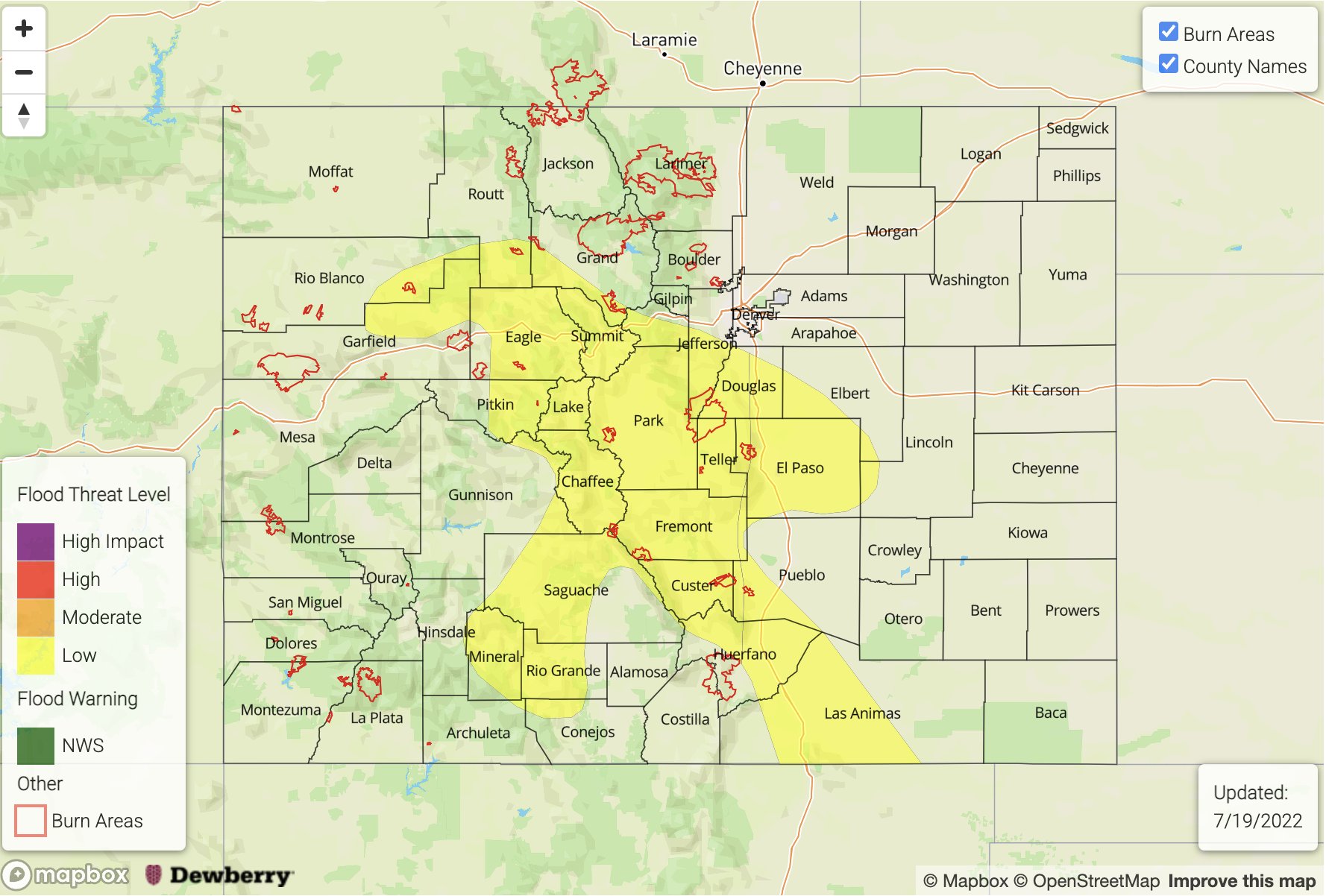
— A MODERATE flood threat has been posted for parts of the Palmer Ridge, Southeast Mountains and Raton Ridge
— A LOW flood threat has been posted for parts of the Southeast Plains, Central Mountains, San Juan Mountains and San Luis Valley
— Fire-Burn Forecast Summary: 3 burn areas under MODERATE threat; 3 burn areas under LOW threat; click HERE for more info
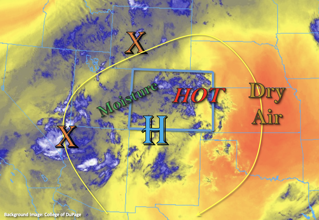
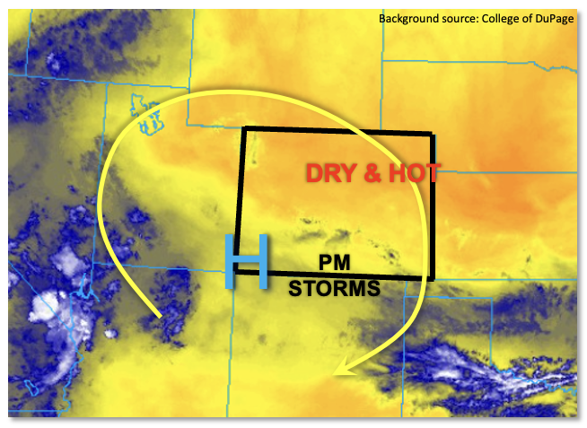
An active weather pattern remains in store today for most of central and southern Colorado as plenty of monsoonal moisture remains overhead. This morning’s PW at Grand Junction measured 0.94 inches, down slightly from yesterday but still well above seasonal normal. The Denver sounding was again unfortunately unavailable, but estimates suggest values in the 0.9 – 1.0 inch range. PW in the 1.0 – 1.3 inch range is estimated across southeast Colorado. Near the surface, dewpoint temperatures continue to measure well above 50F for most elevations below 8,000 feet over central and southern Colorado. Some boundary layer drying has occurred over northern areas, and rain chances will be much lower there.
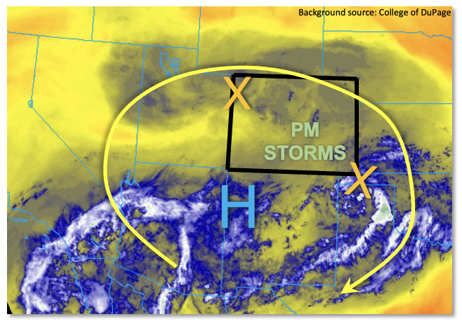
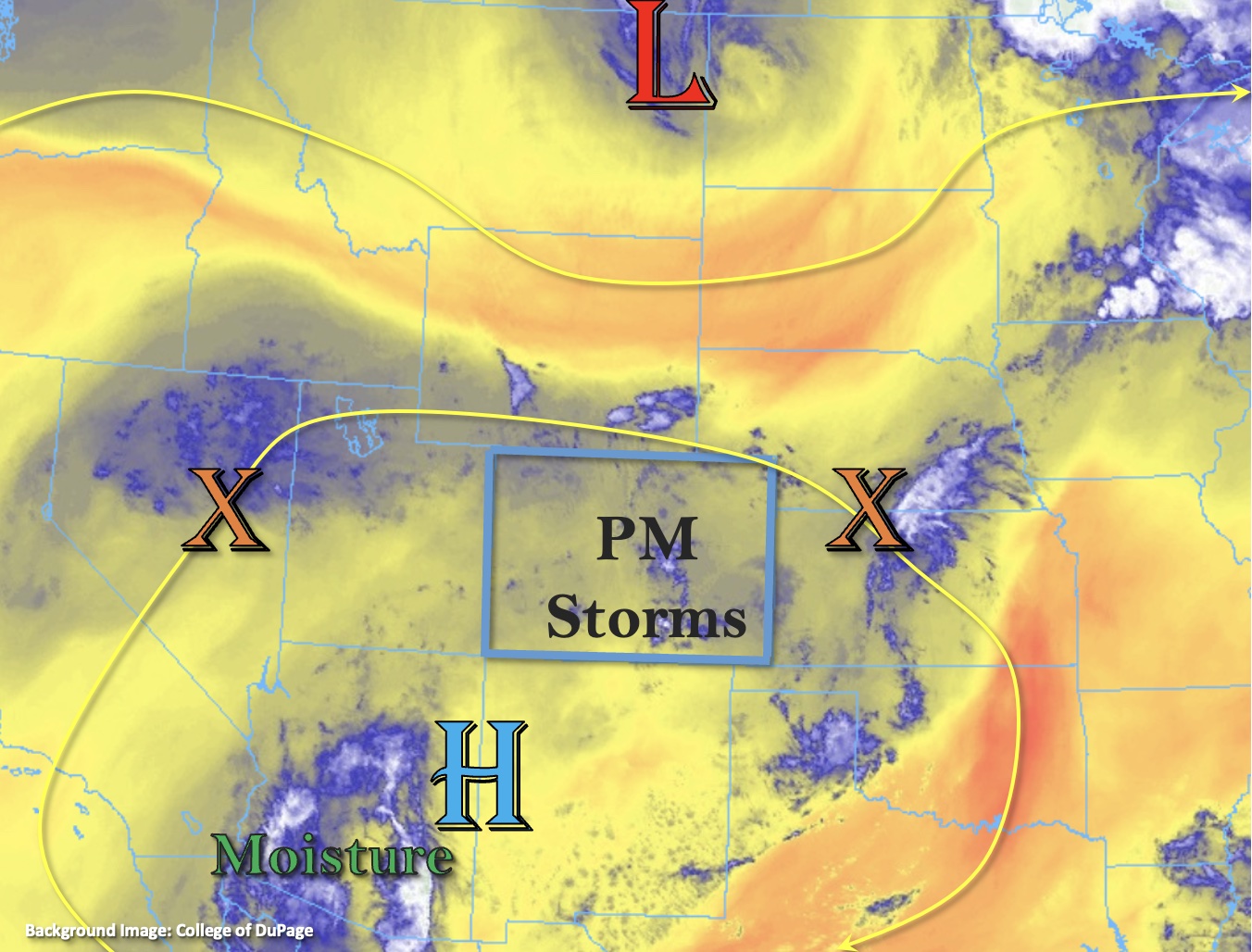
As shown in the water vapor image, above, clockwise flow around the monsoonal upper-level ridge places Colorado in WNW steering flow as of this morning. One disturbance, associated with yesterday’s storms is currently leaving the southeast part of the state, producing subsidence in its wake. This will delay convection over the Southeast Plains until the later afternoon hours. Another disturbance is noted along the UT/CO border. This, along with our usual diurnal upslope circulation, will act as the main forcing of afternoon and evening storms over our higher terrain, spilling into the foothills and plains thereafter. CAPE instability up to 1,100 J/kg will be available this afternoon, which given the boundary layer moisture will be plenty for sustaining heavy rainfall. Steering flow will be in the 20+ mph range north of I-70 but in the 15-20mph range over southern areas, promoting the potential for heavy rain accumulation. Steering flow will also veer to be more NW or even NNW throughout the day, which will allow for a better chance for storms to interact and anchor to the higher terrain. Because of this, a MODERATE flood threat is warranted for climatologically favored parts of the state including the Palmer Ridge extending south through the I-25 corridor to New Mexico. Antecedent wet soils will also help promote more efficient runoff rates. In surrounding areas, a LOW flood threat has been posted.
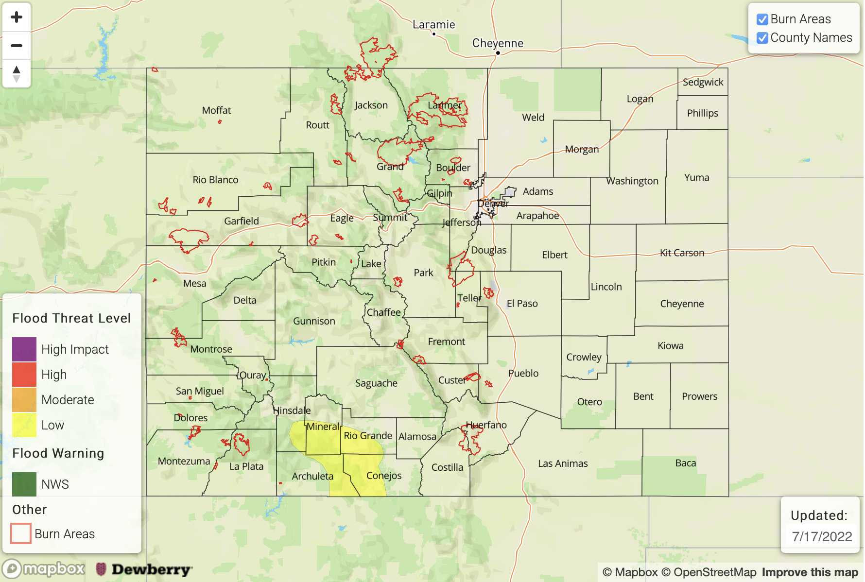
Today’s Flood Threat Map
For more information on today’s flood threat, see the map below. If there is a threat, hover over the threat areas for more details, and click on burn areas to learn more about them. For Zone-Specific forecasts, scroll below the threat map.
Zone-Specific Forecasts:
Southeast Plains, Front Range, Urban Corridor, Northeast Plains, Palmer Ridge, Central Mountains, San Juan Mountains, San Luis Valley, Southeast Mountains & Raton Ridge:
Mostly sunny early then partly to mostly cloudy with scattered to numerous showers and storms developing by early afternoon. Max 30-min rain rates up to 1.2 inches (above 6,000 feet) and 1.6 inches (eastern areas below 6,000 feet) with max 1-hour rain rates up to 1.8 inches (above 6,000 feet) and 2.5 inches (eastern areas below 6,000 feet.
A MODERATE flood threat has been posted for the foothills and higher terrain over the Palmer Ridge and Southeast Mountains where antecedent wet soils will further enhance rainfall runoff. A LOW flood threat has been posted for surrounding areas. Isolated flash flooding, debris slides and mud flows will be possible over the higher terrain. Over the Moderate threat area, high flows will be possible on small creeks and streams, as well as normally dry arroyos. Further east, the main threat will be isolated flash flooding as well as road flooding.
Severe weather will be possible with the strongest cells over the Southeast Plains today, with the main threats being damaging wind and possibly large hail.
Primetime: 12PM through midnight
Northern Mountains, Grand Valley, Southwest Slope & Northwest Slope:
Mostly sunny early then partly cloudy with isolated to widely scattered showers and storms possible this afternoon and evening. Max 30-min rain rates up to 0.5 inches possible. Aside from some nuisance ponding, flooding is NOT expected today.
Primetime: 12PM through 8PM