Issue Date: Tuesday, July 19th, 2022
Issue Time: 8:45AM MDT
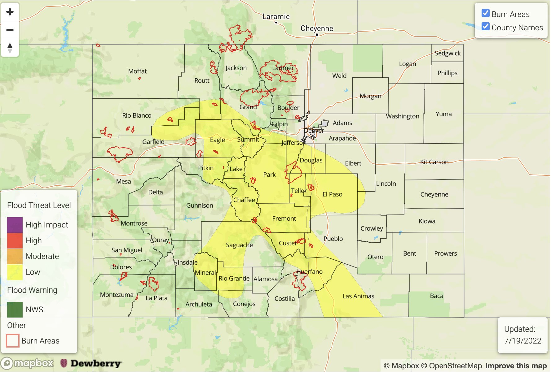
— A LOW flood threat has been issued for the Central Mountains, Raton Ridge and portions of the Northwest Slope, Northern Mountains, Central Mountains, Front Range, Southeast Mountains, San Juan Mountains, Urban Corridor, Palmer Ridge and Southeast Plains
— Fire-Burn Forecast Summary: 4 burn areas under LOW threat; click HERE for more info
Today is expected to look similar to yesterday on the rainfall front with a few minor changes to the details. The passing Low to our north has pushed the center of the High south of the Four Corners region, which should keep steering flows mostly westerly with a bit more of a northerly component over eastern Colorado today. Storm motion over the northern and central portion of the state will still be rather quick with a mid-level speed just north of the border, but training storms look to be more likely, which could help increase local accumulations. This minor movement of the High should help to keep afternoon high temperatures slightly less than yesterday, although it’s still going to be quite hot with the 5920mb contour overhead.
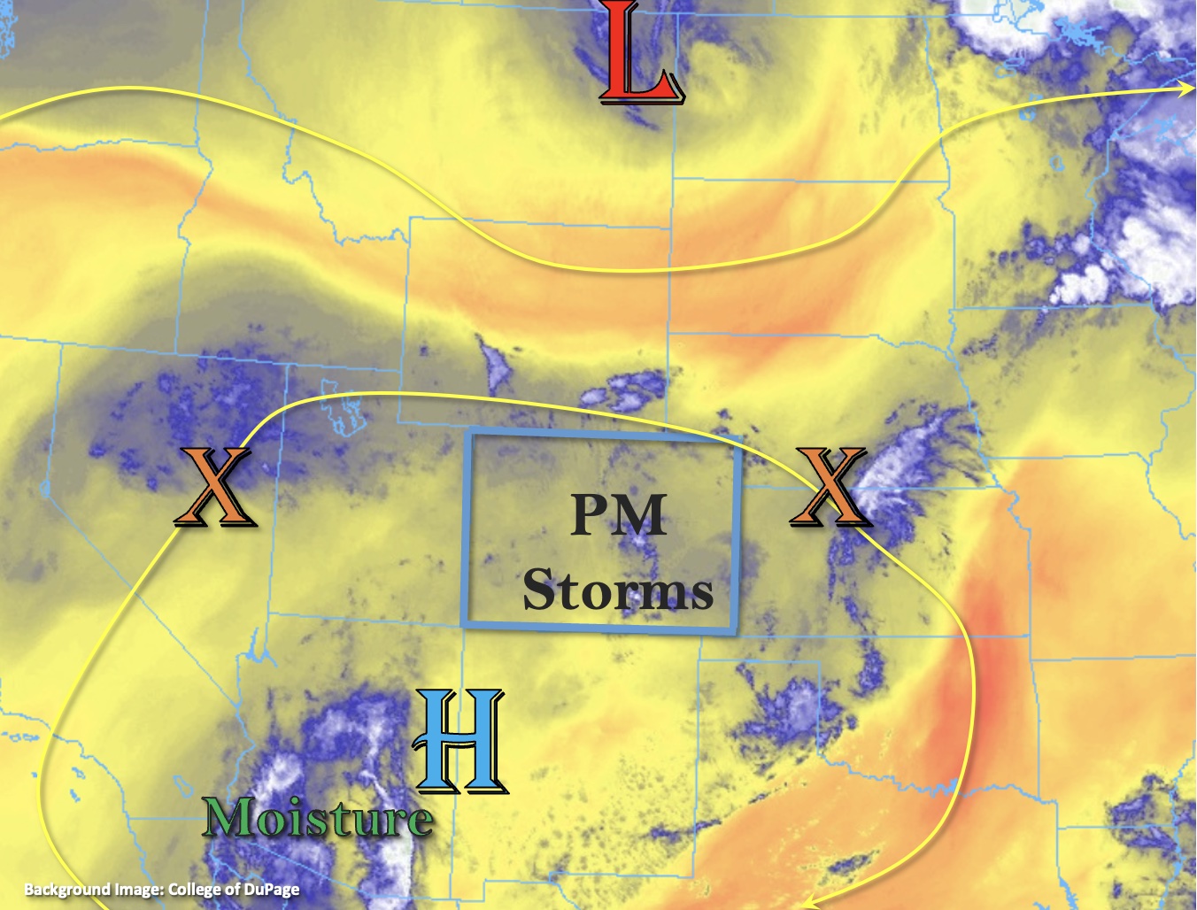
As far as moisture, PW at Grand Junction was measured at 1.02 inches with a dew point of 52°F, so both are slightly higher than this time yesterday. Generally, PW values look to have increased over northern Colorado as well as over the far eastern plains. There’s still no sounding data at Denver, but dew points along the I-25 Corridor are a few degrees less than yesterday with PW likely in the 0.7-0.8 inch range. That means there is plenty of residual and incoming moisture rotating around the High and into the state for scattered storms to occur.
As upslope flow begins by late morning, storms should have no problem kicking off over the high terrains by early afternoon with plenty of moisture and sunshine. Outside of the Flat Tops and Grand Mesa regions over western Colorado, storms coverage should be mostly confined to the central and southern mountains today with some spillover anticipated into the adjacent eastern plains. Slightly slower steering flows south and training storms over central Colorado will cause a LOW flood threat to be issued. Some mid-level drying was noted in the Grand Junction sounding, so the stronger thunderstorms that do develop may be more likely to produce hail and strong outflow winds today. The flood threat over the adjacent plains should be limited to the elevated ridges with most storm activity winding down a couple hours after sundown.
Today’s Flood Threat Map
For more information on today’s flood threat, see the map below. If there is a threat, hover over the threat areas for more details, and click on burn areas to learn more about them. For Zone-Specific forecasts, scroll below the threat map.
Zone-Specific Forecasts:
Central Mountains, Northern Mountains, Front Range, Southeast Mountains, Palmer Ridge, San Juan Mountains, Northwest Slope, Raton Ridge & Urban Corridor:
In the wake of the passing Low, minimal storm activity is anticipated over the Northern Mountains and northern Front Range this afternoon. A couple rounds of storms today along with slower steering flows (south) will increase the flood threat for the central and southern high terrains. Max 30-minute rain rates up to 1.1 inches and isolated storm totals up to 1.6 inches will be possible. Over the adjacent elevated ridges, max 1-hour rain rates up to 1.25 inches will be possible with the majority of the rainfall falling in 30-40 minutes. Stronger thunderstorms that develop today will be more likely to produce hail and damaging outflow winds, especially over the adjacent plains. A LOW flood threat has been issued with field ponding, road flooding and isolated mud flow/debris slides (steeper terrains) possible. Lighter showers may linger over the mountains tonight.
Primetime: 12:30PM to 11PM
Grand Valley, Southwest Slope, Southeast Plains, Northeast Plains & San Luis Valley:
Best chance for isolated rainfall today will be near the Grand Mesa and far eastern plains (central/south). However, there is a chance for some rainfall in the SLV with SE steering flows pushing storms off the San Juan Mountains into the valley. Max 30-mintue rain rates up to 0.5 inches (west) and 0.25 inches (SLV) will be possible with max 1-hour rain rates up to 1.25 inches forecast east. Strong outflow winds will be possible with any storms that develop as well as hail (most likely east). Flooding is NOT expected today.
Primetime: 12:30PM to 9PM (west/central); 3PM to 1AM (east)