FTB 05-22-2018: Widespread Thunderstorm and Shower Activity for Western Colorado and Mountainous Terrain

Issue Date: Tuesday, May 22, 2018
Issue Time: 9:10AM MDT

— Flooding is NOT expected today

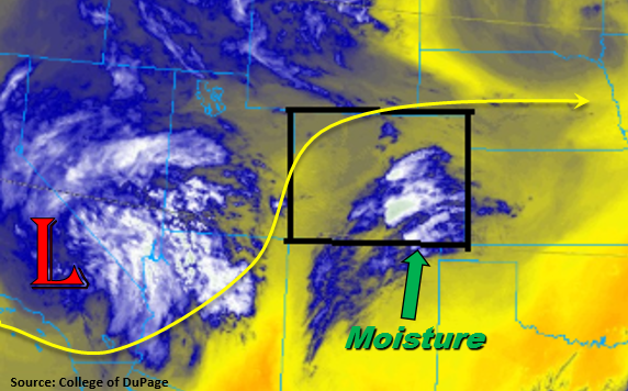
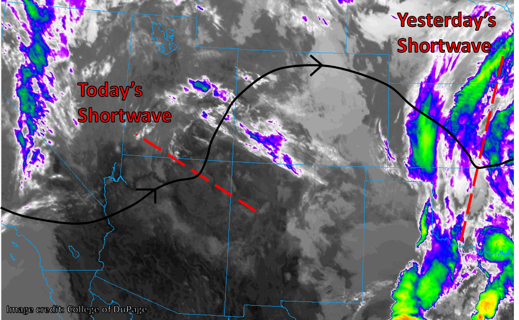
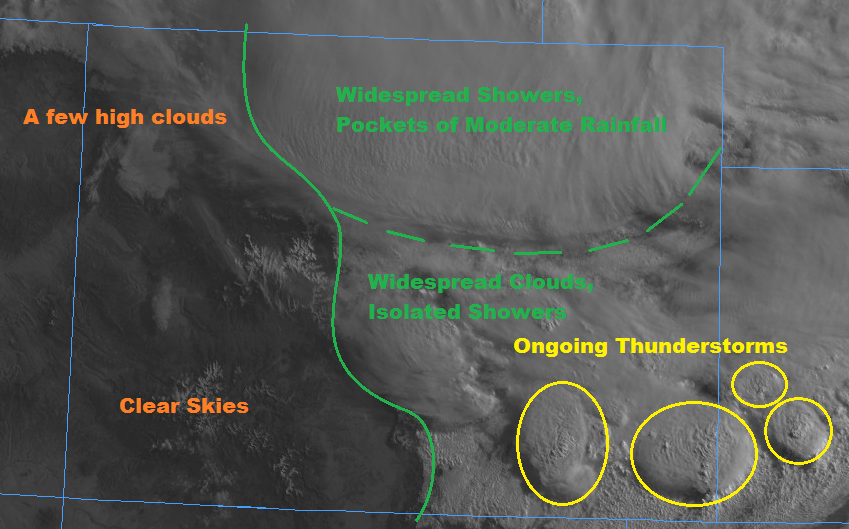
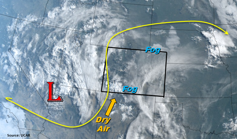
Looking at the visible imagery below, we can see a lot of low clouds and fog over the majority of Colorado with much clearer skies over the Grand Valley and Northwest Slope. These clear skies will help build instability over this area for thunderstorm development this afternoon. The current fog is expected to burn off this morning as daytime heating occurs after sunrise. Today, the closed low over Nevada begins to move to the north/northeast and become an open wave. The release of shortwaves and upper support will aid in triggering widespread thunderstorms west of the Continental Divide this afternoon into this evening. Southwest flow, marked below, will pull in drier air over southwest Colorado, so the highest rainfall totals (west) will be limited to the northwest corner. Storm motion will be north/northwest at 20 knots, so this is another reason heavy rainfall over one area is not expected. Accompanying the stronger thunderstorms will be gusty winds, small hail and lightning.

East of the Continental Divide, thunderstorm development will start over the Southeast Mountains and spread north into the Front Range by the early afternoon. A few storms will roll off the Southeast Mountains to give the Southeast Plains some rainfall as well. However, the best moisture is confined to the CO/KS border, so don’t expect any flooding this afternoon but rather gusty winds and small hail. Over the northern Front Range, upslope flow will help pull in some decent moisture from the east. Storm motion will be more northerly, so storms will be confined to the west today and only affect the Urban Corridor. Highest moisture (dew points in the upper 40s) will occur over the northern Front Range/Urban Corridor, so expecting the highest totals for the day in this region. After sundown, thunderstorm activity will begin to die down with all activity ending around 10PM. Flooding is not expected today.

Today’s Flood Threat Map

For more information on today’s flood threat, see the map below. For Zone-Specific forecasts, scroll below the map.

Zone-Specific Forecasts:

Raton Ridge, Southeast Mountains, Southeast Plains, San Luis Valley, San Juan Mountains, Southwest Slope:

Storms will begin to fire over the higher terrains by noon (west) and 1PM (east). Best coverage will be over the eastern high terrains due to entrainment of dry air to the west. Max 1-hour rain rates over the higher terrains will be 0.15 inches/hour. Over the Raton Ridge and Southeast Plains, 1-hour max rain rates up to 0.75 inches are possible. Rain rates aren’t expected to meet flood criteria over the burn scars on the Southeast Mountains (<0.5 inches/hour). Thus, flooding is not expected today.

Primetime: 11AM to 9PM

Northwest Slope, Central Mountains, Grand Valley, Northern Mountains:

Widespread thunderstorms and showers expected this afternoon. Max 1-hour rain rates between 0.4 and 0.5 inches/hour are possible under the stronger storms over the Northwest Slope. Small hail and gusty winds (up to 50mph) are likely with all thunderstorms due to limited moisture. Flooding is not expected today.

Primetime: 1PM to 10PM

Palmer Ridge, Front Range, Urban Corridor, Northeast Plains:

Isolated showers and thunderstorms are expected over the higher terrains this afternoon and may spill into the Urban Corridor. Heavier rainfall will be confined further north where 1-hour rain rates could be up to 0.7 inches/hour under the stronger storm cores. There is no flood threat today.

Primetime: 2PM to 10 PM

FTB 05-21-2018: Much Needed Rain for Southern Colorado

Issue Date: Monday, May 21, 2018
Issue Time: 10:05AM MDT

— Flooding is NOT expected today

Finally getting to warm up a bit today with more of a ridging pattern after a cool weekend for all. Northeast Colorado had quite the rain-filled weekend with the largest 3-day total (estimated by radar) just over 4 inches in Weld County. Today south/southwest flow returns to the state as the low pressure digs into southern California. A jet forms around the base of the low that will bring upper level diffluence to southern Colorado. Also, marked in the water vapor imagery below are southerly winds. This will pull in moisture from New Mexico, but moisture is expected to be confined to the southern portion of the state. Upper dynamics and this moisture combine to trigger much needed rainfall into this region, which includes the San Luis Valley through this evening. Expect the best coverage over the higher terrains of the Southeast, Central and San Juan Mountains, but thunderstorms are also expected over the Southeast Plains later this afternoon and evening. Dew points are still on the lower end, so expect some gusty winds with storms that form and small hail under the stronger storms to the east. Recent burn scars over the Southeast Mountains may see an isolated shower. However, better moisture remains south, so rain totals should remain under 0.5 inches. Flooding is not expected today. For more details, please see the regional forecasts below.

Today’s Flood Threat Map

For more information on today’s flood threat, see the map below (hover over threat areas for more details). For Zone-Specific forecasts, scroll below the map.

Zone-Specific Forecasts:

Raton Ridge, Southeast Mountains, Southeast Plains, San Luis Valley, San Juan Mountains, Central Mountains, Southwest Slope:

Rain for southern Colorado is expected into this evening. Best coverage will be over the southern, high terrains with rain rates under the stronger storms in the 0.4 – 0.5 inches/hour range. Over the Southeast Plains and Raton Ridge, 1-hour rain rates up to 0.9 inches are possible near the New Mexico border. San Luis Valley 24-hour (isolated) totals could be up to 0.4 inches with local totals in higher terrains nearby up to 1 inch. Flooding is not expected today.

Primetime: 12PM to Midnight

Palmer Ridge, Front Range, Urban Corridor, Northeast Plains:

Isolated showers and thunderstorms are expected over the higher terrains this afternoon with best coverage further south. 1-hour rain rates could be up to 0.3 inches under stronger storms. An isolated thunderstorm could occur over the Palmer Ridge, but more gusty winds are expected than heavy rainfall with 1-hour totals up to 0.4 inches. There is no flood threat today.

Primetime: 2PM to 10 PM

Northwest Slope, Grand Valley, Northern Mountains:

A stray shower with trace amounts of rain could wander into the Grand Valley from the higher terrains this evening. However, with lower moisture over the north, the more likely scenario is partly cloudy skies this afternoon. Temperatures should warm up 5-10F when compared to yesterday.

FTB 05-20-2018: Quiet Morning for Most, then Evening Showers & Storms in/near the Mountains

Issue Date: 5/20/2018
Issue Time: 12:05 PM

NO flood threat today.

After a very wet last couple of days, the northeastern portions of Colorado should begin to dry out later today, and the mountainous regions of the state should see a round of showers and thunderstorms this evening. The upper-level disturbance that was responsible for some of yesterday’s precipitation is now off to the east (“Yesterday’s Shortwave” in the image below), taking the associated cluster of showers and storms with it. Today’s shortwave is currently situated in northern Arizona and, as indicated by the infrared satellite imagery, is producing little in the way of precipitation or cloud cover. However, as it approaches Colorado from the southwest today, it should tap into the moisture already in place, spawning a fresh round of precipitation.

Upslope flow has persisted this morning in the foothills east of the Continental Divide and the adjacent plains, producing low clouds and drizzle for many in the Urban Corridor. As we progress through the morning, these clouds should lift and burn off, leading to at least some sunshine for many across the state. Meanwhile, showers and storms should start over the higher terrain in the southwestern portion of the state by around noon, with development progressing northward and eastward throughout the day. Rainfall will be light or briefly moderate for most, but favored slopes may see a long-lasting rainfall event today with 24-hour totals approaching 2”. However, given the lower rainfall intensities expected, we do not expect to see a flood threat across Colorado today.

Today’s Flood Threat Map

For more information on today’s flood threat, see the map below (hover over threat areas for more details). For Zone-Specific forecasts, jump below the map.

Flood Threat Legend

Zone-Specific Forecasts

Grand Valley, Southwest Slope, San Juan Mountains, Southeast Mountains, Raton Ridge:

Sunny to begin with this morning, but clouds increasing as scattered showers and thunderstorms build during the afternoon. Valleys may remain largely dry, but rain may persist on favored south- and southwest-facing slopes well into the evening.

Rainfall rates: generally 0.05” – 0.20” per hour, may get as high as 0.25” – 0.50” per hour on favored slopes.

Primetime: 11AM to 10PM

 Northwest Slope, Northern Mountains, Central Mountains, Front Range:

The sun is out this morning west of the Continental Divide, with low clouds as a result of upslope flow east of the Divide. Expect this first round of cloudiness to lift throughout the morning before clouds build from the south and west with the convection kicked off by the approaching shortwave.

Rainfall rates: generally 0.05” – 0.25” per hour

Primetime: 1PM to 9PM

 Southeast Plains, San Luis Valley, Northeast Plains, Urban Corridor, Palmer Ridge:

Low clouds and drizzle to begin with over the western half of the plains this morning, with sunshine for the San Luis Valley and eastern reaches of the plains. A partly sunny and mild day is in the offing for most, with a small chance of a shower or storm rolling off the mountains and onto the adjacent plains. This chance is greatest for the Southeast Plains and Palmer Ridge, as well as southwestern portions of the Denver metro.

Rainfall rates: < 0.10” per hour, up to 0.25” per hour in an isolated thunderstorm

Primetime: 6PM to Midnight

FTB 05-19-2018: Unsettled Weather Continues, Moderate Flood Threat Issued

Issue Date: 5/19/2018
Issue Time: 8:10 AM

A MODERATE FLOOD THREAT IS FORECAST TODAY FOR PORTIONS OF THE NORTHEAST PLAINS.
A LOW FLOOD THREAT IS FORECAST FOR PORTIONS OF THE NORTHEAST PLAINS, URBAN CORRIDOR, AND FRONT RANGE.

Another day of unsettled weather conditions is in store for Colorado, and a quick peak at the visible satellite image below can help break down the forecast reasonably well. To the east of the solid green line, and to the south of the green-dashed line, widespread clouds are hanging around with a couple of ongoing thunderstorms. The thunderstorms are tapping into an axis of instability that exists across the area currently. This first group of thunderstorms should wind down over the next few hours, before a second round of thunderstorms kicks off in concert with the pocket of instability this afternoon/evening. One or two of the afternoon storms will be strong, producing hail, periods of heavy rain, and strong winds.

The main area of focus for the flood threat today will be north of the green-dashed line, where widespread showers with pockets of moderate rainfall are expected to persist throughout much of the day, winding down during the late evening hours. Over the Front Range and Urban Corridor, a few thunderstorms that develop further west will attempt to move overhead, which is the reason for their inclusion in the low flood threat area. Those storms will be capable of producing brief heavy rain; due to the heavy rain some locations experienced yesterday, they will be susceptible to a street/field flooding.

Finally, to the west of the green solid line, you’ll notice that the skies are mostly clear, which will allow for sufficient daytime heating today, setting the stage for afternoon/evening showers/thunderstorms. Low-level moisture is a bit on the low side, and precipitable water is ~0.5” (which is about average for the date) so no flood threat is warranted out west.

Today’s Flood Threat Map

For more information on today’s flood threat, see the map below (hover over threat areas for more details). For Zone-Specific forecasts, jump below the map.

Flood Threat Legend

Zone-Specific Forecasts

Front Range, Urban Corridor, Northeast Plains, and Palmer Ridge:

Cloudy and cool will be the name of the game today, with widespread showers expected across the Northeast Plains, with lesser coverage across the Front Range, Urban Corridor, and Palmer Ridge. A widespread 1-2” of rain fell across the Logan, Morgan, Washington, Phillips, and Sedgwick counties since yesterday afternoon, with a couple pockets upwards of 2.5”. This amount of rain, plus another 1-2” expected through this evening are the reasons behind the issuance of the low-to-moderate flood threat. The main impacts will be street/field flooding, and flooding of low-lying areas. For the Front Range and Urban Corridor, their inclusion in the low threat is due to the potential for afternoon/evening thunderstorms moving overhead from the west.

Northeast Plains: 0.5-1.0 inches/hour
Front Range, Urban Corridor, and Palmer Ridge: 0.4-0.7 inches/hour

Timing for Northeast Plains: Current – Midnight
Timing for Front Range, Urban Corridor, and Palmer Ridge: Current –11 PM

Southeast Plains and Raton Ridge:

After this morning’s activity winds down, there will be a lull until the afternoon with another round of isolated-to-widely scattered thunderstorms are expected to develop, continuing into the evening hours. A couple of the storms will be strong-to-severe, producing hail, strong winds, and periods of moderate rainfall. Rain rates are expected to remain below flash flood thresholds – max rates: 0.7-1.2 inches/hour

Timing: 1 PM – 11 PM

Northern Mountains, Northwest Slope, Central Mountains, Southeast Mountains, San Juan Mountains, Southwest Slope, Grand Valley, and San Luis Valley:

Mostly sunny to start, with increasing clouds as daytime heat and orograophic effects produce bubbling cumulus clouds over the higher terrain. Scattered showers/thunderstorms are expected over the higher terrain, with most eventually drifting over adjacent lower valleys. The best coverage of storms will be north of I-70 where upper-level support is best. Rain rates are expected to stay below flash flood thresholds, with max rain rates as follows:

Northern Mountains, Northwest Slope, Central Mountains, Grand Valley, and Southeast Mountains: 0.4-0.6 inches/hour
Grand Valley, Southwest Slope, San Juan Mountains, and San Luis Valley: 0.1-0.3 inches/hour

Timing: Noon – 10 PM, with a lingering shower or two over the Central and Northern Mountains until Midnight.