Issue Date: 5/19/2018
Issue Time: 8:10 AM
A MODERATE FLOOD THREAT IS FORECAST TODAY FOR PORTIONS OF THE NORTHEAST PLAINS.
A LOW FLOOD THREAT IS FORECAST FOR PORTIONS OF THE NORTHEAST PLAINS, URBAN CORRIDOR, AND FRONT RANGE.
Another day of unsettled weather conditions is in store for Colorado, and a quick peak at the visible satellite image below can help break down the forecast reasonably well. To the east of the solid green line, and to the south of the green-dashed line, widespread clouds are hanging around with a couple of ongoing thunderstorms. The thunderstorms are tapping into an axis of instability that exists across the area currently. This first group of thunderstorms should wind down over the next few hours, before a second round of thunderstorms kicks off in concert with the pocket of instability this afternoon/evening. One or two of the afternoon storms will be strong, producing hail, periods of heavy rain, and strong winds.
The main area of focus for the flood threat today will be north of the green-dashed line, where widespread showers with pockets of moderate rainfall are expected to persist throughout much of the day, winding down during the late evening hours. Over the Front Range and Urban Corridor, a few thunderstorms that develop further west will attempt to move overhead, which is the reason for their inclusion in the low flood threat area. Those storms will be capable of producing brief heavy rain; due to the heavy rain some locations experienced yesterday, they will be susceptible to a street/field flooding.
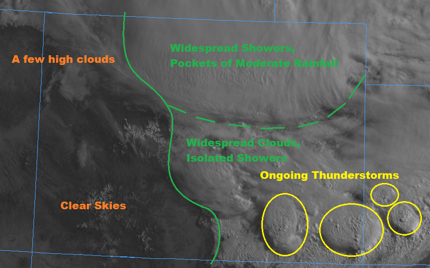
Finally, to the west of the green solid line, you’ll notice that the skies are mostly clear, which will allow for sufficient daytime heating today, setting the stage for afternoon/evening showers/thunderstorms. Low-level moisture is a bit on the low side, and precipitable water is ~0.5” (which is about average for the date) so no flood threat is warranted out west.
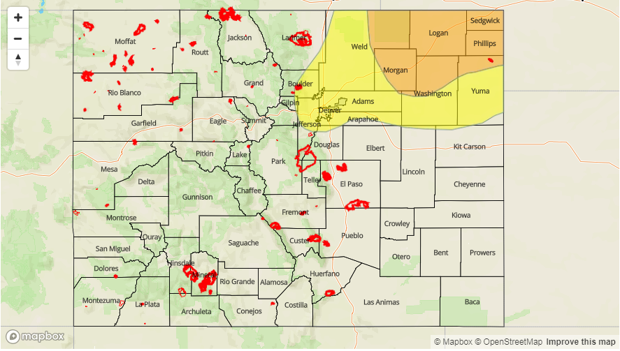
Today’s Flood Threat Map
For more information on today’s flood threat, see the map below (hover over threat areas for more details). For Zone-Specific forecasts, jump below the map.

Zone-Specific Forecasts
Front Range, Urban Corridor, Northeast Plains, and Palmer Ridge:
Cloudy and cool will be the name of the game today, with widespread showers expected across the Northeast Plains, with lesser coverage across the Front Range, Urban Corridor, and Palmer Ridge. A widespread 1-2” of rain fell across the Logan, Morgan, Washington, Phillips, and Sedgwick counties since yesterday afternoon, with a couple pockets upwards of 2.5”. This amount of rain, plus another 1-2” expected through this evening are the reasons behind the issuance of the low-to-moderate flood threat. The main impacts will be street/field flooding, and flooding of low-lying areas. For the Front Range and Urban Corridor, their inclusion in the low threat is due to the potential for afternoon/evening thunderstorms moving overhead from the west.
Northeast Plains: 0.5-1.0 inches/hour
Front Range, Urban Corridor, and Palmer Ridge: 0.4-0.7 inches/hour
Timing for Northeast Plains: Current – Midnight
Timing for Front Range, Urban Corridor, and Palmer Ridge: Current –11 PM
Southeast Plains and Raton Ridge:
After this morning’s activity winds down, there will be a lull until the afternoon with another round of isolated-to-widely scattered thunderstorms are expected to develop, continuing into the evening hours. A couple of the storms will be strong-to-severe, producing hail, strong winds, and periods of moderate rainfall. Rain rates are expected to remain below flash flood thresholds – max rates: 0.7-1.2 inches/hour
Timing: 1 PM – 11 PM
Northern Mountains, Northwest Slope, Central Mountains, Southeast Mountains, San Juan Mountains, Southwest Slope, Grand Valley, and San Luis Valley:
Mostly sunny to start, with increasing clouds as daytime heat and orograophic effects produce bubbling cumulus clouds over the higher terrain. Scattered showers/thunderstorms are expected over the higher terrain, with most eventually drifting over adjacent lower valleys. The best coverage of storms will be north of I-70 where upper-level support is best. Rain rates are expected to stay below flash flood thresholds, with max rain rates as follows:
Northern Mountains, Northwest Slope, Central Mountains, Grand Valley, and Southeast Mountains: 0.4-0.6 inches/hour
Grand Valley, Southwest Slope, San Juan Mountains, and San Luis Valley: 0.1-0.3 inches/hour
Timing: Noon – 10 PM, with a lingering shower or two over the Central and Northern Mountains until Midnight.