Issue Date: 5/20/2018
Issue Time: 12:05 PM
NO flood threat today.
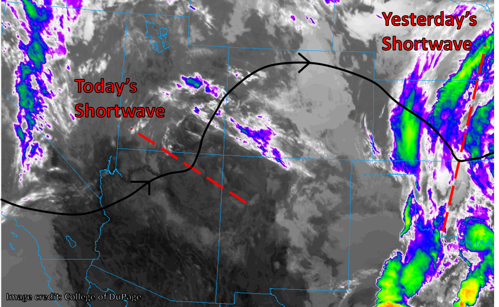
After a very wet last couple of days, the northeastern portions of Colorado should begin to dry out later today, and the mountainous regions of the state should see a round of showers and thunderstorms this evening. The upper-level disturbance that was responsible for some of yesterday’s precipitation is now off to the east (“Yesterday’s Shortwave” in the image below), taking the associated cluster of showers and storms with it. Today’s shortwave is currently situated in northern Arizona and, as indicated by the infrared satellite imagery, is producing little in the way of precipitation or cloud cover. However, as it approaches Colorado from the southwest today, it should tap into the moisture already in place, spawning a fresh round of precipitation.
Upslope flow has persisted this morning in the foothills east of the Continental Divide and the adjacent plains, producing low clouds and drizzle for many in the Urban Corridor. As we progress through the morning, these clouds should lift and burn off, leading to at least some sunshine for many across the state. Meanwhile, showers and storms should start over the higher terrain in the southwestern portion of the state by around noon, with development progressing northward and eastward throughout the day. Rainfall will be light or briefly moderate for most, but favored slopes may see a long-lasting rainfall event today with 24-hour totals approaching 2”. However, given the lower rainfall intensities expected, we do not expect to see a flood threat across Colorado today.
Today’s Flood Threat Map
For more information on today’s flood threat, see the map below (hover over threat areas for more details). For Zone-Specific forecasts, jump below the map.


Zone-Specific Forecasts
Grand Valley, Southwest Slope, San Juan Mountains, Southeast Mountains, Raton Ridge:
Sunny to begin with this morning, but clouds increasing as scattered showers and thunderstorms build during the afternoon. Valleys may remain largely dry, but rain may persist on favored south- and southwest-facing slopes well into the evening.
Rainfall rates: generally 0.05” – 0.20” per hour, may get as high as 0.25” – 0.50” per hour on favored slopes.
Primetime: 11AM to 10PM
Northwest Slope, Northern Mountains, Central Mountains, Front Range:
The sun is out this morning west of the Continental Divide, with low clouds as a result of upslope flow east of the Divide. Expect this first round of cloudiness to lift throughout the morning before clouds build from the south and west with the convection kicked off by the approaching shortwave.
Rainfall rates: generally 0.05” – 0.25” per hour
Primetime: 1PM to 9PM
Southeast Plains, San Luis Valley, Northeast Plains, Urban Corridor, Palmer Ridge:
Low clouds and drizzle to begin with over the western half of the plains this morning, with sunshine for the San Luis Valley and eastern reaches of the plains. A partly sunny and mild day is in the offing for most, with a small chance of a shower or storm rolling off the mountains and onto the adjacent plains. This chance is greatest for the Southeast Plains and Palmer Ridge, as well as southwestern portions of the Denver metro.
Rainfall rates: < 0.10” per hour, up to 0.25” per hour in an isolated thunderstorm
Primetime: 6PM to Midnight