Issue Date: Monday, May 21, 2018
Issue Time: 10:05AM MDT
— Flooding is NOT expected today
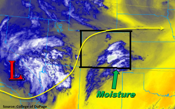
Finally getting to warm up a bit today with more of a ridging pattern after a cool weekend for all. Northeast Colorado had quite the rain-filled weekend with the largest 3-day total (estimated by radar) just over 4 inches in Weld County. Today south/southwest flow returns to the state as the low pressure digs into southern California. A jet forms around the base of the low that will bring upper level diffluence to southern Colorado. Also, marked in the water vapor imagery below are southerly winds. This will pull in moisture from New Mexico, but moisture is expected to be confined to the southern portion of the state. Upper dynamics and this moisture combine to trigger much needed rainfall into this region, which includes the San Luis Valley through this evening. Expect the best coverage over the higher terrains of the Southeast, Central and San Juan Mountains, but thunderstorms are also expected over the Southeast Plains later this afternoon and evening. Dew points are still on the lower end, so expect some gusty winds with storms that form and small hail under the stronger storms to the east. Recent burn scars over the Southeast Mountains may see an isolated shower. However, better moisture remains south, so rain totals should remain under 0.5 inches. Flooding is not expected today. For more details, please see the regional forecasts below.
Today’s Flood Threat Map
For more information on today’s flood threat, see the map below (hover over threat areas for more details). For Zone-Specific forecasts, scroll below the map.
Zone-Specific Forecasts:
Raton Ridge, Southeast Mountains, Southeast Plains, San Luis Valley, San Juan Mountains, Central Mountains, Southwest Slope:
Rain for southern Colorado is expected into this evening. Best coverage will be over the southern, high terrains with rain rates under the stronger storms in the 0.4 – 0.5 inches/hour range. Over the Southeast Plains and Raton Ridge, 1-hour rain rates up to 0.9 inches are possible near the New Mexico border. San Luis Valley 24-hour (isolated) totals could be up to 0.4 inches with local totals in higher terrains nearby up to 1 inch. Flooding is not expected today.
Primetime: 12PM to Midnight
Palmer Ridge, Front Range, Urban Corridor, Northeast Plains:
Isolated showers and thunderstorms are expected over the higher terrains this afternoon with best coverage further south. 1-hour rain rates could be up to 0.3 inches under stronger storms. An isolated thunderstorm could occur over the Palmer Ridge, but more gusty winds are expected than heavy rainfall with 1-hour totals up to 0.4 inches. There is no flood threat today.
Primetime: 2PM to 10 PM
Northwest Slope, Grand Valley, Northern Mountains:
A stray shower with trace amounts of rain could wander into the Grand Valley from the higher terrains this evening. However, with lower moisture over the north, the more likely scenario is partly cloudy skies this afternoon. Temperatures should warm up 5-10F when compared to yesterday.