Issue Date: 5/30/2018
Issue Time: 9:03 AM
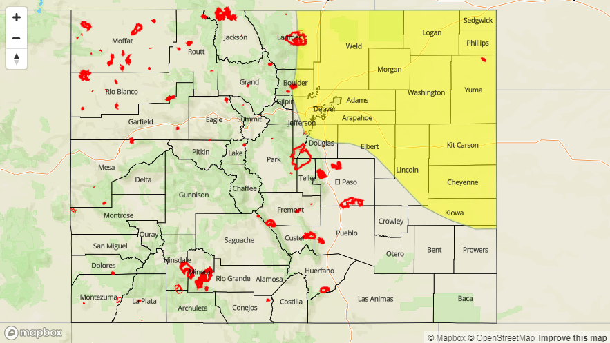
A LOW FLOOD THREAT IS FORECAST TODAY FOR PORTIONS OF THE URBAN CORRIDOR, PALMER RIDGE, NORTHEAST PLAINS, FRONT RANGE, SOUTHEAST MOUNTAINS, SOUTHEAST PLAINS, AND RATON RIDGE.
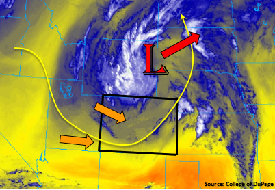
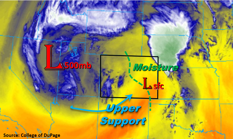
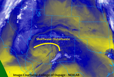
A shortwave disturbance embedded in southwesterly flow aloft will invade Colorado today, triggering scattered showers and thunderstorms across the state. The disturbance shows up distinctly in the water vapor image below, and is accompanied by plenty of mid-level moisture (blue/white colors) to support the activity. For eastern Colorado, the low-level moisture will be sufficient to produce periods of moderate-to-heavy rainfall. Combined with a concern for small hail clogging drainage, and the potential for multiple thunderstorms impacting the same location, a low flood threat is warranted. A few thunderstorms will be on the strong-to-severe side, with the potential to produce large hail (up to 1.5” in diameter), strong winds, and an isolated tornado.
West of the Continental Divide, low-level moisture will be a limiting factor on rainfall, keeping rain rates below flash flood thresholds. The main impacts from storms will be gusty winds, light rainfall, and lightning, with plenty of virga to be noted across the sky. For more information on rain rates and timing, please see the zone-specific forecast discussions below.
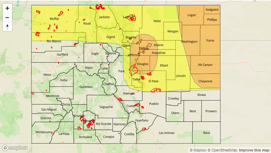
Today’s Flood Threat Map
For more information on today’s flood threat, see the map below (hover over threat areas for more details). For Zone-Specific forecasts, jump below the map.

Zone-Specific Forecasts
Front Range, Urban Corridor, Palmer Ridge, Northeast Plains, Southeast Plains, Southeast Mountains, and Raton Ridge:
Scattered showers and thunderstorms are expected this afternoon and evening, with a few isolated storms continuing until around midnight. Most will be garden-variety, producing periods of light-to-moderate rainfall, gusty winds, and lightning. The atmosphere will support a couple strong-to-severe storms today east of the Mountains, with the potential to produce periods of heavy rain, large hail (up to 1.5 inches in diameter), strong winds, and an isolated tornado. Maximum rain rates are as follows:
Front Range and Southeast Mountains: 0.5-1.0 inches/hour
Northeast Plains, Urban Corridor, Palmer Ridge, and Raton Ridge: 1.0-1.2 inches/hour
Southeast Plains: 1.3-1.6 inches/hour
Timing: 1 PM – 10 PM, with a couple isolated storms rumbling until Midnight-1 AM
Northern Mountains, Northwest Slope, Central Mountains, Grand Valley, San Juan Mountains, San Luis Valley, and Southwest Slope:
Scattered showers/thunderstorms are expected this afternoon and evening, with the best coverage over the higher terrain of west-to-east oriented ranges. “Inverted-V” soundings characterized the environment today (low-level moisture is lacking), so the main impacts from storms today will be light rain, gusty winds, and lightning. Generally speaking, rainfall rates will be in the 0.1-0.2 inches/hour range, with maximum rates around 0.2-0.3 inches/hour.
Timing: 11 AM – 8 PM for the Southwest Slope and San Juan Mountains, Noon – 10 PM for the other regions