Issue Date: Monday, May 28, 2018
Issue Time: 10:40AM MDT
— MODERATE flood threat for portions of the Front Range, Urban Corridor, Northeast Plains and Southeast Plains
— LOW flood threat for the Front Range, Palmer Ridge, Northeast Plains, Urban Corridor, Southeast Plains, Northern Mountains and Northwest Slope
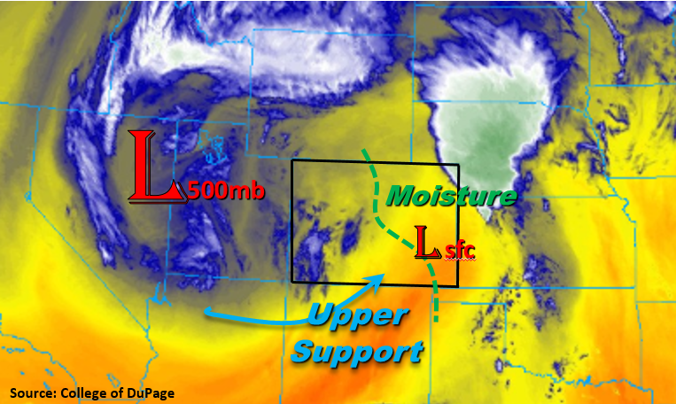
Another round of severe weather and heavy rainfall is expected this afternoon, evening and overnight for the northern portion of the state. Below is the water vapor imagery with several key features for today’s forecast marked. First is the upper low over NV/Utah. Today this will release upper air support in the form of shortwaves and jet streak for more widespread showers and thunderstorm coverage. It will also help maintain showers and thunderstorms overnight throughout the Northern Mountains and northeast corner of the state. Also marked is a surface low, which will help pull in moisture into the state on both to the north and east sides. The moisture axis is drawn in green with higher moisture residing to the east of the line. Dew points will be in the 50s (west) and 60s (east), which will support heavy rainfall. Precipitable Water was measured at 0.75 inches at Denver this morning, and this is expected to increase throughout the day with low-level, moist easterly flow.
Further south, over the southern Southeast Plains, the eastward progression of the dry line throughout the day will limit the heavy rainfall east of Colorado. Low relative humidity and increased winds to the west of the dry line will cause critical fire conditions. A Red Flag Warning is in place through this evening for the San Luis Valley, Southeast Mountains and Raton Ridge. This evening, a MCS sets up over the northeastern plains, with heavy rainfall falling extending south into Cheyenne and Kiowa counties.
This afternoon, upslope flow and instability will help initiate thunderstorms over the Northern Mountains, Front Range and Palmer Ridge. East of the Continental Divide, these storms will begin to move to the northeast into the Urban Corridor and Northeast Plains later in the afternoon. As they move east, they will encounter better instability and shear, which will increase the chances of severe thunderstorms. Threats include large hail (up to 2 inches), strong winds (60-65 mph), a couple tornadoes and heavy rainfall. A Moderate flood threat has been posted for portions of the Urban Corridor due to the potential for street and small stream flooding this afternoon. Max 1-hour rain rates up to 1.2 inches per hour are possible with these thunderstorms.
This evening and overnight another MCS is expected to set up over the Northeast Plains where heavy rainfall occurred yesterday. With already saturated soils, flooding of fields, roads and small streams is likely, so a Moderate flood threat has been issued. 24-hour storm totals could be up to 3.5 inches in this area.
To the west of the Continental Divide, moisture is also forecasted to increase this afternoon with the greatest increases over the Northwest Slope and Northern Mountains. Lifting from the upper wave is expected to initiate more widespread shower and thunderstorm coverage today when compared to yesterday. Convection may persist overnight in the Northern Mountains, but the flood threat will end after sundown. For this afternoon, a Low flood threat has been issued. Threats include road and small stream flooding with the potential for mud flows and debris slides over the steeper terrains.
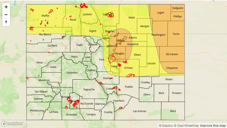
Today’s Flood Threat Map
For more information on today’s flood threat, see the map below. For Zone-Specific forecasts, scroll below the map.

Zone-Specific Forecasts:
Palmer Ridge, Front Range, Urban Corridor, Northeast Plains:
Instability and upper dynamics will support severe thunderstorms and heavy rainfall this afternoon into the night. 1-hour rain rates up to 1.2 inches are possible over the Urban Corridor, so a Moderate flood threat has been issued. Further east, 1-hour rain rates up to 2.2 inches are possible due to high low-level moisture today. Isolated 24 hour totals over the far eastern plains will exceed 3.5 inches due to thunderstorms continuing through the night. Due to heavy rainfall last night, a Moderate flood threat has been issued. Threats include street, field and small stream flooding. East of the Front Range, severe weather is expected this afternoon with large hail (up to 2 inches), strong winds (60-65 mph) and, possibly, a couple of tornadoes.
Primetime: 1PM – 4AM
Southeast Plains, Southeast Mountains, Raton Ridge:
A few thunderstorms may form over the Southeast Mountains this afternoon. Moisture this far south will be restricted, so 1-hour rain rates will be limited to 0.25 inches/hour. Low relative humidity and increasing winds will cause critical fire danger to the west. Please use caution with any sort of spark through this evening. A Red Flag Warning is in place. Overnight rainfall could extend south into Kiowa County where 24-hour totals up to 2.0 inches are possible.
Primetime: 2PM – 8PM
San Luis Valley, San Juan Mountains, Central Mountains, Southwest Slope, Northwest Slope, Grand Valley, Northern Mountains:
Increases in moisture and upper level support will help trigger numerous thunderstorms over the Northwest Slope and Central Mountains this afternoon. Max 1-hour rain rates up to 1 inch are possible, so a Low flood threat has been issued. Threats include small stream and street flooding with the possibility of mud flows and debris slides over the steeper terrain of the Northern Mountains. There may be a few linger showers overnight, but the flood threat should end around sundown.
Primetime: 1PM – 8PM