Issue Date: 5/27/2018
Issue Time: 8:35 AM
A LOW FLOOD THREAT IS FORECAST TODAY FOR PORTIONS OF THE NORTHEAST PLAINS, SOUTHEAST PLAINS, URBAN CORRIDOR, FRONT RANGE, AND PALMER RIDGE.
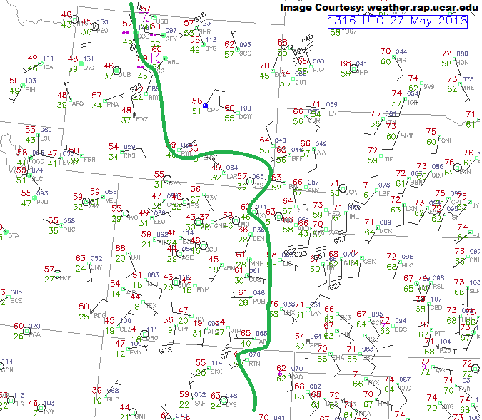
Today’s forecast across Colorado will be defined by those with access to moisture and those without access to moisture. In the surface plot shown below, a thick green line has been drawn to denote the location of the 45°F dewpoint contour. To the right of the line, ample moisture is already in place to fuel a fairly active strong-to-severe thunderstorm day. Strong instability and “good enough” shear will coincide with this low-level moisture, which will promote quickly strengthening thunderstorms capable of producing large hail (up to 1.5” diameter), strong winds (up to 70-80 mph), an isolated tornado or two, and periods of heavy rainfall. Precipitable water values will push to near, or exceed, 1 inch across the far eastern plains by this evening, so that makes our ears perk up with regards to flash flooding concerns. Storm motions should keep storms moving quickly enough to avoid flash flooding, but the possibility of training thunderstorms is enough to warrant a low flood threat. Portions of the Front Range, Urban Corridor, and Palmer Ridge are also included in the low flood threat due to easterly flow likely pushing the 45°F dewpoint line back into the area during the afternoon/evening hours, providing enough moisture for a quick 0.5”/30 min rainfall – this is enough to cause street flooding in urban areas.
To the left of the green line (not including the Urban Corridor/Front Range for reasons described above), mainly dry conditions will win out. The exception to this rule will be across the higher terrain of the Northwest Slope and Northern Mountains where enough moisture will sneak into the state from the north to work with orographic support and result in isolated showers/weak thunderstorms.
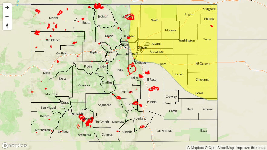
Today’s Flood Threat Map
For more information on today’s flood threat, see the map below (hover over threat areas for more details). For Zone-Specific forecasts, jump below the map.

Zone-Specific Forecasts
Front Range, Urban Corridor, Northeast Plains, Southeast Plains, Palmer Ridge, and Raton Ridge:
Strong Isolated-to-scattered thunderstorms will rumble this afternoon/evening, with a few reaching severe thresholds. The main threats will be large hail (up to 1.5” diameter), strong winds (up to 70-80 mph), and periods of heavy rainfall, with the potential for an isolated tornado or two. The Raton Ridge will remain mostly dry, but an isolated thunderstorm or two will result in gusty winds, dangerous lightning, and a brief period of light rainfall.
Training storms over the Northeast Plains and quick bursts of heavy rain over urban areas and steep(er) terrain of the Front Range are the driving forces behind today’s low flood threat. Maximum rain rates are as follows:
Front Range, Urban Corridor, and Palmer Ridge: 0.4-0.6 inches/30 minutes
Northeast Plains and Southeast Plains: 1.5-2.0 inches/hour
Raton Ridge: 0.15-0.3 inches/hour
Timing: Noon – 10 PM, with an isolated storm or two rumbling until midnight
Northwest Slope, Northern Mountains, Central Mountains, Grand Valley, Southwest Slope, San Juan Mountains, Southeast Mountains, San Luis Valley:
Dry and warm, though temperatures will be a few degrees cooler than yesterday. The exception to the dry rule will be over the higher terrain of the Northwest Slope and Northern Mountains where enough low-level moisture will be in place to fuel orographically-forced showers/weak thunderstorms. Rain rates will be low, with maximum rates of 0.15-0.25 inches/hour
Timing: Noon – Midnight