FTB 06-03-2018: Compact Upper Wave to Deliver Rain to Drought-Stricken Southern CO

Issue Date: 6/3/2018
Issue Time: 10:15 AM

NO FLOOD THREAT IS FORECAST TODAY.

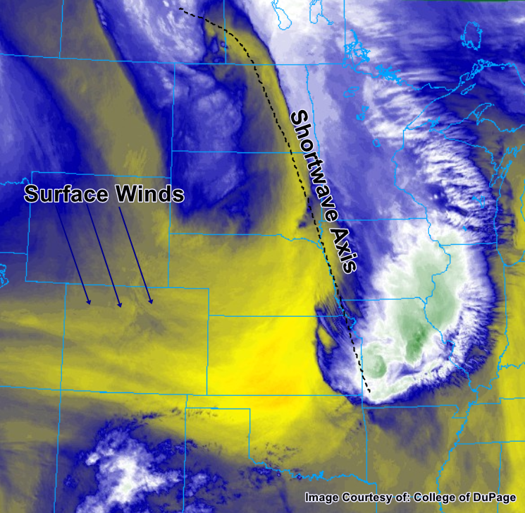
Following several days of largely dry and hot weather across Colorado, a compact and fast-moving but potent upper-level low is currently approaching the state from the southwest. The low has begun to draw plentiful moisture northward into the southern half of the state, as evidenced by this morning’s GOES-16 water vapor imagery (see figure below). As the low moves rapidly east-northeastward, this envelope of moisture will expand, allowing for widespread showers and some thunderstorms across most of the southern half of the state. In addition, the moisture may creep far enough northward to produce some scattered thunderstorms across northeastern portions of the state. At this time, chances of receiving notable precipitation outside the mountains appear remote.

With the abundance of moisture expected, there is some risk of brief heavy rainfall across portions of the state, particularly across the southwest. However, with the dry conditions and very low snowpack that have prevailed there of late, excessive runoff is not anticipated to be an issue. Instead, the moisture will provide welcome relief for many. As the low continues to track off to the east-northeast, the precipitation threat will diminish from southwest to northeast. Precipitation will come to an end before sunset across the southwest corner, whereas rain in the central portion of the state may linger for several more hours. There is no flood threat today.

Today’s Flood Threat Map

For more information on today’s flood threat, see the map below (hover over threat areas for more details). For Zone-Specific forecasts, jump below the map.

Flood Threat Legend

Zone-Specific Forecasts

Grand Valley, Southwest Slope, San Juan Mountains, Central Mountains, Southeast Mountains, Northern Mountains, Front Range:

Mostly cloudy conditions with a few showers along the state’s southern border are already present this morning, with both clouds and precipitation expected to increase in coverage through early- to mid-afternoon. Generally, precipitation intensities should be in the 0.05” to 0.20” per hour range, but isolated spots may briefly approach 0.5” per hour. The highest rainfall totals may reach around 1.0-1.5” and will be over elevated terrain on the west/southwest facing slopes.

Primetime: 10AM to 9PM

Northwest Slope, San Luis Valley:

 Just isolated light rain is expected for the state’s two high arid regions, with precipitation largely confined to the higher terrain on the fringes of these regions. Rain that occurs will be light, with rainfall rates less than 0.1” per hour and daily rainfall totals of less than 0.25”. Cloud cover will likely be present for much of the day, keeping temperatures down.

Primetime: now through 9PM

Urban Corridor, Northeast Plains, Palmer Ridge, Southeast Plains, Raton Ridge:

Widely scattered thunderstorms are possible but unlikely today for most of the area east of the mountains, with locations nearest the mountains (i.e., farther west) the most likely to experience any measurable precipitation. Rainfall rates will be light, as dry surface air will evaporate much of what falls. Nonetheless, 1-hour rain rates up to 0.25” per hour are possible.

Primetime: 3PM to 9PM

FTB 06-02-2018: Shifting Winds and Cooler Temperatures

Issue Date: 6/2/2018
Issue Time: 9:30 AM

NO FLOOD THREAT IS FORECAST TODAY.

The trough of low pressure that passed just to the north of Colorado yesterday has swiftly moved off to the east, and in its wake has shifted the general wind direction from the south/southwest to more northerly with the passage of a cold front. These north winds mean that daytime high temperatures will be up to 10 degrees cooler across much of Colorado. Most importantly, for the southern part of the state, there is a substantial decrease in the risk of dangerous fire conditions, due in part to the wind shift as well as higher relative humidity and reduced wind gusts.

Aloft, winds remain westerly, which will bring in drier air to the upper atmosphere above Colorado. This, in conjunction with broad subsidence, will make it exceptionally difficult for any afternoon thunderstorms or showers to develop across the state. Expect a few cumulus over the mountains, although it should be a rain free and clear day across Colorado. So, if you can, get out and enjoy the sun and relatively cool conditions today before the chance of rainfall increases tomorrow.

Today’s Flood Threat Map

For more information on today’s flood threat, see the map below (hover over threat areas for more details). For Zone-Specific forecasts, jump below the map.

Flood Threat Legend

Zone-Specific Forecasts

Front Range, Urban Corridor, Palmer Ridge, Northeast Plains, Southeast Plains, Raton Ridge, Central Mountains, Southeast Mountains, and San Luis Valley:

Should be a clear day with temperatures much closer to average for this time of year. Temperatures will be up to 10F cooler than yesterday with the passage of the cold front. The few cumulus that are able to form over the mountains will provide no to trace amounts of rainfall. Expect a slight increase in cloud cover this afternoon.

Northern Mountains, Northwest Slope, Grand Valley, San Juan Mountains, and Southwest Slope:

Plenty of sunshine, with cooler temperatures compared to the latter part of the week. Critical fire danger has been lifted; however, the dry ground is still susceptible to burning. Please use caution with open flames. Overnight and into tomorrow morning, cloud cover and showers will begin to increase ahead of the disturbance on Sunday. They should be confined to the southwest corner of the state. Flooding is not expected today.

Timing: 4 AM to 11 AM

FTB 06-01-2018: Hot and Dry with Critical Fire Weather Conditions

Issue Date: 6/1/2018
Issue Time: 6:30 AM

NO FLOOD THREAT IS FORECAST TODAY.

A low pressure trough passing through the region typically means unsettled weather for Colorado, but such is not the case today. Instead, we will be influenced by the base of the trough, reaping all of the dry, southwesterly-turning-westerly flow and none of the support for thunderstorm development. The result will be a dry and warm day statewide with critical fire danger conditions across much of the High Country and adjacent lower elevations. Steep lapse rates will allow for excellent mixing down of winds aloft, with 45-55 mph gusts at ridge top and 30-40 mph across adjacent lower elevations. Be sure to check in with your local National Weather Service for any information regarding the Red Flag Warnings that are in effect.

One area to watch for a few isolated thunderstorms will be along the CO/WY/NE border in extreme northern Colorado during the afternoon/evening. Near enough to the trough and with access to weak instability and/or assisted by orographic support, there will be enough to trigger a couple isolated, high-based thunderstorms. Very little, if any, rainfall is expected, and the main impacts will be gusty winds, lightning, and streaks of virga painting the sky.

Today’s Flood Threat Map

For more information on today’s flood threat, see the map below (hover over threat areas for more details). For Zone-Specific forecasts, jump below the map.

Flood Threat Legend

Zone-Specific Forecasts

Urban Corridor, Palmer Ridge, Northeast Plains, Southeast Plains, and Raton Ridge:

Hot and dry with gusty winds are the name of the weather game today, with Red Flag Warnings issued for portions of the Southeast Plains, Urban Corridor, Palmer Ridge, and Raton Ridge. Far northern portions of the Urban Corridor and Northeast Plains will see an isolated high-based storm or two during the afternoon/evening hours, but very little rainfall is expected. Maximum rain rates will be 0.05-0.15 inches/hour.

Timing: 3 PM – 11 PM

Northern Mountains, Northwest Slope, Front Range, Central Mountains, Grand Valley, San Juan Mountains, Southeast Mountains, San Luis Valley, and Southwest Slope:

Mostly sunny, dry, and warm conditions are expected, with critical fire danger across much of the area (Red Flag Warnings are in place – check with your local NWS office). A few isolated, high-based thunderstorms are expected near the CO/WY border across the Northwest Slope, Northern Mountain, and Front Range regions. Very little rainfall is expected from any activity that may occur; instead, gusty winds and virga will be about all the atmosphere can muster. Rain rates will remain below 0.1 inches/hour.

Timing: NOON – 9 PM

FTB 05-31-2018: High Pressure Ridge and Dry Air Invade the State

Issue Date: 5/31/2018
Issue Time: 8:20 AM

NO FLOOD THREAT IS FORECAST TODAY.

High pressure ridging aloft and dry, southwesterly flow aloft will suppress the atmosphere today, drying out the state and allowing temperatures to warm a few degrees as compared to yesterday. There is enough residual moisture for the development of scattered fair-weather cumulus clouds over and adjacent to the higher terrain, but that will be about all that Mother Nature can muster today.

One exception to the quiet rule will be over the Northern Mountains, the northern half of the Central Mountains, and the Front Range north of the Pike National Forest. In those regions, orographic effects and enough residual moisture will be able to overcome the weak cap to produce isolated, high-based showers/thunderstorms. It will remain too dry beneath the clouds for measurable rainfall; gusty winds and virga will be the main impacts, with only a brief sprinkle noted.

Today’s Flood Threat Map

For more information on today’s flood threat, see the map below (hover over threat areas for more details). For Zone-Specific forecasts, jump below the map.

Flood Threat Legend

Zone-Specific Forecasts

Urban Corridor, Northeast Plains, Southeast Plains, Palmer Ridge, and Raton Ridge:

Hot and dry with plenty of sunshine to go around. A few afternoon/evening fair weather cumulus clouds will be noted near the higher terrain of the Front Range, providing small pockets of shade, a few streaks of virga, and nothing more. The Urban Corridor and far western portions of the Northeast Plains, during the late afternoon/evening hours, may see an isolated shower/high-based thunderstorm as a result of mountain activity. The potential for this remains very low (10%), but it is possible so it deserves a mention. Rain rates from any activity will be less than 0.1 inches/hour.

Northern Mountains, Front Range, and Central Mountains:

Mostly sunny, warm, and dry will be the main weather result today as the atmosphere is lacking moisture and upper-level support to produce anything of substance. An isolated afternoon/evening high-based showers/thunderstorm triggered by a combination of orographic effects and daytime heating cannot be ruled out, but any such activity will result in more wind than rain. Maximum rain rates will be 0.05-0.1 inches/hour.

Timing: 3 PM – 9 PM

Northwest Slope, Central Mountains, Grand Valley, Southwest Slope, San Juan Mountains, Southeast Mountains, San Luis Valley:

Sunny, warm, and dry will be the name of the weather game today, as dry air and upper-level ridging conspire to create a “severe clear” day. Gusty winds, low relative humidity, and dry fuels mean that fire danger is elevated today. Red Flag Warnings have been issued for much of the area, so be sure to check with your local NWS office for more information.