Issue Date: 7/5/2018
Issue Time: 8:15 AM
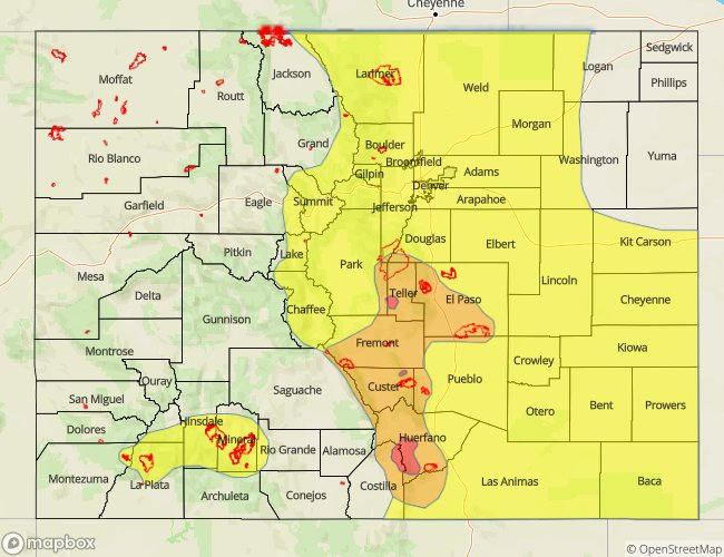
A HIGH FLOOD THREAT IS FORECAST TODAY FOR PORTIONS OF THE FRONT RANGE AND SOUTHEAST MOUNTAINS, NAMELY FOR THE SPRING FIRE, CHATEAU FIRE, AND ADOBE FIRE BURN AREAS.
A MODERATE FLOOD THREAT IS FORECAST TODAY FOR PORTIONS OF THE FRONT RANGE, URBAN CORRIDOR, PALMER RIDGE, SOUTHEAST MOUNTAINS, RATON RIDGE, AND SOUTHEAST PLAINS.
A LOW FLOOD THREAT IS FORECAST FOR PORTIONS OF THE SOUTHEAST PLAINS, RATON RIDGE, SOUTHEAST MOUNTAINS, URBAN CORRIDOR, PALMER RIDGE, NORTHEAST PLAINS, FRONT RANGE, CENTRAL MOUNTAINS, AND NORTHERN MOUNTAINS.
A LOW FLOOD THREAT IS FORECAST FOR PORTIONS OF THE SOUTHWEST SLOPE AND SAN JUAN MOUNTAINS, NAMELY THE 416 FIRE AND BURRO FIRE BURN AREAS, AS WELL AS THE WEST FORK COMPLEX BURN AREAS.
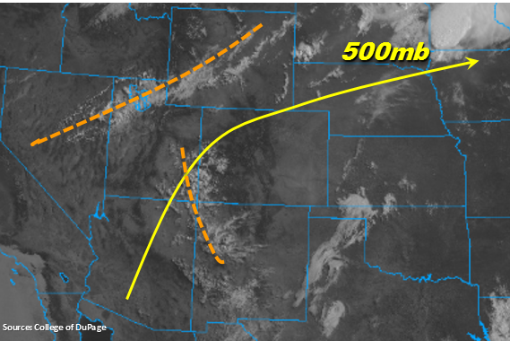
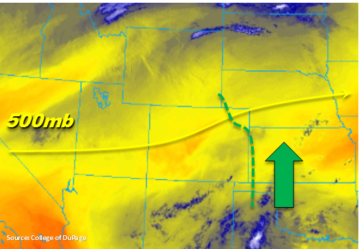
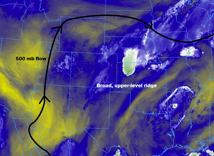
The broad upper-level ridge over the central United States will continue to retrograde west through the period, becoming centered over Colorado during the afternoon/evening. This will place Colorado under weak flow aloft, which will set the stage for slow-moving showers/thunderstorms. At the same time, deeper moisture is setting up along/east of the Continental Divide due to the combination of mid-level moisture from the east/southeast and easterly flow from the Great Plains. In combination, these two factors will allow for showers/thunderstorms with efficient rainfall production to have increased residence time over a location, enhancing the flooding threat.
Overall, the main factor behind this period’s high/moderate flood threat is the number of recent burn scars potentially being impacted by slow-moving showers and thunderstorms today/tonight. For new burn scars, it will likely take no more than 0.25-0.4 inches/hour rain rates to cause flash flooding, debris slides, and mud flows, and for older burn scars such as the Hayden Pass and Junkins, it will only take slightly higher rain rates. In addition to the area burn scars and steep terrain, the Colorado Springs area has been included in the Moderate Flood Threat due to the heavy rain they experienced last night. Any excessive rainfall today will have enhanced runoff due to the saturated soils in the area.
The reason the 416 Fire and Burro Fire are NOT included in the moderate flood threat, but rather are under a low flood threat, is due to a relative lack of good moisture in the low-levels over the area. Evaporation as precipitation falls will play a role in reducing rain rates over the area, but it only takes one slow-moving storm, or a second storm over an area that became saturated due to another storm’s outflow to mitigate this effect. Thus, they deserve a watchful eye today.
For more information on timing and rain rates, please see the zone-specific forecast discussions below.
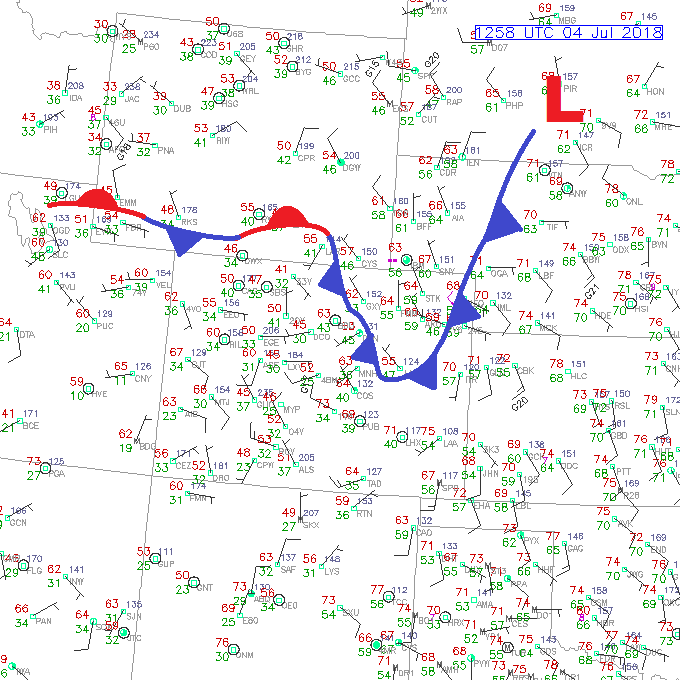
Today’s Flood Threat Map
For more information on today’s flood threat, see the map below (hover over threat areas for more details). For Zone-Specific forecasts, jump below the map.
Zone-Specific Forecasts
Front Range, Urban Corridor, Palmer Ridge, Northeast Plains, Southeast Plains, Southeast Mountains, and Raton Ridge:
Scattered-to-widespread showers/thunderstorms expected today/tonight, with the bulk of the activity occurring over the Front Range, Urban Corridor, Palmer Ridge, Southeast Mountains, Raton Ridge, and western portions of the Northeast Plains and Southeast Plains. As the evening turns to nighttime, the main area of precipitation will shift eastward towards the CO/KS/NE border. Maximum rain rates are as follows:
Front Range: 0.8-1.2 inches/hour
Urban Corridor and Palmer Ridge: 1.2-1.8 inches/hour
Northeast Plains and Southeast Plains: 1.5-2.0 inches/hour
Raton Ridge: 1.2-1.8 inches/hour
Southeast Mountains: 0.9-1.3 inches/hour
Timing: 11 AM – 11 PM over the Front Range and Southeast Mountains, 2 PM – Midnight for the Urban Corridor, and 2 PM – 1 AM for the Southeast Plains, Northeast Plains, and Raton Ridge (with a couple lingering showers/thunderstorms into the early morning hours)
Northern Mountains, Northwest Slope, Central Mountains, Grand Valley, San Juan Mountains, San Luis Valley, and Southwest Slope:
Scattered showers/thunderstorms are on tap today/tonight across the area, with the bulk of the activity favoring the higher terrain of the Southwest Slope, San Juan Mountains, Central Mountains, and Northern Mountains. More isolated activity is expected over the higher terrain elsewhere.
Storms will drift over adjacent lower elevations with time. Most showers/thunderstorms will be of the garden-variety, producing light rain and gusty winds, but a stronger storm or two will be capable of producing brief moderate rainfall, especially over the Southwest Slope, San Juan Mountains, Northern Mountains, and Central Mountains, where moisture and support will be best. Maximum rain rates are as follows:
Northern Mountains and Central Mountains: 0.7-1.1 inches/hour
Northwest Slope and Grand Valley: 0.2-0.4 inches/hour
Southwest Slope, San Juan Mountains, and San Luis Valley: 0.5-0.8 inches/hour
Timing: 11 AM – 9 PM, with isolated lingering showers/thunderstorms into the early morning hours south of I-70.