Issue Date: Monday, July 2, 2018
Issue Time: 09:50AM MDT
— Flooding is NOT expected today
The ridge begins to build to the east of Colorado today, which will give westerly flow aloft this morning more of a southwesterly component this afternoon. This will pull in dry, warm air from the desert southwest, which will help high temperatures to climb a few more degrees today. This will also help to dry out the atmosphere and limit rainfall totals over the elevated terrain this afternoon with storms that develop under the diurnal upslope flow process. Without any upper level support, expecting only isolated showers over the Southwest, San Juan and Southern Front Range Mountains with plenty of virga and some gusty winds.
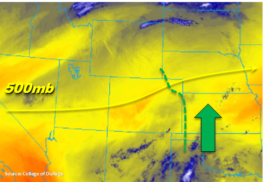
Later this afternoon, a weak shower or two are forecast move off the mountains into the Urban Corridor/Northeast Plains. A lee trough over the eastern plains is expected to pull in moisture-rich air with southerly flow on its north and east sides. Thus, as storms move northeast/east into the Northeast Plains, the higher low-level moisture (marked with the green below) will increase rainfall totals. Another line of convergence (dry line) will promote thunderstorm growth over the Southeast Plains. The highest surface dew points are expected to be east of Colorado, so there should be plenty of strong wind gusts associated with these thunderstorms. As all the thunderstorms move towards the eastern border today, their chance for becoming severe increases. The main threats will be severe hail and wind gusts greater than 60 mph. Rainfall rates are expected to stay under flood threat criteria, so there is no flood threat today.
Today’s Flood Threat Map
For more information on today’s flood threat, see the map below. For Zone-Specific forecasts, scroll below the map.
Zone-Specific Forecasts:
Front Range, Urban Corridor, Palmer Ridge, San Luis Valley, Southeast Mountains, Raton Ridge, San Juan Mountains:
Temperatures should be on the increase a few ticks today with southwesterly flow aloft. Expect isolated, diurnal storms to fire over the higher terrains this afternoon under upslope flow. Without too much low-level moisture, expecting more virga and gusty winds than measureable rainfall. A few of these storms will move into the Urban Corridor and Northeast Plains this afternoon. Max 1-hour rain rates in the adjacent plains could reach 0.5 inches over the eastern Urban Corridor. Flooding is not expected today.
Primetime: 1PM to 9 PM
Southeast Plains, Northeast Plains:
Southerly flow will allow low-level moisture to be a bit higher over the eastern plains this afternoon. Storms that are able to make it off the mountains into the Northeast Plains could have max 1-hour rain rates up to 1.25 inches. Over the Southeast Plains, larger spread between the dew point and temperature will promote gusty winds. Localized, max 1-hour rain rates up to 1.4 inches/hour are possible. Flooding is not expected today.
Primetime: 3PM to Midnight
Northern Mountains, Southwest Slope, Grand Valley, Central Mountains, Northwest Slope:
The arid southwest flow will continue to dry out the atmosphere today, so rain is not forecast. Expecting some increasing cloud cover over the higher terrains this afternoon as well as over the Northwest Slope. Plentiful sunshine should allow high temperatures to be a couple degrees warmer when compared to yesterday.