Issue Date: Tuesday, July 3, 2018
Issue Time: 09:10AM MDT
— Flooding is NOT expected today
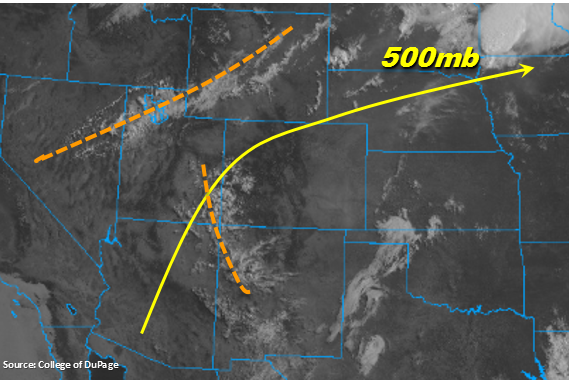
Visible satellite imagery below shows a couple upper atmospheric disturbances marked in orange. The first one over Utah is associated with the trough positioned over the Pacific Northwest. This local area of lift should stay north and west of the state due to the 500mb ridge building west. The second disturbance over southwest Colorado will help bring increased cloud cover and maybe some light rain to the San Juan Mountains early this afternoon. However, soundings in the area shows inverted-V profiles, so the more likely scenario is breezy conditions and only trace amounts of rainfall. This small increase in moisture will keep the Red Flag Warning further north where the tightening gradient of the Pacific Northwest trough will mix down some windy conditions at the surface at the lower elevations.
The diurnal flow pattern will initiate thunderstorms over the higher terrains and Palmer Ridge by this afternoon. Low-level atmospheric moisture is still limited, so not expecting much rain with these storms. There is decent mid-level moisture in Denver’s sounding this morning, so forecasting some cumulus that should provide some decent shade to the heat this afternoon. As the showers move to the northeast/east, they will encounter some better moisture (for more rainfall) over the northeast corner of the state where 50F dew points are able to hold on. Dew points will be much lower over the Southeast Plains as the low-level moisture gets mixed out to the east, so not expecting as much rainfall here. Light showers and weak thunderstorms may initiate after sundown as moisture returns westward to the eastern plains and multiple outflow boundaries provide lift. Flooding is not forecast today.
Today’s Flood Threat Map
For more information on today’s flood threat, see the map below. For Zone-Specific forecasts, scroll below the map.

Zone-Specific Forecasts:
Front Range, Urban Corridor, Palmer Ridge, San Luis Valley, Southeast Mountains, Raton Ridge, Southeast Plains, Northeast Plains:
High temperatures should be close to yesterday with more breezy conditions over the Southeast Mountains and adjacent plains. Without too much low-level moisture to the west, expecting more virga and cloud cover rather than rainfall. Max 1-hour rain rates should be under 0.1 inches. Over the Northeast Plains, higher dew points will help produce rain rates up to 0.9 inches/hour, while the Southeast Plains should only see rain rates up to 0.4 inches/hour. The HRRR is showing lots of smoke over these regions, so hazy conditions will continue with all the ongoing fires in the state. Flooding is not expected today.
Primetime: 1PM to 1AM
Northern Mountains, Southwest Slope, Grand Valley, Central Mountains, Northwest Slope, San Juan Mountains:
Increased cloud cover for the southwest corner of the state thanks to a disturbance traveling north from NM/AZ. This increase in moisture is enough to lift the Red Flag Warning over the higher terrains today west of the Divide. Not expecting too much rainfall, but with this disturbance, localized totals up to 0.15 inches over the San Juan Mountains are possible. However, inverted-V atmospheric profiles will more so produce gusty winds with these storms than measurable rainfall. Over the northwest corner of the state at the lower elevations, increased surface winds and dry, warm air will continue to keep this area under a Red Flag Warning. Flooding is not expected today, but smoky conditions will continue over southwest Colorado.
Primetime: 11:30AM to 9PM