FTB 08-22-2018: Monsoon Moisture Surge Continues

Issue Date: Wednesday, August 22nd, 2018
Issue Time: 09:25AM MDT

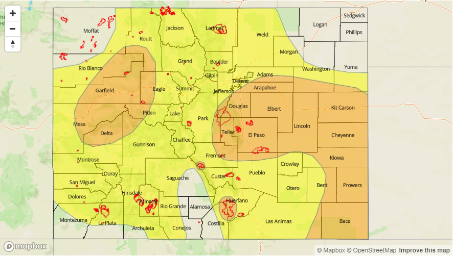
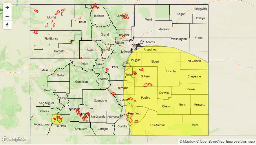
— A LOW flood threat has been issued for portions of the Front Range, Urban Corridor, Palmer Ridge, Southeast Plains, Southeast Mountains and Raton Ridge

— A LOW flood threat has been issued for the 416/Burro and Spring Creek burn areas

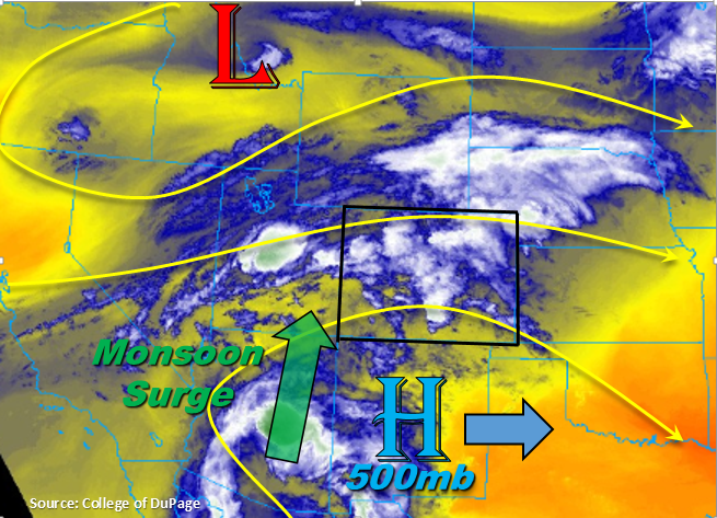
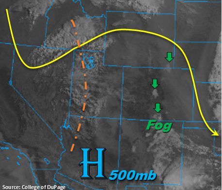
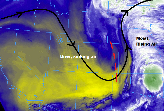
This morning is a reminder that fall is just around the corner. A nice cool start to Wednesday morning after near statewide rainfall yesterday. Temperatures are currently in the upper 50Fs to low 60Fs over the lower terrains with some snow being reported over the higher peaks. The monsoon moisture surge is still well under way with the 500mb high positioned over eastern TX. The trough to northwest will start its eastward migration today, which should provide a little extra lift to keep light to moderate showers going over northern Colorado throughout the day. By early afternoon, some breaks in the clouds over southeast Colorado will allow a bit of instability to build. This is expected to lead to some thunderstorm development over this area, whereas elsewhere, convection will be more moderate and stratiform in nature.

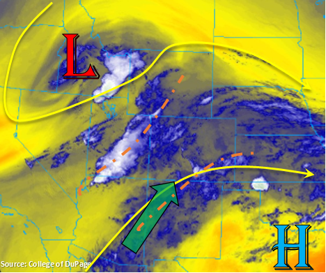
Soundings this morning show PW was over an inch for both Grand Junction and Denver. This is very high for this time of year, but it will help provide another round of some much needed rainfall to the state. This afternoon, dew points are forecast to remain in the low 60Fs over the Southeast Plains. This means that the isolated thunderstorms that form over this area will have the potential to produce some heavy rainfall again. Extra mid-level energy will also continue to rotate clockwise around the high, which will provide some extra lift. Decent storm motion should keep in check widespread flooding, but storms that track over the same areas as the last 24-hours could produce increased runoff. A Low flood threat has been issued with the mains threat being field ponding, flooding of low-lying roads and local stream flooding. While rainfall over the San Juan Mountains is not expected to be overly convective today, max 1-hour rain rates up to 0.8 inches, due to the high low-level moisture, could be problematic for the 416 and Burro burn scars. A Low flood threat has been issued for these burn scars as well.

Today’s Flood Threat Map

For more information on today’s flood threat, see the map below. For Zone-Specific forecasts, scroll below the map.

 
Flood Threat Legend


Zone-Specific Forecasts:

Grand Valley, Central Mountains, San Juan Mountains, San Luis Valley, Southwest Slope, Northern Mountains, Northwest Slope, Northeast Plains:

Showers are expected to pick up in intensity throughout the day, though rain rates are expected to be light to moderate. This will bring some beneficial rain to all the regions once again. Burn scars will continue be susceptible to flash flooding today as rain rates greater than 0.5 inches/hour are possible, so a Low flood threat has been issued for the 416/Burro burn area. Max 1-hr rain rates up to 0.8 inches are possible though most 1-hour totals will be in the 0.25-0.5 inch range under the stronger cores. Threats for storms that track over burn scars include mud flows, debris slides and local stream flooding.

Primetime: 12PM – 8PM

Southeast Plains, Raton Ridge, Southeast Mountains, Front Range, Palmer Ridge, Urban Corridor:

Thunderstorm development is likely again over the Southeast Plains today as well as over the Palmer Ridge. The more severe threat will be over the far Southeast Plains, though storms are expected to meet only minimal severe threat criteria. The convection should be somewhat isolated in nature as there will be limited instability over the adjacent plains where there are breaks in the clouds by early afternoon. The exact location of the cloud breaks are difficult to forecast, thus all areas in the adjacent plains have been included in the Low threat. Threats include heavy rainfall, hail, strong winds and local stream flooding due to increased runoff. Unlike yesterday, storm activity should decrease a couple of hours after sundown as the low-level jet sets up east of Colorado. It will still be possible for a few light showers over the Southeast Plains overnight. Max 1-hr rain rates up to 1.1 inch (west) and 1.75 inches (east) are possible today. A Low flood threat has been issued that includes the Spring Creek burn scar.

Primetime: 1:30PM – 10PM

FTB 08-21-2018: Heavy Rainfall Expected with Monsoon Moisture Surge

Issue Date: Tuesday, August 21st, 2018
Issue Time: 09:25AM MDT

— A MODERATE flood threat has been issued for the Lake Christine, Hayden Pass and Spring Creek burn areas

— A MODERATE flood threat has been issued for portions of the Northwest Slope, Northern Mountains, Central Mountains, Grand Valley, Palmer Ridge, Southeast Plains, Front Range and Urban Corridor

— A LOW flood threat has been issued for all zones excluding the San Luis Valley

Lots of cloud cover over the state to start this morning along with some moderate to light showers over the Central Mountains and far Northeast Plains. Haze is still being reported over the Southeast Plains with some fog near Trinidad. Between the shifting upper-level winds and rainfall today, we should get a break from what feels like the never ending haze. The early morning rainfall over the mountains also indicates that moisture has returned to the area. PW values at Grand Junction and Denver were at 0.88 and 0.85 inches, respectively. Both are expected to increase throughout the day with the monsoon moisture plume surging north. With the 500mb high shifting into Texas, dew points (Tds) this afternoon will likely reach the mid-to-upper 50Fs along the Urban Corridor with Tds just over 60F in the Southeast Plains as southeasterly surface flow resumes. The ongoing showers over western Colorado will help moisten the lower levels, so rainfall totals can be expected to increase throughout the day.

The approaching shortwaves during the course of the day will help create widespread showers both east and west of the Continental Divide by increasing lift. More than one round of storms are expected over Western CO today, and some trailing storms will be likely over eastern CO as well as clusters of thunderstorms this evening over the plains. An upper level jet will also move into western Colorado, so this should keep storm movement to the west at a fairly decent speed. However, with the monsoon surge, heavy local rainfall will still be likely. Showers are also expected overnight thanks to jet, which may bring localized 24-hour totals exceeding 2 inches over the Central Mountains and Southeast Plains. A Moderate and Low flood threat have been issued.

Some more isolated, severe storms are possible over the Southeast Plains this afternoon. Moderate shear and high instability would support damaging winds, large hail and heavy rainfall. The severe threat should end a couple hours after sundown, but the cluster of storms should is expected to produce rainfall into the early morning. Today, rainfall rates will be potentially problematic for recent burn scars. A Moderate threat has been issued for the Lake Christine, Hayden Pass and Spring Creek burn scars due to higher confidence rainfall rates in the area will exceed 0.5 inches/hour, which has caused flooding issues in the past. A Low flood threat for the other recent burn scars should suffice. Threats today over the higher terrains and burn scars include mud flows, debris slides, arroyo flooding, local stream flooding and flooding of low lying roadways. Over flatter terrains and urban areas, field ponding and street flooding are possible.

Today’s Flood Threat Map

For more information on today’s flood threat, see the map below. For Zone-Specific forecasts, scroll below the map.

Flood Threat Legend


Zone-Specific Forecasts:

Grand Valley, Central Mountains, San Juan Mountains, San Luis Valley, Southwest Slope, Northern Mountains, Northwest Slope:

A couple rounds of showers and thunderstorms expected over western CO today. The lower valleys are also expected to get on the rainfall, which is very much needed. A jet will move into western CO, which will help support showers and weak thunderstorms overnight into tomorrow morning over the Central Mountains. Localized totals over the Central Mountains around 2 inches by tomorrow morning are possible. Burn scars, especially Lake Christine, will be susceptible to flash flooding today and overnight. Max 1-hr rain rates up to 1.2 inches are possible though most 1-hour totals will be in the 0.5-0.8 inch range under the stronger storms. A Low and Moderate flood threat have been issued.

Primetime: 12PM – 4AM

Southeast Plains, Raton Ridge, Southeast Mountains, Front Range, Palmer Ridge, Northeast Plains, Urban Corridor:

Showers and thunderstorms should be relatively widespread this afternoon and evening with some isolated severe storms possible over the Southeast Plains. Threats include large hail, damaging winds and local heavy rainfall until about 9 PM. As storms move into the adjacent plains off the Front Range and Southeast Mountains, they will move into Tds in the upper 50Fs to low 60Fs. A cluster of thunderstorms will be likely over this area due to the high moisture and increased lift, and rainfall will likely continue into tomorrow morning. Localized 24-hr totals exceeding 2 inches are possible over the Southeast Plains. Max 1-hr rain rates up to 1 inch (west) and 1.75 inches (east) are possible today. A Moderate flood threat has been issued for the Spring Creek and Hayden Pass burn scars due to increased confidence max 1-hour rain rates in the area will exceed 0.5 inches. A Low flood threat has been issued for all other areas.

Primetime: 12PM – 3AM

FTB 08-20-2018: Next Trough Approaches, but Dry Air will Limit Rainfall Totals

Issue Date: Monday, August 20th, 2018
Issue Time: 09:05 AM MDT

— Flooding is NOT expected

Nice cool start to Monday morning with pleasant high temperatures on their way. Over the eastern plains, lows overnight were around 50F. A bit of fog and lots of haze being reported this morning over the state, but the fog should burn off quickly with the morning heating. Smoke returns statewide again today under northwesterly flow aloft. More westerly flow aloft this evening with the approaching trough over Nevada and eastward movement of the 500mb high will reduce the near surface smoke by tomorrow morning. As the trough moves westward throughout the day, the upper disturbance and jet streak will bring light showers and weak thunderstorms to the northwest corner of the state this evening. The shortwave (marked in orange below) is expected to arrive after peak heating, so the chances for strong convection will be reduced. Also, a lot of dry air has been entrained behind the last system, so not expecting high rainfall totals. However, upper support from the jet could help keep showers and thunderstorm active in the overnight hours into tomorrow morning favoring the Central and Northern Mountains. By early tomorrow morning, the disturbance will move into eastern Colorado bringing showers and cloud cover to start Tuesday morning. This will mostly affect the northern portions of the Front Range, Urban Corridor and Northeast Plains. Elsewhere, there is a slight chance for a couple showers over the Southeast Mountains this afternoon. Outside of the Southeast Mountains, rain is not expected over eastern Colorado. Without strong convection and inadequate low-level moisture, flooding is not expected today.

Today’s Flood Threat Map

For more information on today’s flood threat, see the map below. For Zone-Specific forecasts, scroll below the map.

Zone-Specific Forecasts:

Grand Valley, Central Mountains, San Juan Mountains, San Luis Valley, Southwest Slope, Northern Mountains, Northwest Slope:

A couple rounds of showers possible this afternoon and overnight favoring the Northern and Central Mountains. The lower valleys could also get a bit of rain, though it will most likely be a sprinkle here or there with lots of cloud cover. As the jet approaches with the next upper trough, it will help support showers and thunderstorms overnight into tomorrow morning. These will have the chance to be more wetting; however, dry air will limit totals with rainfall totals not exceeding 0.2 inches by tomorrow morning. Smoke is expected to be dense throughout the day, but there should be some relief by tomorrow morning as flow aloft turns more westerly. Flooding is not expected today.

Primetime: 4PM – 9AM

Southeast Plains, Raton Ridge, Southeast Mountains, Front Range, Palmer Ridge, Northeast Plains, Urban Corridor:

Quite a bit of surface smoke expected today with the northwesterly flow aloft. High temperatures today should be closer to 80F over the plains, which is always more enjoyable than 90F+. An isolated shower or two is possible over the Southeast Mountains this afternoon, but these should be brief and produce rain rates under 0.5 inches/hour. Tomorrow morning expecting cloud cover and some showers over the northern portion of these regions with the approaching trough. Should be another cool night with no flooding expected.

Primetime: 4PM – 8PM

FTB 08-19-2018: Cooler and Drier Today

Issue Date: 8/19/2018
Issue Time: 7:05 AM

NO FLOOD THREAT IS FORECAST TODAY.

The upper-level low that brought large-scale support for showers/thunderstorms over Colorado yesterday will provide the opposite of that today. On the backside of the low, cooler air will filter into the state from the north while subsidence (sinking air) dominates the upper-levels. This sinking air, combined with lessened moisture, will lead to a drier day overall. A few isolated showers, and perhaps a weak thunderstorm or two, cannot be ruled out mainly along/east of the Continental Divide, where enough moisture will hang on to fuel garden-variety activity. Today will have an early Autumn-like feel to it.

Today’s Flood Threat Map

For more information on today’s flood threat, see the map below (hover over threat areas for more details). For Zone-Specific forecasts, jump below the map.

Flood Threat Legend

Zone-Specific Forecasts

Front Range, Southeast Mountains, Urban Corridor, Palmer Ridge, Northeast Plains, Southeast Plains, and Raton Ridge:

Drier and cooler, underneath mostly sunny skies. A few isolated showers will dot the regions, with the bulk of the activity north of I-70, nearest the departing upper-level low. East of the mountains, a couple garden-variety thunderstorms will mingle with isolated showers; heavy rainfall is not expected. Generally speaking, rain rates will be less than 0.15 inches/hour, with maximum rates as follows:

Front Range and Southeast Mountains: 0.2-0.35 inches/hour
Urban Corridor, Palmer Ridge, and Raton Ridge: 0.3-0.5 inches/hour
Northeast Plains and Southeast Plains. 0.4-0.6 inches/hour

Timing: 10 AM – 7 PM for the Urban Corridor, Front Range, and Northeast Plains; 2 PM – 8 PM for the Southeast Mountains, Palmer Ridge, Raton Ridge, and Southeast Plains

Northern Mountains, Northwest Slope, Central Mountains, Grand Valley, San Juan Mountains, Southwest Slope, and San Luis Valley:

High temperatures will be right around normal today underneath mostly sunny skies. A couple isolated showers, and perhaps a rumble of thunder or two, cannot be ruled out for the higher terrain of the Northern Mountains and eastern Central Mountains regions. Rain rates will remain below 0.15 inches/hour. Overall, it will be a pleasant end to the weekend for nearly all locations.

Timing: 11 AM – 5 PM