Issue Date: 8/19/2018
Issue Time: 7:05 AM
NO FLOOD THREAT IS FORECAST TODAY.
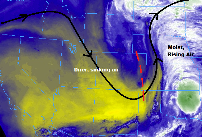
The upper-level low that brought large-scale support for showers/thunderstorms over Colorado yesterday will provide the opposite of that today. On the backside of the low, cooler air will filter into the state from the north while subsidence (sinking air) dominates the upper-levels. This sinking air, combined with lessened moisture, will lead to a drier day overall. A few isolated showers, and perhaps a weak thunderstorm or two, cannot be ruled out mainly along/east of the Continental Divide, where enough moisture will hang on to fuel garden-variety activity. Today will have an early Autumn-like feel to it.
Today’s Flood Threat Map
For more information on today’s flood threat, see the map below (hover over threat areas for more details). For Zone-Specific forecasts, jump below the map.


Zone-Specific Forecasts
Front Range, Southeast Mountains, Urban Corridor, Palmer Ridge, Northeast Plains, Southeast Plains, and Raton Ridge:
Drier and cooler, underneath mostly sunny skies. A few isolated showers will dot the regions, with the bulk of the activity north of I-70, nearest the departing upper-level low. East of the mountains, a couple garden-variety thunderstorms will mingle with isolated showers; heavy rainfall is not expected. Generally speaking, rain rates will be less than 0.15 inches/hour, with maximum rates as follows:
Front Range and Southeast Mountains: 0.2-0.35 inches/hour
Urban Corridor, Palmer Ridge, and Raton Ridge: 0.3-0.5 inches/hour
Northeast Plains and Southeast Plains. 0.4-0.6 inches/hour
Timing: 10 AM – 7 PM for the Urban Corridor, Front Range, and Northeast Plains; 2 PM – 8 PM for the Southeast Mountains, Palmer Ridge, Raton Ridge, and Southeast Plains
Northern Mountains, Northwest Slope, Central Mountains, Grand Valley, San Juan Mountains, Southwest Slope, and San Luis Valley:
High temperatures will be right around normal today underneath mostly sunny skies. A couple isolated showers, and perhaps a rumble of thunder or two, cannot be ruled out for the higher terrain of the Northern Mountains and eastern Central Mountains regions. Rain rates will remain below 0.15 inches/hour. Overall, it will be a pleasant end to the weekend for nearly all locations.
Timing: 11 AM – 5 PM