Issue Date: Tuesday, August 21st, 2018
Issue Time: 09:25AM MDT
— A MODERATE flood threat has been issued for the Lake Christine, Hayden Pass and Spring Creek burn areas
— A MODERATE flood threat has been issued for portions of the Northwest Slope, Northern Mountains, Central Mountains, Grand Valley, Palmer Ridge, Southeast Plains, Front Range and Urban Corridor
— A LOW flood threat has been issued for all zones excluding the San Luis Valley
Lots of cloud cover over the state to start this morning along with some moderate to light showers over the Central Mountains and far Northeast Plains. Haze is still being reported over the Southeast Plains with some fog near Trinidad. Between the shifting upper-level winds and rainfall today, we should get a break from what feels like the never ending haze. The early morning rainfall over the mountains also indicates that moisture has returned to the area. PW values at Grand Junction and Denver were at 0.88 and 0.85 inches, respectively. Both are expected to increase throughout the day with the monsoon moisture plume surging north. With the 500mb high shifting into Texas, dew points (Tds) this afternoon will likely reach the mid-to-upper 50Fs along the Urban Corridor with Tds just over 60F in the Southeast Plains as southeasterly surface flow resumes. The ongoing showers over western Colorado will help moisten the lower levels, so rainfall totals can be expected to increase throughout the day.
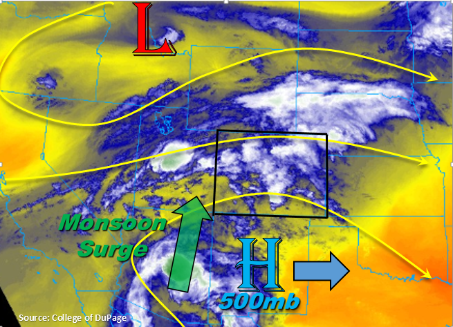
The approaching shortwaves during the course of the day will help create widespread showers both east and west of the Continental Divide by increasing lift. More than one round of storms are expected over Western CO today, and some trailing storms will be likely over eastern CO as well as clusters of thunderstorms this evening over the plains. An upper level jet will also move into western Colorado, so this should keep storm movement to the west at a fairly decent speed. However, with the monsoon surge, heavy local rainfall will still be likely. Showers are also expected overnight thanks to jet, which may bring localized 24-hour totals exceeding 2 inches over the Central Mountains and Southeast Plains. A Moderate and Low flood threat have been issued.
Some more isolated, severe storms are possible over the Southeast Plains this afternoon. Moderate shear and high instability would support damaging winds, large hail and heavy rainfall. The severe threat should end a couple hours after sundown, but the cluster of storms should is expected to produce rainfall into the early morning. Today, rainfall rates will be potentially problematic for recent burn scars. A Moderate threat has been issued for the Lake Christine, Hayden Pass and Spring Creek burn scars due to higher confidence rainfall rates in the area will exceed 0.5 inches/hour, which has caused flooding issues in the past. A Low flood threat for the other recent burn scars should suffice. Threats today over the higher terrains and burn scars include mud flows, debris slides, arroyo flooding, local stream flooding and flooding of low lying roadways. Over flatter terrains and urban areas, field ponding and street flooding are possible.
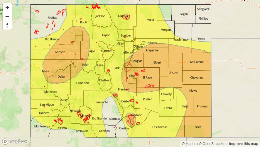
Today’s Flood Threat Map
For more information on today’s flood threat, see the map below. For Zone-Specific forecasts, scroll below the map.

Zone-Specific Forecasts:
Grand Valley, Central Mountains, San Juan Mountains, San Luis Valley, Southwest Slope, Northern Mountains, Northwest Slope:
A couple rounds of showers and thunderstorms expected over western CO today. The lower valleys are also expected to get on the rainfall, which is very much needed. A jet will move into western CO, which will help support showers and weak thunderstorms overnight into tomorrow morning over the Central Mountains. Localized totals over the Central Mountains around 2 inches by tomorrow morning are possible. Burn scars, especially Lake Christine, will be susceptible to flash flooding today and overnight. Max 1-hr rain rates up to 1.2 inches are possible though most 1-hour totals will be in the 0.5-0.8 inch range under the stronger storms. A Low and Moderate flood threat have been issued.
Primetime: 12PM – 4AM
Southeast Plains, Raton Ridge, Southeast Mountains, Front Range, Palmer Ridge, Northeast Plains, Urban Corridor:
Showers and thunderstorms should be relatively widespread this afternoon and evening with some isolated severe storms possible over the Southeast Plains. Threats include large hail, damaging winds and local heavy rainfall until about 9 PM. As storms move into the adjacent plains off the Front Range and Southeast Mountains, they will move into Tds in the upper 50Fs to low 60Fs. A cluster of thunderstorms will be likely over this area due to the high moisture and increased lift, and rainfall will likely continue into tomorrow morning. Localized 24-hr totals exceeding 2 inches are possible over the Southeast Plains. Max 1-hr rain rates up to 1 inch (west) and 1.75 inches (east) are possible today. A Moderate flood threat has been issued for the Spring Creek and Hayden Pass burn scars due to increased confidence max 1-hour rain rates in the area will exceed 0.5 inches. A Low flood threat has been issued for all other areas.
Primetime: 12PM – 3AM