Issue Date: Monday, August 20th, 2018
Issue Time: 09:05 AM MDT
— Flooding is NOT expected
Nice cool start to Monday morning with pleasant high temperatures on their way. Over the eastern plains, lows overnight were around 50F. A bit of fog and lots of haze being reported this morning over the state, but the fog should burn off quickly with the morning heating. Smoke returns statewide again today under northwesterly flow aloft. More westerly flow aloft this evening with the approaching trough over Nevada and eastward movement of the 500mb high will reduce the near surface smoke by tomorrow morning. As the trough moves westward throughout the day, the upper disturbance and jet streak will bring light showers and weak thunderstorms to the northwest corner of the state this evening. The shortwave (marked in orange below) is expected to arrive after peak heating, so the chances for strong convection will be reduced. Also, a lot of dry air has been entrained behind the last system, so not expecting high rainfall totals. However, upper support from the jet could help keep showers and thunderstorm active in the overnight hours into tomorrow morning favoring the Central and Northern Mountains. By early tomorrow morning, the disturbance will move into eastern Colorado bringing showers and cloud cover to start Tuesday morning. This will mostly affect the northern portions of the Front Range, Urban Corridor and Northeast Plains. Elsewhere, there is a slight chance for a couple showers over the Southeast Mountains this afternoon. Outside of the Southeast Mountains, rain is not expected over eastern Colorado. Without strong convection and inadequate low-level moisture, flooding is not expected today.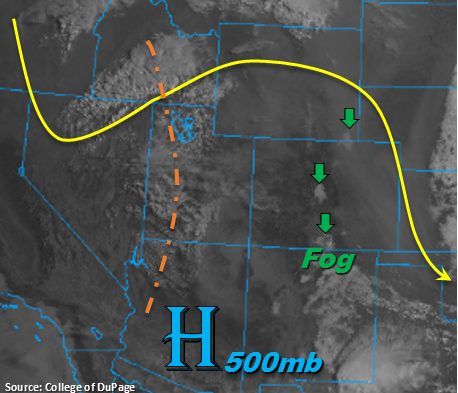
Today’s Flood Threat Map
For more information on today’s flood threat, see the map below. For Zone-Specific forecasts, scroll below the map.
Zone-Specific Forecasts:
Grand Valley, Central Mountains, San Juan Mountains, San Luis Valley, Southwest Slope, Northern Mountains, Northwest Slope:
A couple rounds of showers possible this afternoon and overnight favoring the Northern and Central Mountains. The lower valleys could also get a bit of rain, though it will most likely be a sprinkle here or there with lots of cloud cover. As the jet approaches with the next upper trough, it will help support showers and thunderstorms overnight into tomorrow morning. These will have the chance to be more wetting; however, dry air will limit totals with rainfall totals not exceeding 0.2 inches by tomorrow morning. Smoke is expected to be dense throughout the day, but there should be some relief by tomorrow morning as flow aloft turns more westerly. Flooding is not expected today.
Primetime: 4PM – 9AM
Southeast Plains, Raton Ridge, Southeast Mountains, Front Range, Palmer Ridge, Northeast Plains, Urban Corridor:
Quite a bit of surface smoke expected today with the northwesterly flow aloft. High temperatures today should be closer to 80F over the plains, which is always more enjoyable than 90F+. An isolated shower or two is possible over the Southeast Mountains this afternoon, but these should be brief and produce rain rates under 0.5 inches/hour. Tomorrow morning expecting cloud cover and some showers over the northern portion of these regions with the approaching trough. Should be another cool night with no flooding expected.
Primetime: 4PM – 8PM