FTB 08-30-2018: Critical Fire Weather Returns to the Forecast

Issue Date: Thursday, August 30th, 2018
Issue Time: 08:00AM MDT

— Flooding is NOT expected today

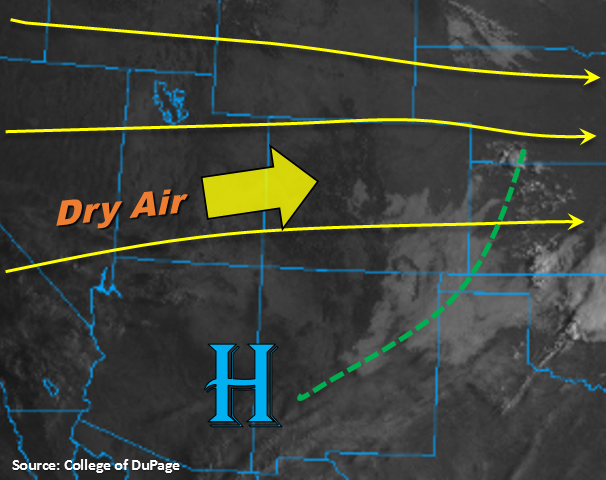
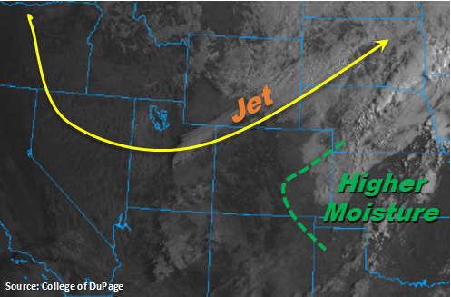
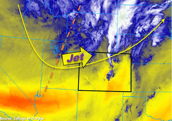
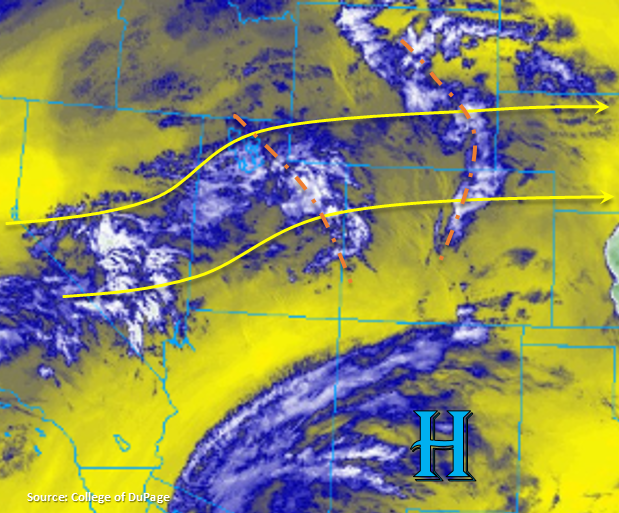
The 500mb high will continue to spin over NM today, which will keep the subtropical moisture to our south once again. Similar to the last couple of days, this will keep flow aloft west/west southwest flow and continue to entrain a drier air mass, which should keep the chance of storms low again this afternoon. A couple of shortwaves are marked in the water vapor imagery below associated with the trough that is moving over the west coast. While this may aid in a slight moisture increase, the storms that form with convergence over the Palmer/Cheyenne Ridges and extra lift from the shortwaves will likely produce some gusty winds due to the lack of low-level moisture. The shortwave over Utah is expected to help increase the upper-level clouds over the Urban Corridor, Palmer Ridge and Northeast Plains this afternoon and overnight. Over the Southeast Plains, weak convergence may spark a couple of isolated thunderstorms. With dew points below 50F, these storms will likely produce some spotty rainfall with gusty winds.

This afternoon stronger upper-level winds will set up along the CO/WY boarder, which will bring back the chances for some gusty winds to mix down to the surface. Low relative humidity and stronger winds will bring back critical fire weather to the northern half of the state. A Red Flag Warning has been issued for the Grand Valley, Northwest Slope and Northern Mountains through 9PM tonight. As anticipated, there is no flood threat forecast for Thursday.

Today’s Flood Threat Map

For more information on today’s flood threat, see the map below. For Zone-Specific forecasts, scroll below the map.

Zone-Specific Forecasts:

Southeast Plains, Raton Ridge, Southeast Mountains, Front Range, Palmer Ridge, Urban Corridor, Northeast Plains:

Lack of low-level moisture and downsloping winds will limit the chances for rainfall this afternoon. Storms that are able to fire will be high-based once again and produce some gusty winds. The shortwave currently moving through Utah will reach the Urban Corridor, Front Range, Palmer Ridge and Northeast Plains by this afternoon. While not much rainfall is expected, there should be enough of an increase in moisture that cloud cover will be on the rise. Max 1-hr rain rates are expected to be 0.05 inches or less. Some isolated storms are also possible over the southern Southeast Plains with max 1-hour rain rates up to 0.1 inches. Flooding is not expected today.

Primetime: 3PM – 8PM

Grand Valley, Central Mountains, San Juan Mountains, San Luis Valley, Southwest Slope, Northern Mountains, Northwest Slope:

A tight gradient near the CO/WY border is expected to mix down some strong winds this afternoon. Gusts between 25-35 mph are forecast. With dry air entrainment from the west and rising high temperatures, relative humidity values are expected to drop into the teens. This means critical fire weather will return to the Grand Valley, Northwest Slope and Northern Mountains through this evening. The lack of low-level moisture will again nearly zero out the chances for rainfall over western Colorado. Upper-level cloud cover is expected to increase with the passing shortwaves, so low temperatures tonight may be a couple of degrees higher than they otherwise would be. Flooding is not expected.

FTB 08-29-2018: Rebound to Near Seasonal Temperatures with Isolated Storms Possible over Eastern Colorado

Issue Date: Wednesday, August 29th, 2018
Issue Time: 08:35AM MDT

— Flooding is NOT expected today

High clouds to start the morning over the Southeast Plains with morning temperatures rebounding to more seasonal values. Expecting high temperatures to be at or a couple degrees above normal today. The high clouds are expected to continue to mix out with the daytime heating over the next couple of hours with sunny skies forecast for the rest of the day. Today, flow aloft will become a bit more southwesterly, which will pull in the cloud free, dry air from Utah and Arizona. This also means good visibility with another break from the smoke. Subtropical moisture should remain south and east of our area with the placement of the 500mb high over AZ/NM.

The continued entrainment of dry air over western Colorado will nearly zero-out the chances for rainfall again, although high cloud cover is expected to increase into this afternoon and evening. There is a slight chance for some high-based showers over the San Juan Mountains near the Continental Divide, though virga is the more likely scenario. To the west, weak upslope flow will set up again this afternoon. With limited moisture under the ridge, storms are expected to be high-based and isolated in nature. The best chances for rainfall and cloud cover today will be near areas of extra convergence, so this will be along the Raton, Palmer and Cheyenne Ridges. The weaker showers and thunderstorms that are able to form will move eastward and disperse as the sun sets. Flooding is not expected today.

Today’s Flood Threat Map

For more information on today’s flood threat, see the map below. For Zone-Specific forecasts, scroll below the map.

Zone-Specific Forecasts:

Southeast Plains, Raton Ridge, Southeast Mountains, Front Range, Palmer Ridge, Urban Corridor, Northeast Plains:

High temperatures are expected to rebound this afternoon, so the pleasant, cooler temperatures were short-lived. The best chance for afternoon storms today are along the Cheyenne, Palmer and Raton Ridge (in that order). Limited low-level moisture is expected to produce high-based storms that are isolated in nature. Max 1-hour rain rates up to 0.5 inches (north) and 0.3 inches (south) are possible. As expected, flooding is not forecast today.

Primetime: 3PM – 9PM

Grand Valley, Central Mountains, San Juan Mountains, San Luis Valley, Southwest Slope, Northern Mountains, Northwest Slope:

Southwesterly winds aloft will continue to entrain dry air today, so there is an elevated fire risk once again though wind/relative humidity values won’t reach critical fire conditions. This west/southwest flow aloft also means another break from the smoke! Temperatures are expected to be at or a couple degrees above normal. Forecasting high clouds to increase this afternoon with an outside chance of an isolated shower over the eastern San Juan Mountains.

Primetime: 3PM – 7PM


FTB 08-28-2018: Cold Front Brings a Refreshing Start to the Morning over Eastern Colorado

Issue Date: Tuesday, August 28th, 2018
Issue Time: 08:55AM MDT

— Flooding is NOT expected today

Cold front moved through the eastern plains overnight, which brought nice, crisp morning temperatures to eastern Colorado. Generally, temperatures are 10-15F cooler than this time yesterday. A southwest to northeast oriented band of clouds is seen in the visible imagery below. These clouds are associated with the right entrance of the upper-level jet streak. Today this feature will sag southward, which may provide a line of light showers over the Front Range, Urban Corridor and Northeast Plains. However, better low-level moisture will be to the east of the green line below, so not expecting totals greater than 0.4 inches. With much drier air over western Colorado, there will likely just be high clouds associated with this feature over the Northern and Central Mountains.

Upslope flow will also return to the forecast for this afternoon, which may help a little with increased storm coverage along the Front Range and Palmer Divide. However, moisture return behind the cold front was weak, so not expecting too much instability to build this afternoon. There will be a bit higher dew points further south, over the Palmer Divide, so this will translate to a tad more rainfall from the storms today. As the storms move to the east off the mountains into the adjacent plains, they are expected to weaken with the decreasing instability.

Today’s Flood Threat Map

For more information on today’s flood threat, see the map below. For Zone-Specific forecasts, scroll below the map.

Zone-Specific Forecasts:

Southeast Plains, Raton Ridge, Southeast Mountains, Front Range, Palmer Ridge, Urban Corridor:

Storms are expected to initiate along the Front Range and Palmer Ridge this afternoon. The right entrance of the jet will promote upward motion as well as the return of upslope flow. Max 1-hour rain rates up to 0.4 inches (north) and 0.7 inches (south) are possible. The high-based storms could also produce some gusty outflow winds this afternoon and evening. Less of a chance for storms over the Southeast Mountains, though an isolated storm or two can’t be ruled out. As the storms move to the east they are expected to weaken with decreasing instability. Flooding is not expected today.

Primetime: 3PM – 10PM

Grand Valley, Central Mountains, San Juan Mountains, San Luis Valley, Southwest Slope, Northern Mountains, Northwest Slope, Northeast Plains:

Westerly winds aloft will continue to entrain dry air today. So even though upslope flow will occur this afternoon, measurable rainfall will not be in the forecast. Expecting mostly clear skies with some cloud cover over the Northern and Central Mountains associated with the sagging jet. Near-surface smoke is expected to decrease into the evening. The heaviest smoke today will be over the northwest corner of the state, though it is not expected to limit visibility too much.

FTB 08-27-2018: Passing Jet Expected to Bring Gusty Winds and Critical Fire Weather Back into the Forecast

Issue Date: Monday, August 27th, 2018
Issue Time: 08:30AM MDT

— Flooding is NOT expected today

The trough will begin to pass to the north today. Out in front of it, lifting motion has caused some early morning showers and cloud cover over the northern portion of the state. Both should start to diminish throughout the morning. Today, the jet stream will dip into the northwest corner of Colorado and work eastward into the night. This will promote downsloping winds statewide and nearly eliminate the threat for afternoon showers and thunderstorms. There is still a small chance for a sprinkle or two over the eastern San Juan Mountains, but limited moisture will likely produce only high clouds and virga.

Over the northern half of the state, strong winds associated with the upper and mid-level jet are expected to mix down to the surface. This will create critical fire weather as the westerly winds will also promote low relative humidity values. Over the Northwest Slope and Northern Mountains, winds are expected in the 25-35 mph range with gusts up to 50 mph. Higher gusts will be likely over mountain passes. Over the Front Range, Urban Corridor and Northeast Plains, 20-25 mph winds will be likely this afternoon with gusts up to 40 mph. Foothills gusts could reach 60 mph. A Red Flag Warning has been issued through this evening as relative humidity values will fall into the teens. Late tonight, a cold front is forecast to pass through the state. This should knock down high temperatures on Tuesday quite a bit over eastern Colorado. Flooding is not expected today.

Today’s Flood Threat Map

For more information on today’s flood threat, see the map below. For Zone-Specific forecasts, scroll below the map.

Zone-Specific Forecasts:

Grand Valley, Central Mountains, San Juan Mountains, San Luis Valley, Southwest Slope, Northern Mountains, Northwest Slope, Northeast Plains:

Strong westerly wind are expected to mix down to the surface today producing windy conditions over the northwest corner of the state. An isolated shower may be possible over the eastern San Juans near the Continental Divide, but measurable rainfall is not likely. Please use extra caution today with anything that could cause a spark as critical fire weather is forecast. Should be another hot, August day. Flooding is not expected today.

Southeast Plains, Raton Ridge, Southeast Mountains, Front Range, Palmer Ridge, Urban Corridor:

Downsloping winds and drying will produce relative humidity values in the teens over the northern half of these zones. A Red Flag Warning has been issued through this evening. Gusty winds in the foothills will be likely this afternoon with gusts spreading into the adjacent plains. Winds will be a bit weaker further south, but gusts up to 25 mph are still possible. Downsloping winds will eliminate the chances for rainfall this afternoon. A fairly strong cold front passes through overnight, and in its wake, some fog and cloud cover is possible tomorrow morning over the eastern plains.