Issue Date: Monday, August 27th, 2018
Issue Time: 08:30AM MDT
— Flooding is NOT expected today
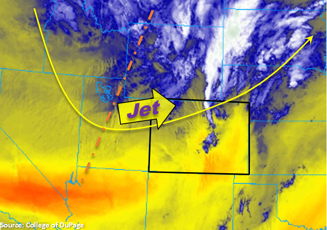
The trough will begin to pass to the north today. Out in front of it, lifting motion has caused some early morning showers and cloud cover over the northern portion of the state. Both should start to diminish throughout the morning. Today, the jet stream will dip into the northwest corner of Colorado and work eastward into the night. This will promote downsloping winds statewide and nearly eliminate the threat for afternoon showers and thunderstorms. There is still a small chance for a sprinkle or two over the eastern San Juan Mountains, but limited moisture will likely produce only high clouds and virga.
Over the northern half of the state, strong winds associated with the upper and mid-level jet are expected to mix down to the surface. This will create critical fire weather as the westerly winds will also promote low relative humidity values. Over the Northwest Slope and Northern Mountains, winds are expected in the 25-35 mph range with gusts up to 50 mph. Higher gusts will be likely over mountain passes. Over the Front Range, Urban Corridor and Northeast Plains, 20-25 mph winds will be likely this afternoon with gusts up to 40 mph. Foothills gusts could reach 60 mph. A Red Flag Warning has been issued through this evening as relative humidity values will fall into the teens. Late tonight, a cold front is forecast to pass through the state. This should knock down high temperatures on Tuesday quite a bit over eastern Colorado. Flooding is not expected today.
Today’s Flood Threat Map
For more information on today’s flood threat, see the map below. For Zone-Specific forecasts, scroll below the map.
Zone-Specific Forecasts:
Grand Valley, Central Mountains, San Juan Mountains, San Luis Valley, Southwest Slope, Northern Mountains, Northwest Slope, Northeast Plains:
Strong westerly wind are expected to mix down to the surface today producing windy conditions over the northwest corner of the state. An isolated shower may be possible over the eastern San Juans near the Continental Divide, but measurable rainfall is not likely. Please use extra caution today with anything that could cause a spark as critical fire weather is forecast. Should be another hot, August day. Flooding is not expected today.
Southeast Plains, Raton Ridge, Southeast Mountains, Front Range, Palmer Ridge, Urban Corridor:
Downsloping winds and drying will produce relative humidity values in the teens over the northern half of these zones. A Red Flag Warning has been issued through this evening. Gusty winds in the foothills will be likely this afternoon with gusts spreading into the adjacent plains. Winds will be a bit weaker further south, but gusts up to 25 mph are still possible. Downsloping winds will eliminate the chances for rainfall this afternoon. A fairly strong cold front passes through overnight, and in its wake, some fog and cloud cover is possible tomorrow morning over the eastern plains.