Issue Date: Tuesday, August 28th, 2018
Issue Time: 08:55AM MDT
— Flooding is NOT expected today
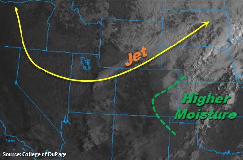
Cold front moved through the eastern plains overnight, which brought nice, crisp morning temperatures to eastern Colorado. Generally, temperatures are 10-15F cooler than this time yesterday. A southwest to northeast oriented band of clouds is seen in the visible imagery below. These clouds are associated with the right entrance of the upper-level jet streak. Today this feature will sag southward, which may provide a line of light showers over the Front Range, Urban Corridor and Northeast Plains. However, better low-level moisture will be to the east of the green line below, so not expecting totals greater than 0.4 inches. With much drier air over western Colorado, there will likely just be high clouds associated with this feature over the Northern and Central Mountains.
Upslope flow will also return to the forecast for this afternoon, which may help a little with increased storm coverage along the Front Range and Palmer Divide. However, moisture return behind the cold front was weak, so not expecting too much instability to build this afternoon. There will be a bit higher dew points further south, over the Palmer Divide, so this will translate to a tad more rainfall from the storms today. As the storms move to the east off the mountains into the adjacent plains, they are expected to weaken with the decreasing instability.
Today’s Flood Threat Map
For more information on today’s flood threat, see the map below. For Zone-Specific forecasts, scroll below the map.
Zone-Specific Forecasts:
Southeast Plains, Raton Ridge, Southeast Mountains, Front Range, Palmer Ridge, Urban Corridor:
Storms are expected to initiate along the Front Range and Palmer Ridge this afternoon. The right entrance of the jet will promote upward motion as well as the return of upslope flow. Max 1-hour rain rates up to 0.4 inches (north) and 0.7 inches (south) are possible. The high-based storms could also produce some gusty outflow winds this afternoon and evening. Less of a chance for storms over the Southeast Mountains, though an isolated storm or two can’t be ruled out. As the storms move to the east they are expected to weaken with decreasing instability. Flooding is not expected today.
Primetime: 3PM – 10PM
Grand Valley, Central Mountains, San Juan Mountains, San Luis Valley, Southwest Slope, Northern Mountains, Northwest Slope, Northeast Plains:
Westerly winds aloft will continue to entrain dry air today. So even though upslope flow will occur this afternoon, measurable rainfall will not be in the forecast. Expecting mostly clear skies with some cloud cover over the Northern and Central Mountains associated with the sagging jet. Near-surface smoke is expected to decrease into the evening. The heaviest smoke today will be over the northwest corner of the state, though it is not expected to limit visibility too much.