Issue Date: Monday, September 3rd, 2018
Issue Time: 09:10AM MDT
— A LOW flood threat has been issued for portions of the Southeast Plains, Northeast Plains, Palmer Ridge and Raton Ridge
— A LOW flood threat has been issued for the 416/Burro and Spring Creek burn areas
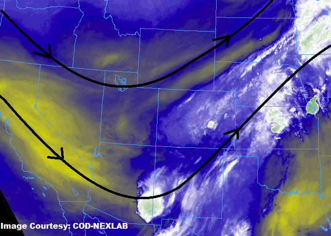
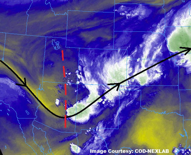
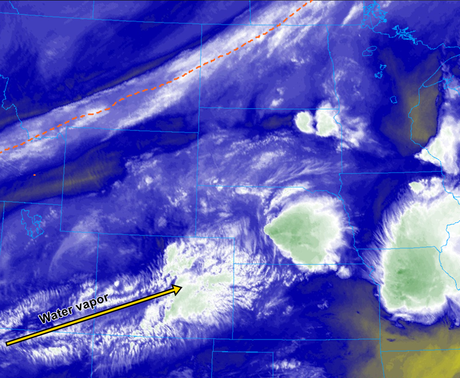
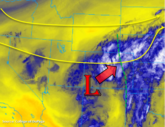
Cool morning with quite a bit of cloud cover over the state to start Labor Day. There is also some moderate rainfall (and snow at higher elevations) being reported over the San Juan Mountains with dense fog over the far eastern plains that is limiting visibility to the 0.25-0.75 mile range. This is all associated with the upper low over the Southwest Slope, which is marked in the water vapor imagery below. That circulation will slowly start moving to the northeast throughout the day and into tonight, which will help keep rainfall chances fairly widespread.
Showers are expected to increase throughout the day over the western high terrains. Better moisture will be available over the San Juan Mountains, so expecting the highest 24-hour totals over this region. Ongoing cloud cover will limit the amount of instability that can build, but with slow steering winds aloft, max 1-hour rain rates up to 0.6 inches/hour are possible over the 416/Burro burn areas. Therefore, a Low flood threat has been issued for these recent burn areas. Threats including mud flows, debris slides and flash flooding of local streams.
To the east, southeasterly surface winds will help keep low-level moisture in place over the eastern plains. Precipitable Water values will also be on the rise and are forecast to exceed 1 inch this afternoon. This higher low-level moisture should remain over the adjacent plains, so flood threat criteria will not be met over Front Range and Southeast Mountains. The one exception will be the Spring Creek burn scar, where 1-hour totals will likely exceed 0.25 inches, so a Low flood threat has been issued. The big question this afternoon is how much and how quickly the cloud cover will burn off. The earlier the cloud cover burns off, the more instability will be able to build for afternoon thunderstorms. At this time, leaning towards a moderate amount of instability over the far eastern plains as we’re already starting to see clouds break up a bit. The moderate instability paired with slow steering winds aloft to the NNE, should increase rainfall totals over the eastern plains when compared to yesterday. There is a fairly good chance that minimal flood threat criteria will be reached over this area, so a Low flood threat has been issued. With drier soils and healthy crops, the nature of the flooding should be localized.
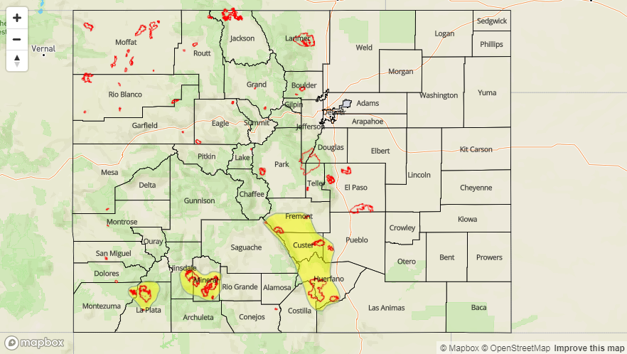
Today’s Flood Threat Map
For more information on today’s flood threat, see the map below. For Zone-Specific forecasts, scroll below the map.
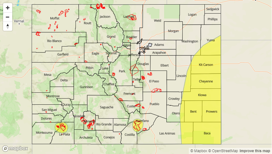

Zone-Specific Forecasts:
Southeast Plains, Raton Ridge, Southeast Mountains, Front Range, Palmer Ridge, Urban Corridor, Northeast Plains:
Showers and thunderstorms are likely this afternoon with the heavier totals expected over the eastern plains. Over the higher terrains, storms are expected to be more widespread over the Palmer Ridge/Southern Front Range intersect and the Southeast Mountains with isolated coverage further north. Max 1-hour rain rates up to 0.75 inches (west) and 1.8 inches (east) are possible. A Low flood threat has been issued for the Spring Creek burn area as well as for the far eastern plains. Threats over the burn scar include localized stream flooding, mud flows and debris slides. Over the eastern plains, localized stream and arroyo flooding is possible along with field ponding and flooding of low-lying roads. Storms should end around midnight over the higher terrains with storms ending a couple hours later over the eastern plains.
Primetime: 12PM – 3AM
Grand Valley, Central Mountains, San Juan Mountains, San Luis Valley, Southwest Slope, Northern Mountains, Northwest Slope:
Showers should continue to pick up in intensity over the higher terrains throughout the day. Better moisture remains to the south, so the highest totals are expected over the San Juan Mountains though 24-hour totals close to 1 inch are possible over the Central Mountains. Instability will be minimal, so storms should be more stratiform rather than convective in nature though some isolated thunder is likely. Max 1-hour rain rates up to 0.7 inches (south) and 0.3 inches (north) are possible. A Low flood threat has been issued for the 416/Burro burn areas with localized flooding, mud flows and debris slides being a threat for storms that track directly over the recent scars. Storms are expected to end a few hour after sundown though a couple showers could linger near the Continental Divide overnight.
Primetime: 11AM – 10PM