Issue Date: 9/1/2018
Issue Time: 8:00 AM
NO FLOOD THREAT IS FORECAST TODAY.
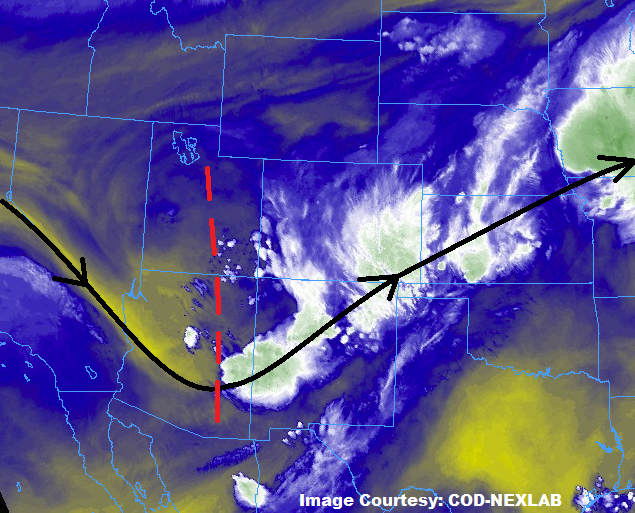
An upper-level trough currently situated with its axis (red dashed line) over Utah and Arizona will advance into western Colorado today, continuing the influx of mid-level moisture from the south-southwest into the state. A few weak disturbances ahead of the axis will shift across Colorado today and tonight, providing a few triggers for scattered showers and thunderstorms. Low-level moisture across much of the state remains lackluster, generally speaking, so most of the activity today will remain high-based, producing gusty winds, lightning, and brief periods of light-to-moderate rainfall.
While no flood threat has been issued, sensitive burn scars of the Southwest Slope, San Juan Mountains, and Southeast Mountains may need some attention today should multiple rounds of marginal rainfall move overhead. However, due to the scattered nature of showers/thunderstorms today, their generally high-based nature, and expected quick storm motions to the east-northeast, no flood threat is warranted.
Today’s Flood Threat Map
For more information on today’s flood threat, see the map below (hover over threat areas for more details). For Zone-Specific forecasts, jump below the map.


Zone-Specific Forecasts
Urban Corridor, Palmer Ridge, Northeast Plains, Southeast Plains, and Raton Ridge:
Scattered showers and thunderstorms are expected today and tonight across the area. Most activity will be garden variety, producing more wind than rain, as low-level moisture isn’t favorable for heavy rainfall. The bets moisture, and therefore the best chance at strong thunderstorms capable of periods of moderate-to-heavy rainfall will be east of a line drawn through Raymer-Fort Morgan-Limon-Ordway-Branson. Maximum rain rates are as follows:
Urban Corridor: 0.3-0.6 inches/hour
Palmer Ridge: 0.4-0.8 inches/hour
Northeast Plains and Southeast Plains: 1.0-1.5 inches/hour
Raton Ridge: 0.4-0.6 inches/hour
Timing: 1 PM – 10 PM for the Urban Corridor, 1 PM – Midnight for the Northeast Plains and Palmer Ridge, Ongoing – 2 AM for the Raton Ridge and Southeast Plains
Northern Mountains, Northwest Slope, Front Range, Central Mountains, Grand Valley, Southeast Mountains, San Juan Mountains, Southwest Slope, and San Luis Valley:
Scattered, high-based showers and thunderstorms are expected today/tonight as the upper-level trough moves into the area. Moisture is lacking, generally speaking, and storm motions are relatively quick, so no flood threat is warranted today. As mentioned above, sensitive burn scars may need a bit of monitoring should they be impacted by multiple rounds of marginal rainfall, but the probability of flash flooding is less than 10%. Rain rates will generally be below 0.1-0.2 inches/hour, with maximum rates of 0.2-0.4 inches/hour for thunderstorms south of I-70.
Timing: 11 AM – 11 PM for the Southwest Slope, San Juan Mountains, Southeast Mountains, and San Luis Valley, 11 AM – 9 PM for the Northwest Slope, Northern Mountains, Central Mountains, Front Range, and Grand Valley