Issue Date: 9/2/2018
Issue Time: 8:00 AM
A LOW FLOOD THREAT IS FORECAST TODAY FOR PORTIONS OF THE SOUTHWEST SLOPE, SAN JUAN MOUNTAINS, SOUTHEAST MOUNTAINS, RATON RIDGE, AND SOUTHEAST PLAINS.
The upper-level trough that impacted Colorado yesterday hasn’t moved much over the previous 12-18 hours, continuing to drift slowly eastward over the 4-Corners region. This will set the stage for another afternoon/evening of isolated-to-scattered showers and thunderstorms across the state. A difference between yesterday and today will be the influx of some low-level moisture across eastern Colorado, where easterly flow will bring plains moisture towards the Front Range and Southeast Mountains. Wind shear, moisture, and pockets of instability will be sufficient to produce a couple stronger storms capable of moderate-to-heavy rainfall, thus the issuance of the low flood threat for the sensitive burn scars of southeast Colorado.
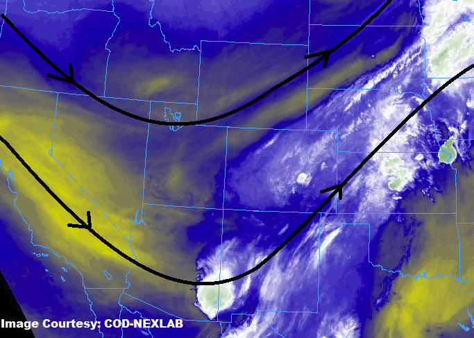
Over the High Country, areas north of I-70 will remain mostly dry tomorrow, with only a couple isolated showers dotting the higher terrain. South of I-25, the influence of a mid-level stream of moisture from the south will provide the fuel for scattered showers and thunderstorms. Most of the activity will be garden-variety, with impacts being light-to-moderate rainfall, gusty winds, and lightning. Storms will move slower than yesterday, leaving the possibility for longer residence time of moderate rainfall over a sensitive burn scar; thus, the issuance of the low flood threat for portions of the Southwest Slope and San Juan Mountains regions. For more details on rain rates and timing, please see the zone-specific forecast discussions below.
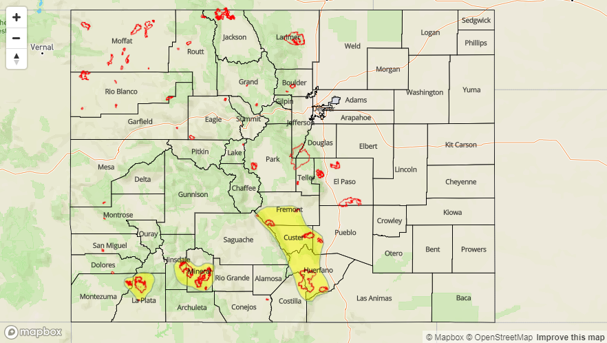
Today’s Flood Threat Map
For more information on today’s flood threat, see the map below (hover over threat areas for more details). For Zone-Specific forecasts, jump below the map.

Zone-Specific Forecasts
Front Range, Urban Corridor, Palmer Ridge, Northeast Plains, Southeast Plains, Southeast Mountains, and Raton Ridge:
Scattered showers and thunderstorms are expected, with the bulk of the activity occurring south of I-70. Storms will move slower than yesterday thanks to weaker mid-level flow, and this in partnership with an increase in moisture has led to the issuance of the low flood threat. Maximum rain rates are as follows:
Front Range: 0.2-0.4 inches/hour
Urban Corridor, Palmer Ridge, and Northeast Plains: 0.4-0.7 inches/hour
Southeast Plains and Raton Ridge: 1.0-1.3 inches/hour
Southeast Mountains: 0.5-0.7 inches/hour
Timing: A few showers are ongoing this morning across the Southeast Plains. Aside from those, timing will be 11 AM – 11 PM, with a couple lingering showers/weak thunderstorms into the early morning hours.
Northern Mountains, Northwest Slope, Central Mountains, Grand Valley, San Juan Mountains, Southwest Slope, and San Luis Valley:
Isolated showers are expected north of I-70, with scattered showers and a few thunderstorms south of I-70. The best coverage will be across the higher terrain of the San Juan Mountains, Southwest Slope, and southern Central Mountains where moisture will be best. Slow-moving storms capable of moderate rainfall are behind the issuance of the low flood threat. Maximum rain rates are as follows:
Northwest Slope and Northern Mountains: 0.1-0.2 inches/hour
Grand Valley: 0.2-0.3 inches/hour
Central Mountains, Southwest Slope, San Juan Mountains, and San Luis Valley: 0.3-0.5 inches/hour.
Timing: 11 AM – 8 PM for the Northwest Slope and Northern Mountains, 11 AM – 9 PM for the Grand Valley, and 11 AM – 1 AM for the San Juan Mountains, Southwest Slope, and San Luis Valley