FTB 09-11-2018: Critical Fire Weather for Northwest Colorado

Issue Date: Tuesday, September 11th, 2018
Issue Time: 09:15AM MDT

 — Flooding is NOT expected today

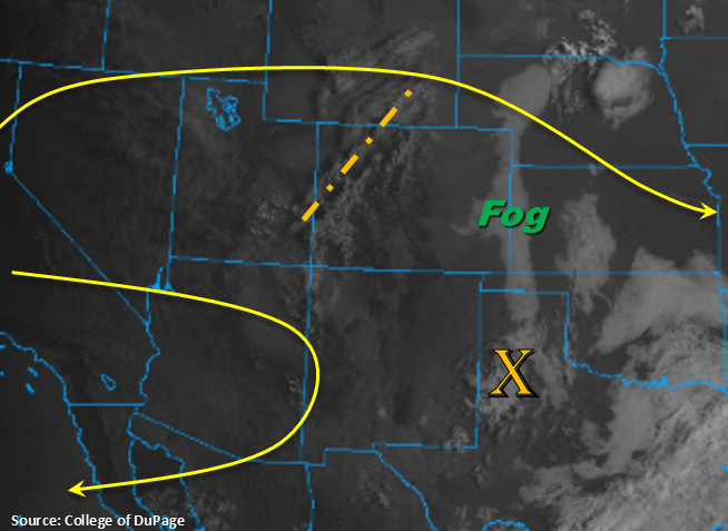
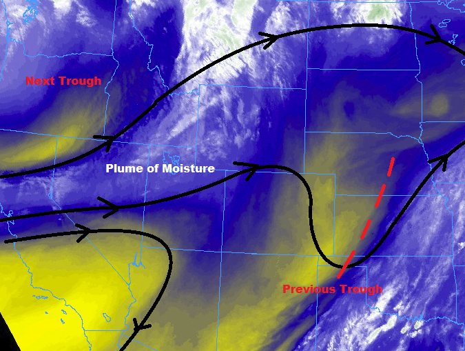
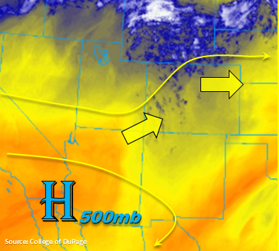
The drying and warming trend will continue today. Expecting high temperatures in the lower elevations to reach the 90F mark, which is very impressive for mid-September. Southwesterly and westerly flow aloft will continue to pull in the arid air mass seen in the water vapor imagery below (yellow and orange). Precipitable Water values were measured a little above 0.5 inches at Denver and Grand Junction with both soundings showing an inverted-V profile. Together these indicate most of the low and mid-level moisture has been mixed out, which should limit measurable rainfall chances this afternoon. The water vapor imagery below also shows a shortwave, so increased cloud cover will be likely as the feature moves eastward. While measureable rainfall chances are lower today, there is still a chance for an isolated light shower or two along the Continental Divide this afternoon. Expect some gusty outflow winds rather than wetting rains with storms that are able to form. If the shortwave is able to help maintain a weak storm into the adjacent plains, strong outflow winds are likely as the storm evaporates (similar to yesterday). Lastly, warm temperatures and low relative humidity will be paired with some stronger surface winds over northwest Colorado today, which is expected to produce critical fire weather. A Red Flag Warning is in place from 11AM this morning to 8PM this evening with surface winds forecast to be between 15 and 25 mph.

Today’s Flood Threat Map

For more information on today’s flood threat, see the map below. For Zone-Specific forecasts, scroll below the map.

Zone-Specific Forecasts:

Southeast Plains, Palmer Ridge, Urban Corridor, Northeast Plains, Raton Ridge, Southeast Mountains, Front Range, San Juan Mountains, San Luis Valley, Southwest Slope:

The drying and warming trend continues, which should produce 90F temperatures in the lower elevations with highs in the 70Fs over the higher elevations. A few light showers are possible along and near the Continental Divide this afternoon, but gusty winds and increased cloud cover are more likely than measureable rainfall. Max 1-hr totals up to 0.1 inches are possible though most storms will likely produce sprinkles. There is a chance that a storm or two survives into the adjacent plains with help from the shortwave. Although rainfall totals would increase slightly, these storms could produce strong outflow winds as they evaporate.

Primetime: 1PM to 8PM

Grand Valley, Central Mountains, Northern Mountains, Northwest Slope:

Warmer temperature this afternoon with some strong winds mixing down to the surface. Paired with high temperatures and low relative humidity, critical fire weather is anticipated for the rest of this week. Surface winds today will likely be between 20 and 25 mph with gust around 30mph, so please use extra caution with any activity that can produce a spark. A Red Flag Warning is in effect from 11AM to 8PM.


FTB 09-10-2018: Plentiful Sunshine and Warm Temperatures with Isolated Storms over the Southern High Terrains

Issue Date: Monday, September 10th, 2018
Issue Time: 08:45M MDT

— Flooding is NOT expected today

Similar atmospheric setup to Sunday. Colorado will be under the influence of a weak ridging pattern today with and another shortwave rotating around the ridge axis marked in the visible imagery below. Winds aloft over northern Colorado this afternoon will be more westerly at 20 knots with the southern half of the state having more of a northerly component to the flow. Currently, there is some fog over the eastern plains in the wake of the vorticity max that has moved south into the TX panhandle. This should burn off relatively quickly with the morning heating.

Drying of the low-levels will continue this afternoon, so storm coverage will very isolated over the higher terrains when compared to this weekend. With the high-based storms, much of the rainfall will evaporate before reaching the surface. The best chance for rain making it to the surface will be over the southern high terrains, south of I-70. Storms over the adjacent plains are unlikely this afternoon though there will likely be increased cloud cover. There is an outside chance of a storm over the Palmer Ridge (extra convergence) though virga is the more likely scenario. Cloud cover is also expected over the northern mountains tonight, which should help keep low temperatures a few degrees warmer. Flooding is not expected today.

Today’s Flood Threat Map

For more information on today’s flood threat, see the map below. For Zone-Specific forecasts, scroll below the map.

Zone-Specific Forecasts:

Southeast Mountains, Front Range, Central Mountains, San Juan Mountains:

Better moisture over the southern high terrains this afternoon though it still has decreased from this weekend. The residual moisture should spark a few storms over these regions, though storms this afternoon will be more isolated in nature. Max 1-hr rain rates up to 0.15 inches are possible. With the temperature/dew point spread being so large, storms this afternoon will be capable of producing brief, gusty winds. Flooding is not expected today.

Primetime: 2PM – 9PM

Southeast Plains, Palmer Ridge, Urban Corridor, Northeast Plains, Raton Ridge:

Fog this morning along the eastern CO border in the wake of a passing vorticity max. This should burn off relatively quickly with the daytime heating. Drying of the low-levels continues this afternoon, which should keep rainfall confined to the higher terrains. Some mid-level cloud cover is likely over the adjacent plains this afternoon with some brief winds possible as storms evaporate. There is a chance for an isolated storm over the Palmer Ridge, though the more likely scenario is virga and gusty winds.

Grand Valley, San Luis Valley, Southwest Slope, Northern Mountains, Northwest Slope:

Dry air has been entrained from the west, so not expecting any storm activity today. High temperature will also continue to increase a degree or two this afternoon. Max temps for the lower elevations will likely reach the mid-90Fs with 70Fs over the mountains. Surface winds will increase tonight into tomorrow afternoon, so there is possibility of critical fire weather arriving as soon as Tuesday afternoon. Please tune back into the FTB tomorrow for the latest.


FTB 09-09-2018: More Sunshine and Fewer Showers/Thunderstorms

Issue Date: 9/9/2018
Issue Time: 6:45 AM

NO FLOOD THREAT IS FORECAST TODAY.

Plenty of sunshine is on tap today, with high temperatures ticking up a few degrees higher than yesterday. Drier air will be filtering in from the west, but enough mid-level moisture will hang on for a few isolated high-based showers and thunderstorms during the afternoon and evening hours. A quick look at the infrared imagery below shows the current cloud cover over, much of it over the high country and south of I-70, denoting where the best mid-level moisture currently resides.

The majority of activity will occur over the High Country south of I-70 in response to remaining moisture and the presence of a weak disturbance, and a few isolated, high-based showers/thunderstorms will drift over the adjacent lower elevations of eastern Colorado. The main impacts of any activity will be gusty winds and light rainfall, with brief periods of moderate rainfall underneath any thunderstorm activity over the Southeast Plains and Raton Ridge. For more information on rain rates and timing, please see the zone-specific forecast discussions below.

Today’s Flood Threat Map

For more information on today’s flood threat, see the map below (hover over threat areas for more details). For Zone-Specific forecasts, jump below the map.

Flood Threat Legend

Zone-Specific Forecasts

Urban Corridor, Palmer Ridge, Northeast Plains, Southeast Plains, and Raton Ridge:

The main weather story today will be the plentiful sunshine and warmer temperatures, with only a couple isolated, high-based showers/thunderstorms breaking up the otherwise quiet day during the afternoon and evening hours. Most of the activity will occur west of I-25, employing the help of nearby terrain. Rain rates will be tempered by dry air beneath the cloud bases; generally speaking, rain rates will be less than 0.15 inches/hour, with maximum rain rates of 0.2-0.5 inches/hour underneath thunderstorms over the Southeast Plains and Raton Ridge.

Timing: 1 PM – 9 PM, with an isolated shower or two lingering until 10-11 PM

Front Range, Northern Mountains, Northwest Slope, Central Mountains, Southeast Mountains, Grand Valley, San Juan Mountains, Southwest Slope, and San Luis Valley:

Dry conditions and mostly sunny skies will be the main weather story for most today, with a few isolated-to-scattered showers/thunderstorms dotting the area during the afternoon/evening. The bulk of the activity will occur south of I-70 where the better moisture (relatively speaking) will be positioned. Rain rates will generally be less than 0.15 inches/hour, with maximum rain rates of 0.2-0.3 inches/hour.

Timing: Noon – 9 PM

FTB 09-08-2018: Main Course of Sunshine, Side Dish of Showers

Issue Date: 9/8/2018
Issue Time: 6:35 AM

NO FLOOD THREAT IS FORECAST TODAY.

The upper-level trough that had been meandering across the region the past couple of days has finally moved on, shifting over the central Great Plains. Behind the recent upper-level trough, and ahead of the next trough, a plume of moisture has begun to push into western Colorado, which will spread east through the day. This next wave of moisture will provide enough fuel for a few isolated-to-widely scattered showers/thunderstorms over the High Country, and a couple isolated showers/storms over adjacent lower elevations.

The best coverage, relatively speaking, will be north of I-70, where the influence of a passing disturbance will provide some support. Overall, there is no threat of flash flooding as the best moisture is confined to the mid-levels (with drier air near the surface) and there will be very little instability with which to work. Thus, gusty winds and light rain will be the main impacts. For more information on rain rates and timing, please see the zone-specific forecast discussions below.

Today’s Flood Threat Map

For more information on today’s flood threat, see the map below (hover over threat areas for more details). For Zone-Specific forecasts, jump below the map.

Flood Threat Legend

Zone-Specific Forecasts

Urban Corridor, Palmer Ridge, Northeast Plains, Southeast Plains, and Raton Ridge:

Plenty of sunshine and warmer temperatures are the main weather story for today, providing a nice kickoff to the weekend. During the afternoon/evening hours, a few clouds will bubble, especially over areas near the mountains. A couple of showers, and perhaps a thunderstorm or two will dot the area, mainly north of I-70 thanks to the presence of the passing disturbance. Gusty winds and light rainfall will be the main impacts from any activity, so no flood threat is the call today. Rainfall rates will generally be less than 0.15 inches/hour, with maximum rates of 0.2-0.4 inches/hour.

Timing: 3 PM – 11 PM, with an isolated shower/thunderstorm or two lingering into the early morning hours over the Northeast Plains in association with the passing disturbance.

Front Range, Northern Mountains, Northwest Slope, Central Mountains, Southeast Mountains, Grand Valley, San Juan Mountains, Southwest Slope, and San Luis Valley:

The day will begin with plenty of sunshine, with clouds increasing over the higher terrain during the afternoon and evening hours in response to the increase in mid-level moisture. A few isolated-to-scattered showers will dot the region, with the best coverage, relatively speaking, over the higher terrain of the Northwest Slope, Northern Mountains, Front Range, and Central Mountains. Rain rates will generally be less than 0.1 inches/hour, with maximum rates of 0.2-0.3 inches/hour.

Timing: 2 PM – 10 PM for areas south of I-70, 1 PM – 1 AM for areas along and north of I-70. A few lingering showers will continue into the early morning hours over the higher terrain of the Northern Mountains, Northwest Slope, Grand Valley, and Central Mountains.