Issue Date: Monday, September 10th, 2018
Issue Time: 08:45M MDT
— Flooding is NOT expected today
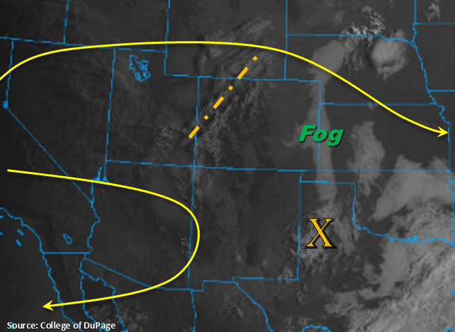
Similar atmospheric setup to Sunday. Colorado will be under the influence of a weak ridging pattern today with and another shortwave rotating around the ridge axis marked in the visible imagery below. Winds aloft over northern Colorado this afternoon will be more westerly at 20 knots with the southern half of the state having more of a northerly component to the flow. Currently, there is some fog over the eastern plains in the wake of the vorticity max that has moved south into the TX panhandle. This should burn off relatively quickly with the morning heating.
Drying of the low-levels will continue this afternoon, so storm coverage will very isolated over the higher terrains when compared to this weekend. With the high-based storms, much of the rainfall will evaporate before reaching the surface. The best chance for rain making it to the surface will be over the southern high terrains, south of I-70. Storms over the adjacent plains are unlikely this afternoon though there will likely be increased cloud cover. There is an outside chance of a storm over the Palmer Ridge (extra convergence) though virga is the more likely scenario. Cloud cover is also expected over the northern mountains tonight, which should help keep low temperatures a few degrees warmer. Flooding is not expected today.
Today’s Flood Threat Map
For more information on today’s flood threat, see the map below. For Zone-Specific forecasts, scroll below the map.
Zone-Specific Forecasts:
Southeast Mountains, Front Range, Central Mountains, San Juan Mountains:
Better moisture over the southern high terrains this afternoon though it still has decreased from this weekend. The residual moisture should spark a few storms over these regions, though storms this afternoon will be more isolated in nature. Max 1-hr rain rates up to 0.15 inches are possible. With the temperature/dew point spread being so large, storms this afternoon will be capable of producing brief, gusty winds. Flooding is not expected today.
Primetime: 2PM – 9PM
Southeast Plains, Palmer Ridge, Urban Corridor, Northeast Plains, Raton Ridge:
Fog this morning along the eastern CO border in the wake of a passing vorticity max. This should burn off relatively quickly with the daytime heating. Drying of the low-levels continues this afternoon, which should keep rainfall confined to the higher terrains. Some mid-level cloud cover is likely over the adjacent plains this afternoon with some brief winds possible as storms evaporate. There is a chance for an isolated storm over the Palmer Ridge, though the more likely scenario is virga and gusty winds.
Grand Valley, San Luis Valley, Southwest Slope, Northern Mountains, Northwest Slope:
Dry air has been entrained from the west, so not expecting any storm activity today. High temperature will also continue to increase a degree or two this afternoon. Max temps for the lower elevations will likely reach the mid-90Fs with 70Fs over the mountains. Surface winds will increase tonight into tomorrow afternoon, so there is possibility of critical fire weather arriving as soon as Tuesday afternoon. Please tune back into the FTB tomorrow for the latest.